Primary Sources
Information about the Civil War in the South-West can be found in a vast range of contemporary sources, many of which are quoted in this book. Among the most important printed sources are:
Atkyns, Richard, The Vindication of Richard Atkyns, in Military Memoirs: The Civil War (ed. Peter Young), London, 1967.
Clarendon, Edward Earl of, History of the Great Rebellion (ed. W. D. Macray), Oxford, 1888.
Hopton, Lord Ralph, Bellum Civile, in Transactions of the Somerset Record Society (ed. C. E. H. Chadwick-Healey), Vol. 18, 1902.
Sprigge, Joshua, Anglia Rediviva , London, 1647. The official history of the campaigns of the New Model Army in 164546).
Symonds, Richard, Diary of the Marches of the Royal Army (ed. C. E. Long), Camden Society, 1859.
Walker, Sir Edward, Historical Discourses upon Several Occasions , London, 1705.
The British Library, London, and the Bodleian Library, Oxford, contain major collections of relevant material, as do the County Records Offices of Cornwall, Devon, Somerset and Wiltshire as well as major libraries such as those at Exeter, Bristol and Truro.
Modern Accounts
Of major importance is the series of pamphlets dealing with almost every engagement of significance in the war published by Stuart Peachey of Historical Management Associates Ltd.
Other key accounts include:
Andriette, Eugene A., Devon and Exeter in the Civil War , Newton Abbott, 1971.
Coate, Mary, Cornwall in the Great Civil War and Interregnum , Oxford, 1933.
Stoyle, Mark, West Britons: Cornish Identities and the Early Modern British State , Exeter, 2002.
Underdown, David, Somerset in the Civil War and Interregnum , Newton Abbott, 1973.
Good general accounts of the war as a whole may be found in:
Reid, Stuart, All the Kings Armies: A Military History of the English Civil War, 16411651 , Staplehurst, 1998
Young, Peter, and Holmes, Richard, The English Civil War: a Military History of the Three Civil Wars, 164251 , London, 1974.
A more recent excellent source of information is the English Heritage website (http://english-heritage.org.uk/filestore/battlefields), whose Battlefields Register contains valuable analyses of many of the engagements discussed here.
BATTLEFIELD TOURS
Introduction
Several points may perhaps be usefully made before commencing our individual Battlefield Tours. At the time of writing (2004), of the battles discussed here, only Stratton, Lansdown and Roundway Down are reasonably well signposted and interpreted on site. Visits even to these, and still more to the others described, require both careful navigation and driving along typically high-banked and thick-hedged West Country roads, sometimes erratically signposted. As the author can testify from personal experience, becoming temporarily lost in the process is virtually inevitable from time to time. In order to minimise (but almost certainly not entirely remove) this irritant, would-be visitors are advised before setting out to study the appropriate sheet from the OS 1:25000 scale Explorer series of maps (details are given with each tour), together with the suggestions given here, and plan their route in advance. In the tours described, all the grid references quoted relate to the OS Explorer series.
Only Roundway Down of our examples has really adequate parking facilities. In the case of our other battles, limited informal parking can be found, but an exploration of virtually all of the battlefields requires some walking along lanes or more major roads which often carry a surprising volume of sometimes high-speed traffic. Great care should be exercised at all times.
A final caveat. At least part of all of our battlefields lie on private land. Bearing in mind the restrictions sometimes imposed by livestock and crops, landowners and farmers are generally co-operative in allowing responsible access to battlefield explorers. In return we should remember that our battlefields are often their workplaces, and observe the Country Code, particularly with regard to closing gates and keeping any accompanying dogs under close control.
TOUR ONE
Braddock Down
[O.S. Explorer Sheet 107]
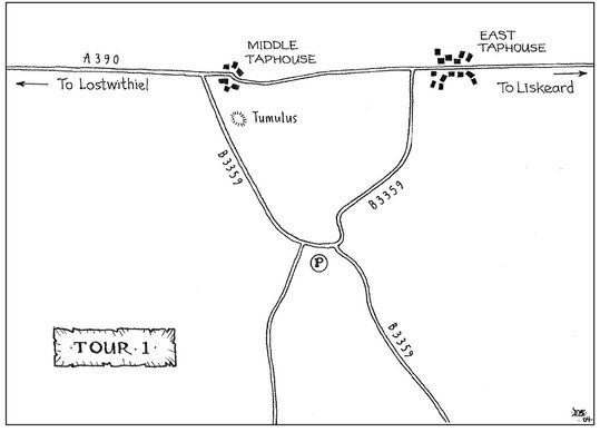
Braddock Down shares with Langport, and to a lesser extent Roundway Down, some debate over the exact location of the battle. Traditionally it was held to have been fought just to the south-west of Braddock Church. However, recent research by Rod Wilton, now accepted by the English Heritage Battlefields Register, suggests that the encounter actually took place further to the east, between the villages of Middle and East Taphouse, and this location is followed here.
A visit to Braddock Down can be conveniently included within a tour of the sites associated with the site of the Lostwithiel campaign of 1644. From Lostwithiel go east for about six miles along the A390 in the direction of Liskeard. At Middle Taphouse [SX174638] turn right along the B3359. Immediately beyond the hedges on your left is the initial position occupied by the Royalist forces. The tumulus near the junction with the A390 may be the hill on which the Royalist guns were positioned.
Continue southwards along the B3359 for just over half a mile. On the right, immediately after passing a turning on the left into a minor road, there is a small informal parking place. From here, looking north, the best view of the field may be obtained. On the left is the rising ground occupied by Hopton. To the right is the ridge where Ruthvens Parliamentarians were positioned. The dip across which the Royalists attacked (now partly wooded) is clearly visible.
At the junction turn left, and return north, again along the B3359 (the roads on both sides of the battlefield somewhat confusingly have the same numbering). Largely obscured by hedges, Ruthvens position lies to your left. On reaching the A390, turn left to return to Lostwithiel.
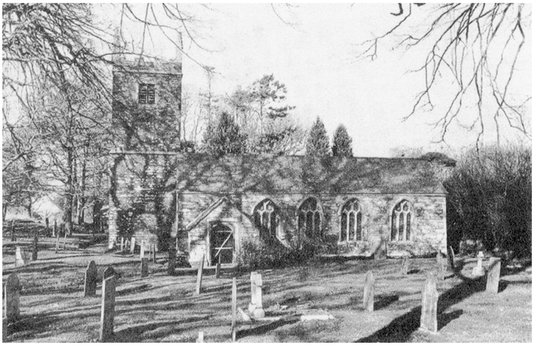
For those wishing to inspect the traditional site of the battle, look out out for a minor road on the left, just under a mile in the Lostwithiel direction, signposted Braddock Church [SX153632] Continue along this lane for a mile, reaching Braddock Church. Immediately to the south-west of the church is the ridge which in this interpretation was held by the Parliamentarians. The corresponding ridge held by the Royalists about half a mile further to the south-west, and the intervening dip, is now thickly wooded and part of the Boconnoc estate.
TOUR TWO
Stratton
[O.S. Explorer Sheet 111]
The actual battlefield is about half a mile north of Stratton village, with only limited informal parking by the roadside. However there is a free car park in Stratton itself, on the right hand side just after entering Stratton from the east along the A3072, and the battlefield is a reasonably easy 1520 minute walk from there.
Walking through the village in a westerly direction, note on the right, just before crossing the bridge over the River Neet, the Tree Inn. This reputedly was Hoptons headquarters before the battle.

