PREFACE
More than just a list of facts and figures specific to the flood of March 1936 in the Connecticut River Valley, this work seeks to provide context. Specifically, what were the early businesses or industries that supported the area, and how were they impacted by the events? These industries did not develop in a vacuum; they required support from technology and infrastructure. With that in mind, how was critical infrastructure developed and used to build those businesses and industries in that community? This book considers the history of transportation routes and systems (road, rail and waterways), communications, water supply and energy production, transmission and distribution in the context of the Connecticut River Valley from the Industrial Revolution up to the beginning of World War II.
The flood was in many regards a turning point for many of the communities. It was a time of uncertainty with the economy in shambles, national political tension and the rest of the world on the brink of war. How was that reflected on those communities, businesses and industries in the Connecticut River Valley by 1936? Further, what happened to the community after 1936 relating to the social-cultural fabric? The recovery efforts were of historic proportion and funded using newly organized and available federal monies. What happened to the communities after 1936 as it pertains to flood mitigation? Programs funded by the New Deal were a major source of recovery and rebuilding after the 1936 flood. Similarly, other federal programs played a role in the greater response to the ongoing threat of floods around the nation, and the Connecticut River damage was used in part to update the Flood Control Act with the most significant revision since its introduction in 1917.
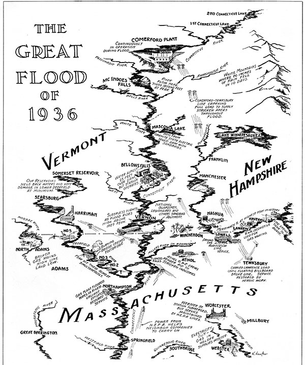
Map of infrastructure damaged during the 1936 Flood in the April 1936 issue of Contact Magazine,a trade journal of the New England Power Association. FromContact Magazine.
Boston and the metro area surrounding it at this point had ballooned and was in need of more growing support, in particular with regard to drinking water. Engineers and politicians battled over the best ways to provide these communities with an expanding network of reservoirs, created by dams and connected by aqueducts. Construction of the largest was already well underway in 1936. How were the towns that would be lost to make the Quabbin Reservoir especially hard hit by the flood?
The 1936 flood was not the first (or the last) event that would disrupt life up and down the Connecticut River Valley.
NOTE TO READERS
Sections are organized along the Connecticut River from north to south. The communities covered were primarily along the Connecticut River, but at that time, there were significant infrastructure systems along many of the more than fifty major tributaries, so those have been included as well.
ACKNOWLEDGEMENTS
Thank you to my wife, Kristen, for her endless support, confidence and love. Also, thank you to my father-in-law, Chuck Johnson, for inspiring me to consider history in the context of the work I do and my uncle Robert Comerford, PhD; a social studies teacher for decades, he was invaluable for conversation about the politics of the time. I am grateful for the friendship of Dr. Samuel Broder, a constant source of inspiration to me and reliable sounding board on all things.

