• Complain

Riaz Dean - Mapping the Great Game: Explorers, Spies and Maps in 19th-century Asia

Here you can read online Riaz Dean - Mapping the Great Game: Explorers, Spies and Maps in 19th-century Asia full text of the book (entire story) in english for free. Download pdf and epub, get meaning, cover and reviews about this ebook. City: Oxford, year: 2019, publisher: Casemate, genre: History. Description of the work, (preface) as well as reviews are available. Best literature library LitArk.com created for fans of good reading and offers a wide selection of genres:

Romance novel Science fiction Adventure Detective Science History Home and family Prose Art Politics Computer Non-fiction Religion Business Children Humor

Choose a favorite category and find really read worthwhile books. Enjoy immersion in the world of imagination, feel the emotions of the characters or learn something new for yourself, make an fascinating discovery.

Riaz Dean Mapping the Great Game: Explorers, Spies and Maps in 19th-century Asia
  • Book:
    Mapping the Great Game: Explorers, Spies and Maps in 19th-century Asia
  • Author:
  • Publisher:
    Casemate
  • Genre:
  • Year:
    2019
  • City:
    Oxford
  • Rating:
    5 / 5
  • Favourites:
    Add to favourites
  • Your mark:
    • 100
    • 1
    • 2
    • 3
    • 4
    • 5

Mapping the Great Game: Explorers, Spies and Maps in 19th-century Asia: summary, description and annotation

We offer to read an annotation, description, summary or preface (depends on what the author of the book "Mapping the Great Game: Explorers, Spies and Maps in 19th-century Asia" wrote himself). If you haven't found the necessary information about the book — write in the comments, we will try to find it.

Although the ultimate prize of the Great Game played out between Great Britain and Imperial Russia in the 19th century was India, most of the intrigue and action took place along its northern frontier in Afghanistan, Turkestan and Tibet. Maps and knowledge of the enemy were crucial elements in Britains struggle to defend the jewel in the crown.The Great Trigonometrical Survey of India had been founded in the 18th century with the aim of creating a detailed map of the country. While most people today are readily able to identify the worlds highest mountain, few know of the man, George Everest, after whom it was named, or the accomplishment that earned him this singular honor. Under his leadership, the Survey of India mapped the Great Arc, which was then lauded as one of the greatest works in the whole history of science, though it cost more in monetary terms and human lives than many contemporary Indian wars.Much of the work of the Survey was undertaken by native Indians, known as Pundits, who were trained to explore, spy out and map Central Asia and Tibet. They did this at great personal risk and with meager resources, while traveling entirely on foot. They would be the first to reveal the mysteries of the forbidden city of Lhasa, and discover the true course of Tibets mighty Tsangpo River. They were the greatest group of explorers the world has seen in recent history yet they remain the classic unsung heroes of the British Raj.The story of these extraordinary pioneers who explored much of Asia during the 19th century to fill in large portions of its map, and spy out the region for military reasons is often forgotten, but Riaz Deans vivid account of their exploits, their adventurous spirit and their tenacity in the face of great adversity, all set within the context of the Great Game and the Survey of India, will finally bring them the attention they deserve.

Riaz Dean: author's other books


Who wrote Mapping the Great Game: Explorers, Spies and Maps in 19th-century Asia? Find out the surname, the name of the author of the book and a list of all author's works by series.

Mapping the Great Game: Explorers, Spies and Maps in 19th-century Asia — read online for free the complete book (whole text) full work

Below is the text of the book, divided by pages. System saving the place of the last page read, allows you to conveniently read the book "Mapping the Great Game: Explorers, Spies and Maps in 19th-century Asia" online for free, without having to search again every time where you left off. Put a bookmark, and you can go to the page where you finished reading at any time.

Light

Font size:

Reset

Interval:

Bookmark:

Make
Pagebreaks of the print version
MAPPING THE GREAT GAME Published in Great Britain and the United States of - photo 1

MAPPING THE GREAT GAME

Published in Great Britain and the United States of America in 2019 by

CASEMATE PUBLISHERS

The Old Music Hall, 106108 Cowley Road, Oxford OX4 1JE, UK

and

1950 Lawrence Road, Havertown, PA 19083, USA

Copyright 2019 Riaz Dean

Hardcover Edition: ISBN 978-1-61200-8141

Digital Edition: ISBN 978-1-61200-8158

Kindle Edition: ISBN 978-1-61200-8158

A CIP record for this book is available from the British Library

All rights reserved. No part of this book may be reproduced or transmitted in any form or by any means, electronic or mechanical including photocopying, recording or by any information storage and retrieval system, without permission from the publisher in writing.

For a complete list of Casemate titles, please contact:

CASEMATE PUBLISHERS (UK)

Telephone (01865) 241249

Email:

www.casematepublishers.co.uk

CASEMATE PUBLISHERS (US)

Telephone (610) 853-9131

Fax (610) 853-9146

Email:

www.casematepublishers.com

All maps created by Roger Smith of Geographx. based on maps published by Matthew Edney and Geoffrey Wheeler respectively.

MAPPING THE GREAT GAME

Explorers, Spies & Maps in Nineteenth-century Asia

RIAZ DEAN

For Beth Maps 1a and 1b Central Asia Tibet and India in the nineteenth - photo 2

For Beth

Maps

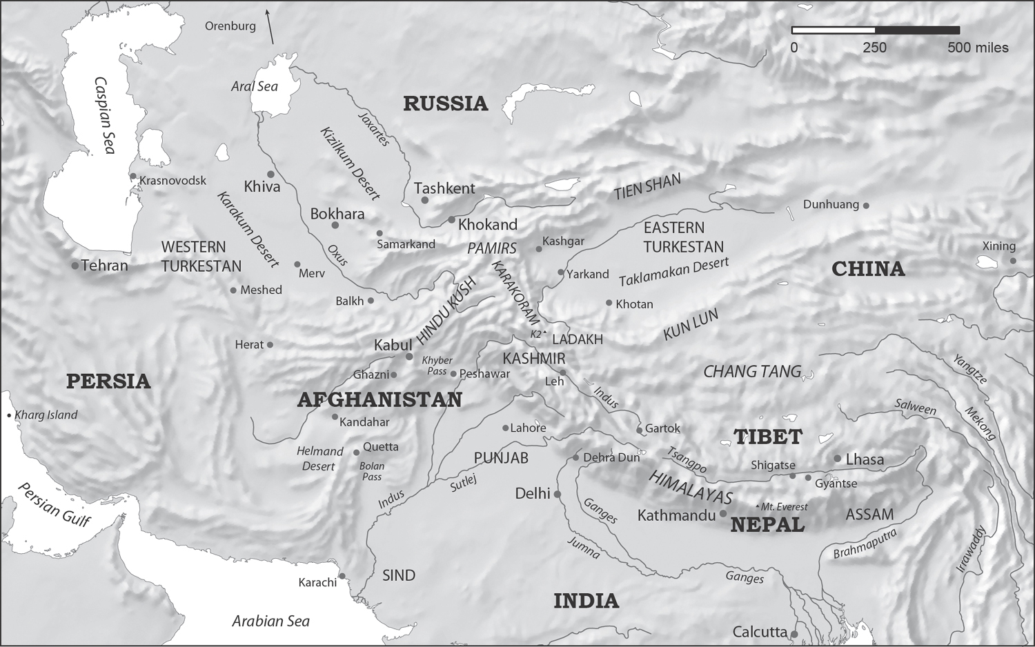
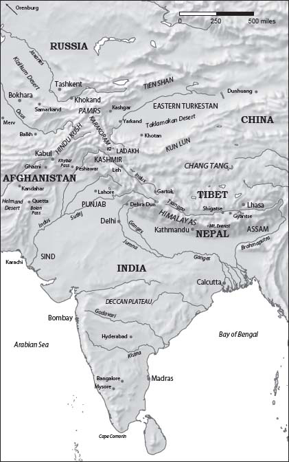
1a and 1b. Central Asia, Tibet and India in the nineteenth century

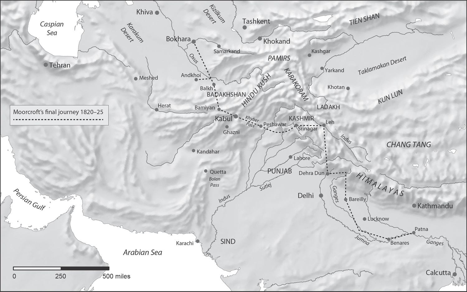
Central Asia: showing the final journey of William Moorcroft

The Triangulation of India to 1843

Northern India and Tibet: showing journeys undertaken by the Pundits

Russian conquests in Central Asia during the nineteenth century

All maps created by Roger Smith of Geographx.

based on maps published by Matthew Edney and Geoffrey Wheeler respectively.

Map 1a Central Asia Tibet and India in the nineteenth century Map 1b - photo 3

Map 1a. Central Asia, Tibet and India in the nineteenth century
Map 1b Central Asia Tibet and India in the nineteenth century Introduction - photo 4

Map 1b. Central Asia, Tibet and India in the nineteenth century

Introduction

The exploration and mapping of Asia and its subsequent carve-up by competing empires make up a fascinating part of its recent history. Most of this activity occurred during the nineteenth century, when large portions of its vast terra incognita previously left blank on maps, or simply marked Unexplored, were finally filled in. The continent would reluctantly reveal its mysteries: a myriad of people and cultures; and, inland, an extreme geography and weather, far removed from the moderating effects of any ocean. This was a time when large parts of the world and its people remained little known to Europeans, and the desire for geographical knowledgetranslated into books and mapswas an end in itself. The quest for adventure too, even at great personal risk, needed no further explanation or justification.

Although this book is set within Asia, it has a sharper focus. It will zoom in on an arc of countries on Indias northern borders. If one were to draw this arc centred on the old Mughal capital of Delhi, it would encompass, starting from the west, Persia (today Iran), then Afghanistan, Western Turkestan (later known as Russian Turkestan), Eastern Turkestan (also known as Chinese Turkestan) and finally Tibet to the east.

For Indias neighbours along the arc, this period would have an added twist. It was here that a contest of high stakes and espionage, referred to as the Great Game, was played out between two of the most powerful empires of the dayGreat Britain and Imperial Russia. Both sides eagerly sought out information about these borderlands, but some countries such as Tibet were closed off to foreigners for the best part of the century. Others such as Afghanistan and Turkestan were off limits too, but in their case this was due to the dangers travellers faced in these often lawless regions infested by bandits. Travel was even more hazardous for Christian Europeans in Muslim lands as local tribesmen considered them non-believers and they ran the real risk of being killed out of hand. Despite these difficulties, there was a desperate need for competing powers to explore and map these regions, both for offensive and defensive purposes. Indeed, the first need of an army in a strange land is a reliable map. They obtained this intelligence by employing explorers and spies, although in many cases the line between the two was blurred, or simply did not exist.

As the Great Game encompasses such a large subject area, this book will limit its scope to the defence of India against the threat of an overland invasion. Within its borders, the British could readily explore and map the entire subcontinent through the Great Trigonometrical Survey of India (the GTS). Outside these borders, they undertook this work primarily with the help of two distinct groups: a band of army officers engaged in playing the Great Game; and an obscure group of natives employed by the GTS, who would come to be known as the Pundits.

Both the Great Game and the Survey of India involved a multitude of players from several countries, from the political and military establishments. To avoid overwhelming the reader with the many names, ranks and titles of the participants involved, as well as the numerous place names and dates, our book will mention just the main ones, as far as possible.

A timeline of the key events covered, highlighting their relationship, is shown at the end of the text. But this book is not meant to be a detailed historical study of these topicsthere are specialist texts already available which do this well enough. Rather, it tells the true story of a group of extraordinary explorers, spies and map-makers, who, though perhaps forgotten today, are its real heroes.
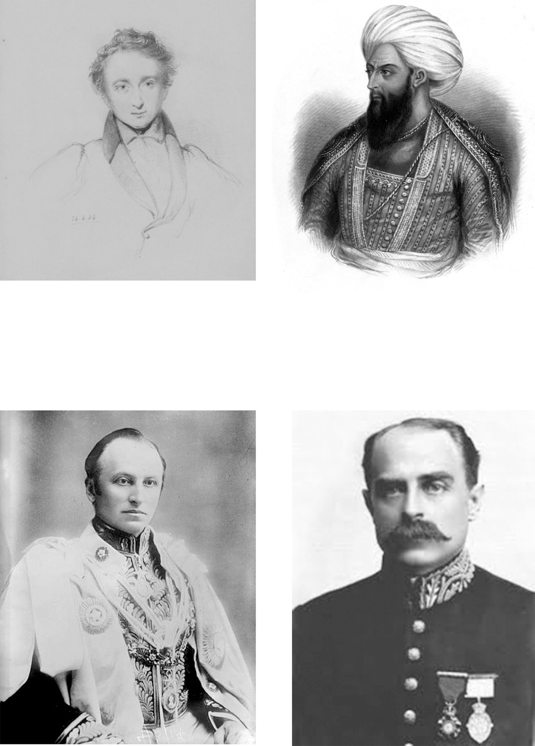
Players who shaped the Great Gameclockwise from top left Alexander Burnes - photo 5

Players who shaped the Great Gameclockwise from top left: Alexander Burnes, Dost Mohammed, Francis Younghusband and Lord Curzon.
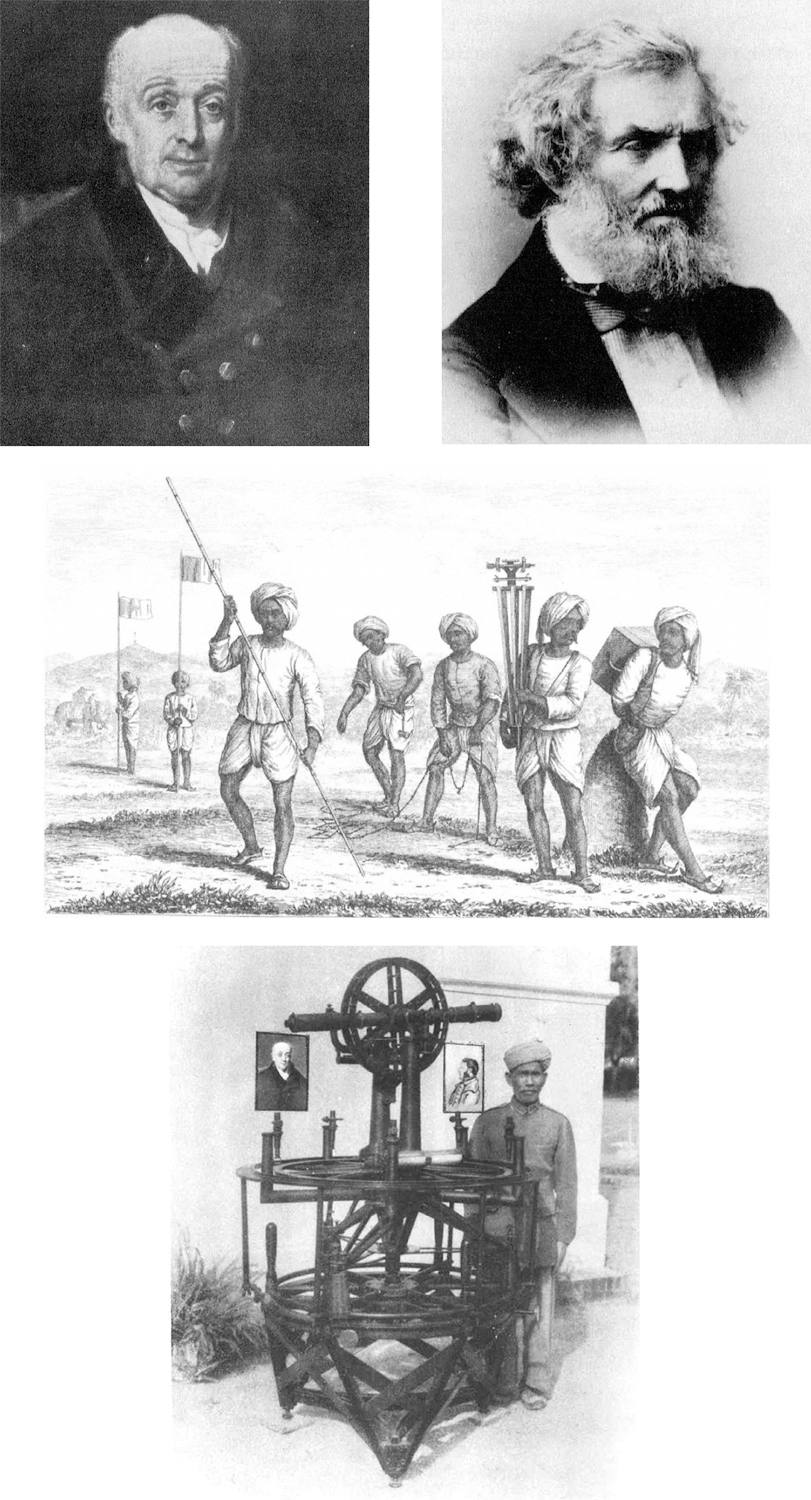
Survey of India employees and equipmentclockwise from top left William - photo 6

Survey of India employees and equipmentclockwise from top left: William Lambton, George Everest, the Great Theodolite and the Khalasis.
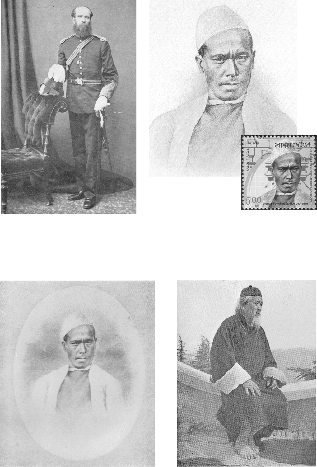
Pundits of the GTS and their founderclockwise from top left Thomas - photo 7

Pundits of the GTS and their founderclockwise from top left: Thomas Montgomerie, Nain Singh (and again on Indian postage stamp), Kintup and Kishen Singh.
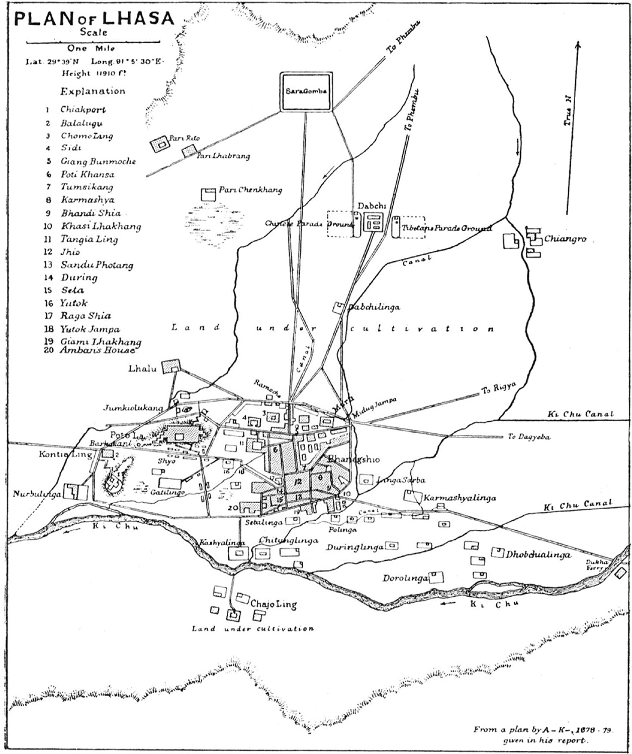
Plan of Lhasa by Kishen Singh codenamed A-K PART ONE THE GREAT GAME BEGINS - photo 8

Plan of Lhasa by Kishen Singh (codenamed A-K).

PART ONE
THE GREAT GAME BEGINS

Now I shall go far and far into the North, playing the Great Game.

Rudyard Kipling, Kim
Map 2 Central Asia showing the final journey of William Moorcroft The Early - photo 9

Map 2. Central Asia: showing the final journey of William Moorcroft
Next page
Light

Font size:

Reset

Interval:

Bookmark:

Make

Similar books «Mapping the Great Game: Explorers, Spies and Maps in 19th-century Asia»

Look at similar books to Mapping the Great Game: Explorers, Spies and Maps in 19th-century Asia. We have selected literature similar in name and meaning in the hope of providing readers with more options to find new, interesting, not yet read works.


Reviews about «Mapping the Great Game: Explorers, Spies and Maps in 19th-century Asia»

Discussion, reviews of the book Mapping the Great Game: Explorers, Spies and Maps in 19th-century Asia and just readers' own opinions. Leave your comments, write what you think about the work, its meaning or the main characters. Specify what exactly you liked and what you didn't like, and why you think so.