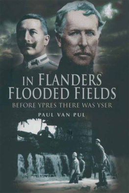
IN FLANDERS
FLOODED
FIELDS
IN FLANDERS
FLOODED
FIELDS
Before Ypres there was Yser
Paul Van Pul

First published in Great Britain in 2006 by
Pen & Sword Military
an imprint of
Pen & Sword Books Ltd
47 Church Street
Barnsley
South Yorkshire
S70 2AS
Copyright Paul A. A. Van Pul, 2006
ISBN 1 84415 492 0
The right of Paul A. A. Van Pul to be identified as Author of this Work has been
asserted by him in accordance with the Copyright,
Designs and Patents Act 1988.
A CIP catalogue record for this book is
available from the British Library
All rights reserved. No part of this book may be reproduced or transmitted in any
form or by any means, electronic or mechanical including photocopying, recording or
by any information storage and retrieval system, without permission from the
Publisher in writing.
Typeset in Sabon by
Phoenix Typesetting, Auldgirth, Dumfriesshire
Printed and bound in England by
Biddies Ltd, Kings Lynn
Pen & Sword Books Ltd incorporates the Imprints of Pen & Sword Aviation, Pen &
Sword Maritime, Pen & Sword Military, Wharncliffe Local History, Pen & Sword
Select, Pen & Sword Military Classics and Leo Cooper.
For a complete list of Pen & Sword titles please contact
PEN & SWORD BOOKS LIMITED
47 Church Street, Barnsley, South Yorkshire, S70 2AS, England
E-mail: enquiries@pen-and-sword.co.uk
Website: www.pen-and-sword.co.uk
Plerosque Beigas esse ortos a Germanis, Rhenumque antiquitus traductos propter
loci fertilitatem ibi consedisse Gallosque, qui ea loca incolerent, expulisse solosque
esse, , Teutonos Cimbrosque intra suos fines ingredi prohibuerint; qua ex re fieri,
uti earum rerum memoria magnam sibi auctoritatem magnosque Spiritus in re militari
sumerent.
Commentarii De Bello Gallico, II, 4.
Most of the Belgae had sprung from the Germans, and a long while ago had been led
across the Rhine and had settled there on account of the productivity of the soil, and
had driven out the Gauls who inhabited those regions. They were the only people
who, in the memory of our fathers, when all Gaul was ravaged, had prevented the
Teutoni and the Cimbri from entering their territory; and in consequence of the
recollection of this achievement they assumed great authority and great airs in
military matters.
Transl. J. Pearl, p.54.
The episode of the Great War described in the following pages was fought on Flemish soil in Flanders Fields. Despite the fact that the majority of the Belgian population was from Flemish origin and spoke the Flemish dialects, the Belgian establishment then was still unilingual Francophone. As an example we can quote the fact that from junior high school on, only one language was tolerated in the classroom and on the playground: French. One of the results was that most of the localities and physical features in Flanders had a French designation that appeared on all official documents. As such many are still known today in the English language.
During the same war, and for a variety of reasons, a Flemish Movement developed in which the Flemish soldiers, who formed the backbone of the front-line fighting forces, came up for equal language rights against the Francophone and military establishment.
One of the many and earlier results of this drive for Flemish emancipation was that all toponyms in Flanders reverted to their Dutch spelling. However, as this is a book in the English language we prefer to use the place-names as they were used and written at the time of the battle. Whoever does any reading or research on this tumultuous period in Western European history, be it in French or English, will inevitably run into the same but now outmoded spelling.
Since then the Kingdom of the Belgians has come a long way and evolved into a federal state with three official languages: Dutch, French and German.
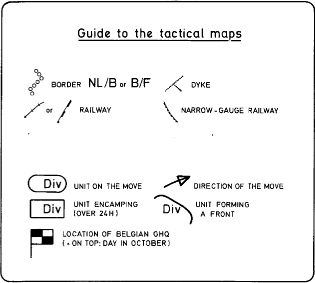
To visualize the events recounted we included twenty-nine dedicated maps, spread throughout the book. But still, to the uninitiated, the names of places, hydraulic structures, canals and rivers might be daunting. To the layperson it is indeed confusing when the Nieuport Lock is in Furnes and the Furnes Lock in Nieuport! We have therefore included in the map-index the present-day names in brackets. This will also assist readers who one day might want to check out the battlefield on a modern-day map, or even better, visit the various places that once were so gallantly defended by the three western armies against the invading enemy.
In October 1914 Flanders was still experiencing a war of movement. The tactical situation changed hour by hour. So-called action pictures are therefore rather uncommon. Everyone was still too busy advancing or retreating. These few pictures later found their way into official archives and only recently most of these institutions have started to charge for the use and publication of the pictures in their care.
Because of this potential extra financial burden we have limited the photographic material in this book to pictures that were voluntarily provided to us without charge. As such the pictures in this book have either never been published before or were once published many years ago. Where possible we got written or verbal permission to use the illustrations. Our special thanks go to all who helped us with this task.
In order to make the book enjoyable for people less familiar with military jargon, abbreviations have been kept to a minimum. Most were only used with the maps and in the bibliography. A list can also be found at the start of this book.
NOTE
The official language in Flanders and the Netherlands is one and the same: Dutch. The Flemish dialects were formerly known as Dietsch and in that sense have also close ties with Low German or Plattdeutsch.
The following account is the first in-detail, English study of the run-up to and the subsequent military floods during the first phase of the First Battle of Ypres, in Belgium better know as The Battle for the Yser river. It covers the events during the month of October 1914 in the western part of Belgium. This work was conducted without financial assistance from public or private sponsors. Only the spontaneous and unselfish cooperation of tens of individuals and institutions, in and outside Belgium, allowed us to realize this book.
It would take pages to mention and thank everyone who contributed to the result. Allow us though to name a few without whom this project would simply have been impossible. Our thanks to all for their continuing help, advice, encouragement and support.
From the first hour there were Rene Beever and Mick Laurijssens, soon followed by Staff Colonel Maurice Paulissen, then Head of the Centre for Historical Documents of the Belgian Army in Brussels and his Chief Historian Jeroen Huygelier. Also in Brussels we immensely appreciate the help of Herv Thys, son of the late Colonel Engineer Robert Thys, who opened the family archive for us.
In Nieuport we are very grateful to many people, especially the now Honorary Citizens Jules and Bertha Callenaere-Dehouck and City Curator Walter Lelivre.
Finally it was our special friend Leo Van Riel and his extensive knowledge of graphic computer work that proved to be indispensable in getting the many maps printer-ready.
NOTE
This book was first published in Dutch in 2004 under the title:
Next page
