Contents
Best Easy Day Hikes Series
Best Easy Day Hikes Carlsbad
Caverns and Guadalupe
Mountains National Parks
Stewart M. Green


An imprint of The Rowman & Littlefield Publishing Group, Inc.
4501 Forbes Blvd., Ste. 200, Lanham, MD 20706
Falcon and FalconGuides are registered trademarks and Make Adventure Your Story is a trademark of The Rowman & Littlefield Publishing Group, Inc.
Distributed by NATIONAL BOOK NETWORK
Copyright 2018 The Rowman & Littlefield Publishing Group, Inc.
TOPO! Maps copyright 2018 National Geographic Partners, LLC. All Rights Reserved.
Maps The Rowman & Littlefield Publishing Group, Inc.
All rights reserved. No part of this book may be reproduced in any form or by any electronic or mechanical means, including information storage and retrieval systems, without written permission from the publisher, except by a reviewer who may quote passages in a review.
British Library Cataloguing in Publication Information available
Library of Congress Cataloging-in-Publication Data
Names: Green, Stewart M., author.
Title: Best Easy Day Hikes Carlsbad Caverns and Guadalupe Mountains National Parks / Stewart M. Green.
Description: Guilford, Connecticut : FalconGuides, 2018.
Identifiers: LCCN 2017051073 (print) | LCCN 2017052460 (ebook) | ISBN 9781493030170 (e-book) | ISBN 9781493030163 (pbk.) | ISBN 9781493030170 (ebook)
Subjects: LCSH: Day hikingNew MexicoCarlsbad Caverns National ParkGuidebooks. | Day hikingTexasGuadalupe Mountains National ParkGuidebooks. | TrailsNew MexicoCarlsbad Caverns National ParkGuidebooks. | TrailsTexasGuadalupe Mountains National ParkGuidebooks | Carlsbad Caverns National Park (N.M.)Guidebooks. | Guadalupe Mountains National Park (Tex.)Guidebooks.
Classification: LCC GV199.42.N62 (ebook) | LCC GV199.42.N62 G834 2018 (print) | DDC 796.510978dc23
LC record available at https://lccn.loc.gov/2017051073
 The paper used in this publication meets the minimum requirements of American National Standard for Information SciencesPermanence of Paper for Printed Library Materials, ANSI/NISO Z39.48-1992.
Printed in the United States of America
The author and Rowman & Littlefield assume no liability for accidents happening to, or injuries sustained by, readers who engage in the activities described in this book.
Contents
Introduction
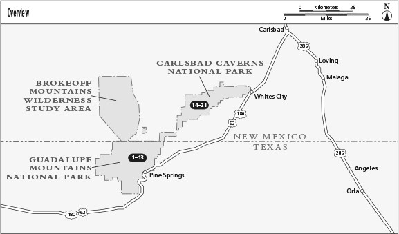
Guadalupe Mountains and Carlsbad Caverns National Parks, lying along the Texas and New Mexico border, are two parklands that offer different hiking experiences. Guadalupe Mountains is a rugged area of high mountains and deep canyons that are traversed by over 80 miles of trails. The park offers trails up two iconic Texas landmarksGuadalupe Peak, the states highest point, and McKittrick Canyon, sometimes called the most beautiful spot in Texas. Carlsbad Caverns offers spectacular hikes into the famous cave as well as trails that explore surrounding canyons. Best Easy Day Hikes Carlsbad Caverns and Guadalupe Mountains National Parks describes twenty-one of the best and most accessible trails for the casual hiker in search of adventure.
If you are on a tight schedule or want to do a short, excellent hike in a scenic park area, this book allows you to quickly select a hike suited to your abilities and time constraints. Most of the hikes are between 1 and 5 miles long. Also included are easy walks for families and barrier-free trails that are wheelchair accessible. All of the trailheads are easily accessible by car and have parking lots.
The hikes are rated by difficulty from easiest to most challenging. Check the listing to help you decide which hike is best for you and your party.
Weather
All the hikes in Guadalupe Mountains and Carlsbad Caverns National Parks lie in the northern Chihuahuan Desert, one of North Americas five great deserts. This high desert is wetter and cooler than other deserts like southern Arizonas Sonoran Desert. The best hiking months are September and October and April and May, although summers are generally pleasant at Guadalupe Mountains National Park with its high elevations.
Temperature and precipitation at Guadalupe Mountains National Park greatly varies depending on elevation, which ranges from 3,000 feet at Salt Basin to 8,751 feet atop Guadalupe Peak, the highest point in Texas. Hiking is good year-round, with cool temperatures between November and March and warm temperatures from April through October. Summer temperatures are hot in the sun, with daily highs averaging 88F in June and July at Pine Springs. The shoulder months of April and October are perfect for hiking with highs averaging 73F. Most of the parks 17.4 inches of annual precipitation falls during the summer monsoon season from June through September. Watch for heavy thunderstorms accompanied by lightning during the summer. Late fall and winter offers good hiking weather but expect high winds over 70 mph, especially at high elevations. Snow also falls in the colder months, but usually melts except on north-facing slopes. Its best to dress in layers when hiking, as well as wear a hat and sunscreen, and carry plenty of water and sports drinks.
Carlsbad Caverns National Park, with elevations ranging between 3,600 feet and 6,500 feet, has a semiarid climate with hot summers and mild, dry winters. The best hiking months are between October and April. Summer high temperatures are in the 90s and low 100s, with an average high in June and July of 90F. Most of the parks annual 14.9 inches of precipitation falls in heavy thunderstorms between July and September during the monsoon season. Plan summer hikes for the early morning or evening when temperatures are much cooler than the middle of the day. Almost no shade is found on any of the surface hikes, so bring plenty of water and sports drinks, and wear sunscreen and a hat for protection.
The cavern hikes are cooler than surface trails, with a year-round temperature of 56F on the described trails and humidity varying between 87 percent in winter to 95 percent in summer. Most hikers are comfortable wearing a light sweater or sweatshirt.
Types of Hikes
Loop: A loop hike starts and ends at the same trailhead via different routes, although part of the hike may retrace the same route for a short distance.
Out and back: An out-and-back hike reaches a specific destination and returns via the same route. Distances given in the text are specified as one-way (just the out portion) or round-trip (out and back).
Lollipop: A loop hike that follows the same route out and back at its start to a loop trail, forming a shape like a kids lollipop.
Trail Maps
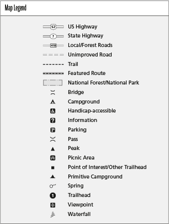
Maps of all hiking trails are included in this book. It is recommended you supplement these with more detailed maps. USGS topographic maps and National Geographic Trails Illustrated maps are listed for each hike, and both are good options. Hiking maps for popular trails may be available at visitor centers. GPS coordinates are listed for parking areas, trailheads, major trail junctions, points of interest, and turn-around points for all the hikes.






 The paper used in this publication meets the minimum requirements of American National Standard for Information SciencesPermanence of Paper for Printed Library Materials, ANSI/NISO Z39.48-1992.
