About the Author
Stuart Haines is a walker, mountain lover, guidebook writer, project manager and occasional viticulturalist. His explorations of the remoter corners of central Italy began in 2004, following many years of climbing and adventuring in the Alps, North America and his native UK. Since 2007 he has been based between Bristol, England, and Casa La Rocca, the country house in the heart of Abruzzo that he renovated with his partner, Hil. The house offers self-catered accommodation for visitors to the region and is the base for Stuarts support service for walkers, cyclists and everyone who comes to discover the grandeur of Abruzzo for themselves route advice, drop-offs and pick-ups, pack transport, overnight booking and the organic Montepulciano dAbruzzo house wine all available under one roof www.casalarocca.it.
WALKING IN ABRUZZO
GRAN SASSO, MAIELLA AND ABRUZZO NATIONAL PARKS, AND SIRENTE-VELINO REGIONAL PARK
by Stuart Haines
JUNIPER HOUSE, MURLEY MOSS,
OXENHOLME ROAD, KENDAL, CUMBRIA LA9 7RL
www.cicerone.co.uk
Stuart Haines 2019
Second edition 2019
ISBN 9781783626885
First edition 2011
ISBN 9781852845766
Printed in China on behalf of Latitude Press Ltd
A catalogue record for this book is available from the British Library.
All photographs are by the author unless otherwise stated.
 Route mapping by Lovell Johns www.lovelljohns.com
Contains OpenStreetMap.org data OpenStreetMap contributors, CC-BY-SA. NASA relief data courtesy of ESRI
Dedication
For Hil
Updates to this guide
While every effort is made by our authors to ensure the accuracy of guidebooks as they go to print, changes can occur during the lifetime of an edition. Any updates that we know of for this guide will be on the Cicerone website (www.cicerone.co.uk/978/updates), so please check before planning your trip. We also advise that you check information about such things as transport, accommodation and shops locally. Even rights of way can be altered over time.
The route maps in this guide are derived from publicly available data, databases and crowd-sourced data. As such they have not been through the detailed checking procedures that would generally be applied to a published map from an official mapping agency, although naturally we have reviewed them closely in the light of local knowledge as part of the preparation of this guide.
We are always grateful for information about any discrepancies between a guidebook and the facts on the ground, sent by email to updates@cicerone.co.uk or by post to Cicerone, Juniper House, Murley Moss, Oxenholme Road, Kendal, LA9 7RL.
Register your book: To sign up to receive free updates, special offers and GPX files where available, register your book at www.cicerone.co.uk
Front cover: Monte Ocre ridge looking towards Monte Cagno and Monte Sirente (Walk 37)
CONTENTS
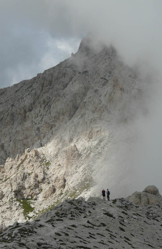
Monte Prena from Vado di Feruccio (Walk 12)

Corno Grande group from Monte di Mezzo (Walks 20)

Entering the open valley behind Monte Ocre (Walk 37)
INTRODUCTION

Campo Imperatore from Sella di Monte Aquila (Walks 14 and 16)
Its 7.30pm. You are standing on the tower of the isolated medieval castle, Rocca Calascio, set dramatically at 1500m on a narrow ridge in the heart of Abruzzo. Fading light is softening the seemingly endless ridges, peaks and valleys that lie in every direction; the silence is underlined by occasional barking from a hamlet below.
One other building stands nearby. The beautiful octagonal church of Madonna della Piet is isolated against the dramatic south east face of Corno Grande, the apex of the Apennines, 16km to the north and 1500m higher still.
Its early June. The day has been hot and sunny, although the hours on the trail were eased by a gentle breeze rising from the Adriatic. The air is still warm but its time for a light sweater.
This is the centre of the Gran Sasso National Park. The peak and west flank of Corno Grande blaze in the sinking sun while the steep, stark east wall has fallen into shadow. You think about yesterday, when you stood on that summit and fed sweetcorn kernels to the choughs. You felt that you could see from one side of Italy to the other, while all the mountains of Abruzzo were ranged around.
Now, slanting rays light up the ancient village of Carapelle Calvisio, lying on a lower ridge to the south. The forest has darkened, providing a fine background to the glowing tones of the beautiful old buildings.
The peace is extraordinary and the view immense. It is easy to understand why 10th-century barons chose this place to raise their fortress the highest and surely the most picturesque in Italy.

Corno Piccolo from the west ridge of Corno Grande (Walk 14)
The soft clatter of an old tractor draws your gaze to the valley floor. It is moving slowly down a white lane through strips of lentil and potato fields, along the route of the famous Sentiero Italia a footpath that runs from the Dolomites to the tip of Sicily. Not that you can imagine undertaking such a walk when there is so much to be explored in just the landscape you can see!
Imperceptibly, the far ridges turn to abstract layers of green, blue and purple, capped by the reddening sky. The peaks of the Maiella and the Abruzzo national parks, way south, grow a little larger as they become silhouettes on the horizon. Wispy cloud has gathered on the shoulders of Monte Amaro, the crown of the Maiella massif and, at 2800m, the regions second highest point. You look away and then back it has gone as quickly as it formed.
The Peligna basin, separating the three national parks, lies below the steep west slopes of the Maiella. Its too dark now to make out Sulmona, the main town of central Abruzzo, but tomorrow you will walk towards it. In two days time you will arrive there, tired and a little regretful, to spend your last night before catching the train back to Rome.







 Route mapping by Lovell Johns www.lovelljohns.com


