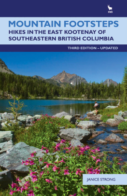
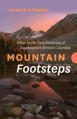
Strong - Mountain footsteps: hikes in the East Kootenay of southeastern British Columbia
Here you can read online Strong - Mountain footsteps: hikes in the East Kootenay of southeastern British Columbia full text of the book (entire story) in english for free. Download pdf and epub, get meaning, cover and reviews about this ebook. year: 2010, publisher: Rocky Mountain Books, genre: Home and family. Description of the work, (preface) as well as reviews are available. Best literature library LitArk.com created for fans of good reading and offers a wide selection of genres:
Romance novel
Science fiction
Adventure
Detective
Science
History
Home and family
Prose
Art
Politics
Computer
Non-fiction
Religion
Business
Children
Humor
Choose a favorite category and find really read worthwhile books. Enjoy immersion in the world of imagination, feel the emotions of the characters or learn something new for yourself, make an fascinating discovery.

- Book:Mountain footsteps: hikes in the East Kootenay of southeastern British Columbia
- Author:
- Publisher:Rocky Mountain Books
- Genre:
- Year:2010
- Rating:4 / 5
- Favourites:Add to favourites
- Your mark:
Mountain footsteps: hikes in the East Kootenay of southeastern British Columbia: summary, description and annotation
We offer to read an annotation, description, summary or preface (depends on what the author of the book "Mountain footsteps: hikes in the East Kootenay of southeastern British Columbia" wrote himself). If you haven't found the necessary information about the book — write in the comments, we will try to find it.
This edition of one of Rocky Mountain Books bestselling hiking guides contains the latest updates to routes, trails and roads in the areas around Cranbrook, Kimberley, Creston, Invermere, Radium and Fernie, located between the Rocky Mountains in the east and the Purcell Mountains in the west, including the Akamina Kishinena, Top of the World, Elk Lakes, St. Marys Alpine and Bugaboo Glacier Provincial Parks. This volume will entice hikers of all abilities. As with previous editions, readers will continue to appreciate the authors detailed descriptions and personal anecdotes, complete with colour maps and photos, related to one of the most stunning areas in western Canada.
Janice Strong continues to enhance the outdoor experience for hiking enthusiasts from across the country and around the world.
Strong: author's other books
Who wrote Mountain footsteps: hikes in the East Kootenay of southeastern British Columbia? Find out the surname, the name of the author of the book and a list of all author's works by series.


Mountain footsteps: hikes in the East Kootenay of southeastern British Columbia — read online for free the complete book (whole text) full work
Below is the text of the book, divided by pages. System saving the place of the last page read, allows you to conveniently read the book "Mountain footsteps: hikes in the East Kootenay of southeastern British Columbia" online for free, without having to search again every time where you left off. Put a bookmark, and you can go to the page where you finished reading at any time.
Font size:
Interval:
Bookmark:
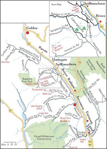
Northern Purcell Mountains Road Map

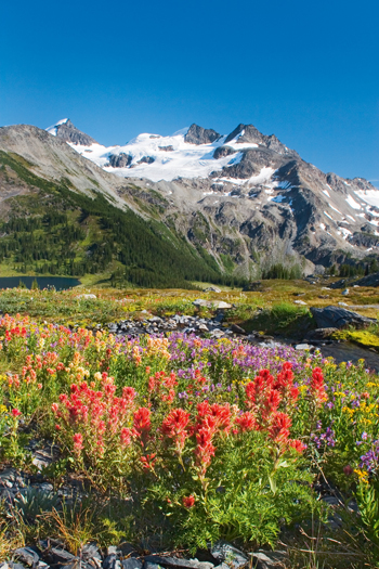
Shhh... were going to Silent Pass, although the mosquitoes ensured it was never silent for long. Absorbed in the mountain grandeur, we spent days in the open alpine of the high country, exploring flower meadows and meltwater tarns. We appreciated the views of the Spillimacheen Glacier and many other nearby glacier-draped mountains.
All is still in the high mountains, except the water laden with glacial silt that grinds away the high Purcell Mountains. Waterfalls tumble and hiss off the ancient ice.
Silent Pass is a land of fabulous beauty and scenic diversity, and its appealing and diverse landscape invites explorations for a day or two. Rugged high peaks etched by receding glaciers line both sides of the valley. Wildflower meadows bloom for only about six weeks during the short, high-elevation summers. Myriad colours and shapes blanket the hillsides, and small creeks flow across the moss-covered alpine areas.
Spillimacheen Glacier looks down onto Silent Pass and the cascading runoff pours down into both East Kootenay and West Kootenay rivers. A short ridgewalk up from Silent Pass brings you down to the edge of the ice.
Silent Pass is a low-forested pass, and just north of the pass is the little gem called Silent Lake. This tiny, 500-metre-wide lake shimmers with reflections of the glacier, its shore rimmed in low, sloping meadows.
Silent Mountain, at 2621 m (8,600 ft.), stands 2.5 km northwest of Silent Pass. The boundary of Glacier National Park is only 4 km to the west. You can hike west 2.7 km up and down slopes and across flowered meadows and peer at peaks clad in glaciers towering over 3200 m (10,500 ft.) in Glacier National Park. Also from the meadow viewpoints, the slopes plunge below you 900 m (3,000 ft.) into the deep and steep-sided Beaver and Duncan rivers; separating the Selkirk Mountains from the Purcell Mountains.
A day hike from Silent Lake up to the base of the Spillimacheen Glacier has a short section of moderate scrambling. Hike up alpine meadows on the east side of the lake. As you approach the ridge, angle slightly to the left (north) for easier scrambling. The alpine ridge is at 2500 m (8,200 ft.). Hike south along the ridge and descend to reach the broken, lowest edge of the Spillimacheen Glacier. At the end of the ridge, near the melting edges of the ice, hike gradually west along the bedrock slopes, exploring the meltwater tarns. Backtrack up to the ridge or make your way north along the talus sidehill (very steep in places) back to Silent Lake.
Rating: moderate
Time: day hike 2 hours backpack 2 or 3 days
Distance: 4.3 km
Elevation gain: 443 m (1,460 ft.)
Silent Lake: 2042 m (6,760 ft.)
Silent Pass: 2073 m (6,800 ft.)
Trail: popular trail; fair condition; small creek crossings; steep trail to alpine lake by a glacier
Maps: 82N/3 Mount Wheeler (NAD83); 82N/2 McMurdo (NAD83)
Road: any vehicle, but washboards, rough spots and rocky sections
The town of Parson is 67 km north of Radium on Highway 95. Spillimacheen FS Road is busy with commercial logging traffic, and recreation drivers must be aware of fully loaded logging trucks and heavy equipment on the road during the spring, summer and autumn.
0 km: Turn west from Highway 95, N57891-E25300, just north of the Columbia Valley Elementary School to the signed Parson River Road. Cross the Columbia River bridge from the town of Parson. Spillimacheen FS Road has many side branches; stay on main FS road. (In the town of Spillimacheen, do not turn off the highway onto Westside Road. Keep heading north for another 28 km.)
17 km: Continue straight on Spillimacheen Creek FSR, (dont take left fork to Bobbie Burns)
23.4 km: Continue straight (left fork leads to nice Forest Service Recreation campsites Summit Lake, Loon Lake just after 23 km sign).
36 km: Continue straight (38 km sign).
46.3 km: Turn left, south (first left after 45 km sign), onto the signed McMurdo Creek FS road, N64263-E94155.
Reset odometer to 0.
McMurdo Creek FS Road is rough, but a sturdy car may be able to travel it.
0 km: Junction of Spillimacheen River FS Road and McMurdo Creek FS Road. Cross bridge. Another three crossings on good bridges at 1.7 km, 7.1 km (53 km sign) and 8.8 km.
3.7 km: Mudslide area, 2008 mudslide, but may slide again following heavy storms.
10.4 km: Park at end of the road (after 56 km sign), N57239-E88608, at 1600 m (5,244 ft.). Bridge pulled out.
0 km: Hike south from the parking spot at the end of McMurdo Creek FS Road.
900 m: Road forks. Take right fork to Silent Pass. (The left fork leads to the public-use McMurdo Cabin: see .)
2.2 km: The road wraps around the end of the valley in a 600-m (2,000-ft.) switchback.
2.7 km: End of road; the trail heads up to the right (west) into the forest.
3.3 km: Cross riparian areas and a couple of small bridges. The trail climbs steeply for 106 m (350 ft.), up an avalanche slope.
4.3 km: The trail ascends gradually through subalpine meadows to Silent Lake, N55100-E87200.
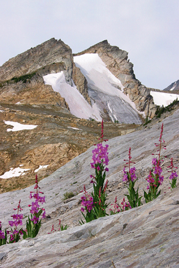
Silent Pass below the Spillimacheen Glacier has small areas that are vibrant with summer wildflowers. Silent Lake is in the background.
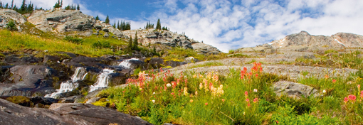
Flowers and small creeks in the high alpine by Silent Pass.
The McMurdo Cabin is an old one-room log cabin built in the early 1900s as a mining camp for the works near the Spillimacheen Glacier. The small cabin is in mature spruce forest by a marshy meadow. The marsh is closed to ATVs.
The Columbia Valley Hut Society maintains and coordinates reservations for overnight use of this public hut. The hut is used in summer for access into the area south of Spillimacheen Glacier International Basin and by hikers exploring the small valley at the headwaters of McMurdo Creek. In winter, the cozy cabin is shelter to backcountry skiers. Snowmobiles and ATVs are not permitted south of the cabin.
also.
A road continues south of the cabin in a narrow valley toward the old mine site. The road follows the steeply gouged creek channel and ascends into the forest. At 1.5 km south of the cabin, the terrain steepens and is rugged, untracked alpine beyond the end of the road.
Spillimacheen FS Road is generally not plowed and there is a snowmobile staging area at about 21 km. Snowmobilers ride over 30 km up to the cabin. Beyond the cabin the area is closed to motorized use, and skiers reach into the high country slopes.
Font size:
Interval:
Bookmark:
Similar books «Mountain footsteps: hikes in the East Kootenay of southeastern British Columbia»
Look at similar books to Mountain footsteps: hikes in the East Kootenay of southeastern British Columbia. We have selected literature similar in name and meaning in the hope of providing readers with more options to find new, interesting, not yet read works.
Discussion, reviews of the book Mountain footsteps: hikes in the East Kootenay of southeastern British Columbia and just readers' own opinions. Leave your comments, write what you think about the work, its meaning or the main characters. Specify what exactly you liked and what you didn't like, and why you think so.