Bill Cunningham - Best Easy Day Hikes Joshua Tree National Park
Here you can read online Bill Cunningham - Best Easy Day Hikes Joshua Tree National Park full text of the book (entire story) in english for free. Download pdf and epub, get meaning, cover and reviews about this ebook. year: 2019, publisher: Falcon Guides, genre: Home and family. Description of the work, (preface) as well as reviews are available. Best literature library LitArk.com created for fans of good reading and offers a wide selection of genres:
Romance novel
Science fiction
Adventure
Detective
Science
History
Home and family
Prose
Art
Politics
Computer
Non-fiction
Religion
Business
Children
Humor
Choose a favorite category and find really read worthwhile books. Enjoy immersion in the world of imagination, feel the emotions of the characters or learn something new for yourself, make an fascinating discovery.

- Book:Best Easy Day Hikes Joshua Tree National Park
- Author:
- Publisher:Falcon Guides
- Genre:
- Year:2019
- Rating:4 / 5
- Favourites:Add to favourites
- Your mark:
Best Easy Day Hikes Joshua Tree National Park: summary, description and annotation
We offer to read an annotation, description, summary or preface (depends on what the author of the book "Best Easy Day Hikes Joshua Tree National Park" wrote himself). If you haven't found the necessary information about the book — write in the comments, we will try to find it.
Best Easy Day Hikes Joshua Tree National Park includes detailed maps and concise descriptions for twenty easy-to-follow hikes in gorgeous Joshua Tree National Park. From the High View Nature Trail to Silver Bell Mine, you will discover some of the best desert hiking California has to offer.
Bill Cunningham: author's other books
Who wrote Best Easy Day Hikes Joshua Tree National Park? Find out the surname, the name of the author of the book and a list of all author's works by series.

Best Easy Day Hikes Joshua Tree National Park — read online for free the complete book (whole text) full work
Below is the text of the book, divided by pages. System saving the place of the last page read, allows you to conveniently read the book "Best Easy Day Hikes Joshua Tree National Park" online for free, without having to search again every time where you left off. Put a bookmark, and you can go to the page where you finished reading at any time.
Font size:
Interval:
Bookmark:
Polly and Bill Cunningham are lifelong hikers and wilderness advocates. They have collaborated on several FalconGuides, including Wild Utah, Hiking New Mexicos Gila Wilderness, Hiking New Mexicos Aldo Leopold Wilderness, Best Easy Day Hikes Joshua Tree, Hiking Californias Desert Parks, Hiking Mojave National Preserve, Hiking Joshua Tree National Park, Hiking Death Valley National Park, and Hiking Anza-Borrego Desert National Park.
Bruce Grubbs is an avid camper, backpacker, hiker, mountain biker, and cross-country skier who has been exploring the American desert for over thirty years. A professional outdoor writer and photographer, he has written many previous FalconGuides, including Hiking Arizona. He lives in Flagstaff, Arizona.
The High View Trail, as the name suggests, provides panoramic views of the parks western section. The gently graded climb offers plenty of opportunities to pausesome with a nearby benchto enjoy the vista. An interpretive brochure is available at the Black Rock Ranger Station.
Distance: 1.3-mile loop
Approximate hiking time: 2 hours
Difficulty: Moderate due to a 320-foot elevation gain
Trail surface: Sandy earth with some rocky steps
Maps: Trails Illustrated Joshua Tree National Park map; USGS Yucca Valley South
Trailhead facilities: The parking area is at the end of a short dirt road. A vault toilet is available at the adjacent Black Rock Campground.
Finding the trailhead: From CA 62 in Yucca Valley, turn south on Avalon Avenue and drive 0.7 mile to where it becomes Palomar Avenue. Continue south on Palomar Avenue for 0.2 miles and turn left on Joshua Lane. Take Joshua Lane for 1 mile to a T intersection at San Marino Drive. Turn right and go 0.3 mile to Black Rock Road. Turn left on Black Rock Road and drive south 0.5 mile to the parks entrance. Immediately before the entrance, turn right (west) onto a dirt road and go 0.8 mile to the parking area. GPS: N34 4.579' / W116 23.966'
The Hike
This nature trail travels to the top of a hill, providing a view over the Yucca Valley and the northern reaches of the park. There is a register at the summit at 0.5 mile, as well as a bench. The 1.3-mile-long trail follows a relatively gentle route as it climbs 320 feet. Numbered sites line the trail; brochures are available at the Black Rock Ranger Station in the adjacent campground. Even without a brochure in hand this is a delightful overview of Joshua Tree, both the town and the park.
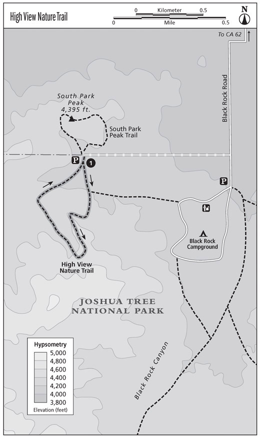
From the parking area, go directly south to begin the hike. The climb to the peak is moderated by the winding pathway. The descent leads down the back side of the peak, then curves around to the north to return to the parking lot. For those with tender knees, the longer descent allows for a gentler grade and is easier on your joints than a shorter route down. Also, the back side of the peak gives you a real flavor of desert solitude. No automobiles, no roads, no bustle, no noise.
If youre staying at the nearby Black Rock Campground, a hilly but very scenic route connects the campground with the nature trail. It leaves from the top of the campground loop above the ranger station and enters the nature loop in its first section. Although clearly marked, this alternate route to the campground has an aura of wilderness. On our loop hike from the campground, we spotted two coyotes hunting for rabbits in the middle of the afternoon. This extension to the peak hike adds 1 mile to the total distance.
Miles and Directions
0.0 Start by heading directly south from the parking area.
0.5 Reach the summit; go straight ahead to continue the loop.
1.3 Arrive back at the trailhead.
From the summit you will enjoy sweeping vistas of the northwestern section of the park as well as the sea of towns beyond the park boundaries. The value of protecting land through park designation is nicely illustrated by this juxtaposition of uses.
Distance: 0.7-mile loop
Approximate hiking time: 1 hour
Difficulty: Moderate due to a 250-foot elevation gain
Trail surface: Sandy earth with some rock steps
Maps: Trails Illustrated Joshua Tree National Park map; USGS Yucca Valley South
Trailhead facilities: The parking area is at the end of a dirt road. A vault toilet is in the nearby Black Rock Campground.
Finding the trailhead: From CA 62 in Yucca Valley, take Avalon Avenue south for 0.7 mile to where it becomes Palomar Avenue. Continue south on Palomar Avenue for 2.3 miles to Joshua Lane. Turn left onto Joshua Lane and drive 1 mile to the T intersection with San Marino Drive. Turn right on San Marino Drive and go 0.3 mile to its end at Black Rock Road. Turn left (south) on Black Rock Road and go 0.5 mile to the park entrance. Immediately before the entrance, turn right (west) on the dirt road. Follow it for 0.8 mile to the parking area. The unsigned trail to the peak begins at the northwest corner of the parking area. GPS: N34 4.579' / W116 23.966'
The Hike
Although this short loop hike lies just outside Joshua Tree National Parks northern boundary, it provides a sweeping view of the parks northwestern section and the town of Joshua Tree in the valley below.
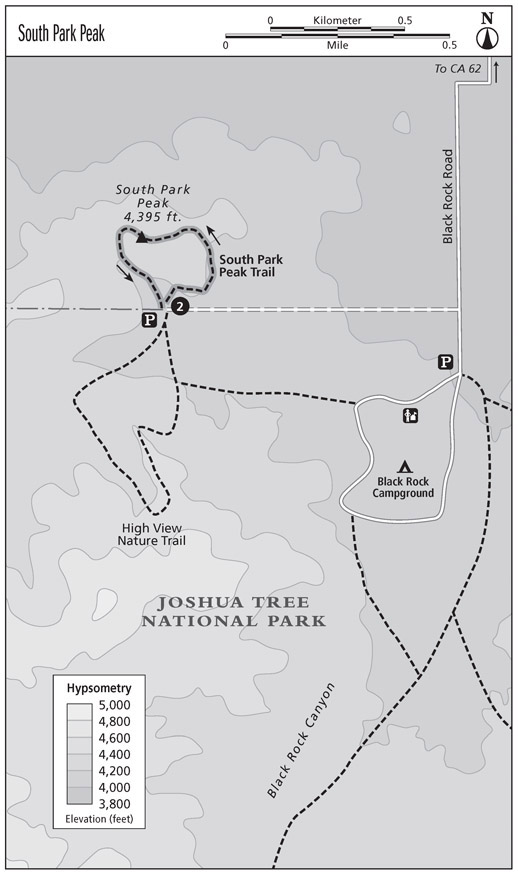
Take the right-hand trail north of the parking area. This gentle peak climb begins as an easy dirt trail. At 0.2 mile there is a comfortable bench where you can enjoy the excellent view. Another bench adorns the summit at 0.4 mile. The trail between the benches is steeper and rockier than the section from the parking area. Pausing to enjoy the view is always an option.
The peak boasts quite a register. With a concrete pedestal and a Plexiglas box, it is an impressive item. The stack of registers within the box makes great reading while you are resting on the bench. Lots of literary visitors climb South Park Peak.
Yucca Valleys sprawl, with its subdivisions closing in on the park, swirls on the northwhile to the south lies the vast open space of Joshua Tree National Park. As many that signed the register noted, this sight is confirmation that national park status is the best protection for desert areas, particularly near expanding population centers.
Follow the trail past the register box for your return. The trail descends to the wash on the back side of the peak and ends at the parking area.
Miles and Directions
0.0 Start by going north, bearing to your right.
0.2 Reach a park bench.
0.4 Arrive on the summit of South Park Peak; continue on the loop trail past the register box.
0.7 Arrive back at the trailhead.
This nature trail follows a broad desert wash on the northern edge of the Wonderland of Rocks area of the park. The interpretive signs emphasize desert vegetation found in such drainages.
Distance: 0.6-mile loop
Approximate hiking time: Less than 1 hour
Difficulty: Easy
Trail surface: Sandy wash with some scattered rocks
Maps: Trails Illustrated Joshua Tree National Park map; USGS Indian Cove
Trailhead facilities: The parking area is at the western edge of the Indian Cove Campground. There are vault toilets at the campground.
Font size:
Interval:
Bookmark:
Similar books «Best Easy Day Hikes Joshua Tree National Park»
Look at similar books to Best Easy Day Hikes Joshua Tree National Park. We have selected literature similar in name and meaning in the hope of providing readers with more options to find new, interesting, not yet read works.
Discussion, reviews of the book Best Easy Day Hikes Joshua Tree National Park and just readers' own opinions. Leave your comments, write what you think about the work, its meaning or the main characters. Specify what exactly you liked and what you didn't like, and why you think so.