E DITED BY B RIDGET B. S TRIKER
FOREWORD BY DONALD E. CLARE JR.
CONTRIBUTIONS BY JENNIFER GREGORY,
C. ADAM HARKE, MELINDA SARTWELL
& LAURIE WILCOX

Published by The History Press
Charleston, SC 29403
www.historypress.net
Copyright 2010 by Bridget B. Striker
All rights reserved
First published 2010
e-book edition 2011
ISBN 978.1.61423.126.4
Library of Congress Cataloging-in-Publication Data
Striker, Bridget.
Lost river towns of Boone County / Bridget Striker.
p. cm.
Includes bibliographical references.
print edition ISBN 978-1-59629-472-1
1. Boone County (Ky.)--History, Local. 2. Cities and towns--Kentucky--Boone County
-History. 3. Historic sites--Kentucky--Boone County. 4. River life--Kentucky--Boone
County--History. I. Title.
F457.B65S26 2010
976.9363--dc22
2010024443
Notice: The information in this book is true and complete to the best of our knowledge. It is offered without guarantee on the part of the author or The History Press. The author and The History Press disclaim all liability in connection with the use of this book.
All rights reserved. No part of this book may be reproduced or transmitted in any form whatsoever without prior written permission from the publisher except in the case of brief quotations embodied in critical articles and reviews.
Contents
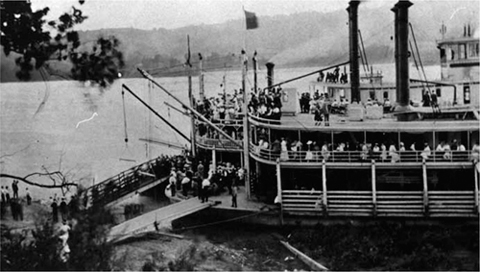
Loading passengers at Petersburg for the trip to the Fernbank Dam celebration, September 4, 1911. Fernbank Dam was located near Taylorsport in northern Boone County. Courtesy of the Petersburg Album Collection, Boone County Public Library.
Foreword
It is always such a thrill to rediscover something that has been lost in time. Its an even bigger thrill when that thing is a town, especially a Boone County, Kentucky town along the Ohio River.
The entire northern and western boundary of Boone County is the Ohio River, 35 beautiful miles of it. For the past twelve thousand years, human beings have been traveling the waters of this 981-mile Ohio River, and for twelve thousand years, they have passed what is now Boone County, Kentucky.
The Paleo-Indians, the name given to the very first Native American culture to inhabit Boone County, began their nomadic lives of following their main food source, the megafauna of the Pleistocene era, in North America about 10,000 BC. The mammoths and mastodons followed their food and water sources down the glaciated midsection of the continent, leading the Paleo-Indians through Boone County and along the Ohio River, the natural corridor most conducive to travel. And these early inhabitants made stops along the way and lived for periods of time along the river. Not quite in towns per se, but these were the embryonic beginnings of specific sections of settlement by human beings.
Man and animal continued to travel this very same route in search of subsistence and sustenance throughout the next cultural period, that of the Archaic Indian. Still mainly hunters, these early inhabitants were also gatherers, utilizing plants, nuts, fruits and grasses to complement their diet. The Archaics were not quite as nomadic as their predecessors, and they had seasonal camps and temporary settlements along the river. There were subsections of the Archaic, called Early, Middle and Late Archaic Periods, covering a span of about six thousand years. Archaic Indians of each of these periods spent time here in Boone County, living for periods on the banks of the river. The settlements were still not quite towns but were getting closer.
The next Native American cultural affiliationthe Woodland period Indians, also subclassified into Early, Middle and Latedates between the years 1000 BC and AD 1000. It was within this period that the use of pottery appeared. Later in the period, earthworks and burial mounds began to dot the Boone County landscape. Again, there is archaeological evidence of seasonal camps and temporary gathering spots, but no large permanent village sites.
It was during the last periodthe Late Prehistoric periodthat we find evidence of more permanent settlements and a change toward a sedentary and agrarian lifestyle. This is also called the Fort Ancient period. It is represented by village sites along the river and creeks that are of a more permanent makeup, indicating continuous habitation. Petersburg sits atop two of these Fort Ancient villages, one dating in the vicinity of AD 12501400 and the other, AD 14501600. There are many other similarly documented Fort Ancient village sites within the county borders.
It wasnt very many years beyond this that European contact occurred. Again, those who explored and traveled the New World did so either by river or on foot following the rivers and smaller tributaries. As the Europeans continued down the Ohio River, two things occurred. First, diseases of the Old World were spread among the new continents native inhabitants, in essence almost completely decimating their cultural propagation. The natives had no immunities against the European diseases because they had never before been exposed to cultures other than their own. Second, the North American continent became the object of desire of every major European power and was explored, claimed, traded, sold, taken and bartered back and forth, until finally it became its own free and independent country with a brand-new form of democratic government.
There were no ruling kings or queens, no officially established religion, no preestablished social castes. There were equal opportunity and rights for everyone. Soon, established settlement patterns surfaced, and they naturally followed the major waterways of our interior. In Boone County, the settlement patterns were easily identified and followed: down and along the Ohio River and up the major creeks.
The choice areas of settlement became the areas of most fertile soil and higher elevation out of the flood plains along the river and up the major tributaries of Elijahs Creek, Sand Run, Taylors, Garrisons, Second, Woolper, Middle Creek, Lick Creek, Gunpowder, Landing (Little Gunpowder) and Big Bone Creek. As people became subject to recurrent fevers and shaking chills (called ague), which they attributed to miasmas (harmful disease-carrying vapors from the bottomlands, which were in fact probably mosquito-borne conditions), they continued to follow the creek tributaries inland and upland for health reasons.
Before Kentucky became a state, it was a county of Virginia, called Kentucke County. It was customary at the time to reward and compensate members of the military with grants of land for their service. The amount of land granted was directly proportional to a soldiers rank, duration and quality of service. It wasnt unusual for a ranking general to receive a one- to two-thousand-acre grant of land here in Boone County. Old family names such as Piatt, Brown, Marshall, Ryle, Stephens and others began to settle here with military grants like these. As these families came to settle on their allotted land, some areas became hamlets and towns, and other settlements faded away into obscurity.
There was a U.S. military fort established and built at the mouth of the Great Miami River as it enters the Ohio River in Indiana across from Boone County. This was in the North Bend area, so named for the abrupt Ohio River course change there. Fort Finney was completed but never utilized or occupied because it was built in a major flood plain and was constantly inundated by the flood-prone Ohio. On the Kentucky side, across from Fort Finney, a settlement called Touseytownformed in anticipation of a garrisoned forts presence for protection from marauding Indianswas established at Second Creek. The other adjacent creek (Garrison Creek) was obviously named because of the establishment of Fort Finney, which was subsequently abandoned and rebuilt farther down the Ohio River toward Louisville.
Next page

