All this happened in the twinkling of an eye; and in its suddenness and extent the disaster surpassed anything experienced in France or Belgium.
Prime Minister and Halifax Member of Parliament Robert Borden.
Chapter 1
The Harbour
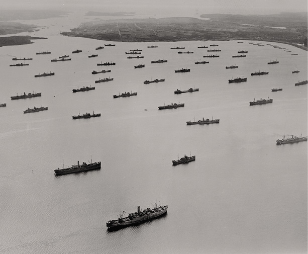
Convoy in Bedford Basin during the Second World War, 1942. This photo, looking towards the Narrows, Halifax peninsula, and the Atlantic Ocean, shows the fabulous size of the inner basin of Halifax Harbour.
Nova Scotia Archives
The Halifax Harbour, the largest and deepest natural harbour on the Atlantic coast, faces the open ocean and extends a total of thirty-two kilometres from Chebucto Head to the mouth of the Sackville River. Farther inland sits the Bedford Basin once a pre-glacial river, then an ancient freshwater lake, then, more preciously, a series of lakes after the ice age receded. As the ocean rose about five thousand years ago, the Narrows of the harbour flooded to create the saltwater basin of today. Three kinds of bedrock, called the Halifax Formation, characterize the harbours geological structure: slate, quartzite, and granite. Fertile drumlins moulded into hills by glaciers are present on both Georges Island and McNabs Island, as well as at Fort Needham on the Halifax peninsula. Today, the Sackville River flows into Bedford Basin where a deep channel drains through the basin and the Narrows close to the Dartmouth shore, before turning west of Georges and McNabs islands, flowing out by Herring Cove and Chebucto Head and into the Atlantic Ocean.
This grand harbourknown as Chebooktook or Chebucto, meaning big to the first inhabitants of the regionremains ice-free most winters. The nearby warm waters of the Gulf Stream heat the south-flowing Arctic currents to modify the Nova Scotia climate. Halifaxs harbour is also unique in that it narrows well inside the inner harbour and opens again, hourglass-like, into a huge basin surrounded by hills. This sheltered basin was large enough to hide entire fleets from enemy coastline patrols, which made Chebucto a great naval asset in the age of European expansion.
Early People
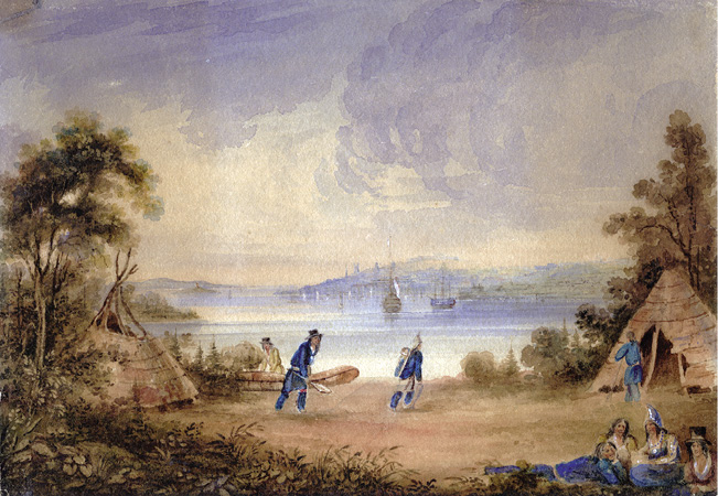
In ancient times, about 5000 BC, early ancestors of the Mikmaq began to summer at Halifax Harbour to hunt sea mammals and harvest seafood. Winters were spent inland and two historic waterways transported these first peoples back and forth. Old campsites at the mouth of the Sackville River point to an Indigenous portage route to the Annapolis Valley. And on the Dartmouth shore, at Tufts Cove and Dartmouth Cove, two small rivers lead back to the Shubenacadie lakes, where one could reach the Bay of Fundy in two days of good paddling.
Mikmaq encampment at Tufts Cove, looking towards Halifax c.1837. This oil on canvas painting is attributed to William Eager.
Nova Scotia Archives
In the 1800s, Indigenous communities existed on both sides of the harbourincluding at Armdale in Halifax and Red Bridge Pond and Millers Mountain in Dartmouthbut by the early 1900s most had vanished. A flourishing settlement comprising sixteen Mikmaw families under the leadership of Jerry Lonecloud remained at Turtle Grove near Tufts Cove on the Dartmouth shore.
The Mikmaq lived in birchbark wigwams in summer and wooden houses in the colder months, earning money making baskets, paddles, and oars. And their handcrafted hockey sticks were also well regarded throughout Nova Scotiaeven nearby Starr Manufacturing was producing a popular Mic-Mac brand stick.
While the 4.5-hectare site at Turtle Grove offered little agricultural potential, it did have a small school donated by Mikmaw landowner William Nevins. But white encroachment continued to negatively affect the community, perhaps because the land had easy access to the harbour. By 1917, the federal government had been working with Chief Lonecloud and the band to relocate to two possible sites: one nearby at Albro Lake and another at Shubenacadie.
Chapter 2
Founded in Conflict
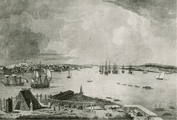
Town and harbour of Halifax from Georges Island looking north with Dartmouth shore on right, 1759. The British fleet is bound for the siege at Quebec during the Seven Years War. Drawing by Richard Short, purser aboard HMS Prince of Wales.
Nova Scotia Archives
Halifax was established in 1749 as a British military port to counter the French presence at Louisbourg and Quebec. English-speaking settlements south of Acadie were thriving, but France was contesting British military authority in North America and Acadie had become the latest battleground. Under Colonel Edward Cornwallis, an expedition of fifteen vessels and approximately 2,500 settlers left England, arriving at Chebucto Harbour on June 21, 1749. Upon landing they proceeded to erect a garrisoned settlement of about eight hectares on a side hill next to the water. Cornwalliss men fortified the hilltop overlooking the town by building log forts and palisades, the site of which would become known as Citadel Hill. The new town was named in honour of Lord Halifax, president of the Board of Trade and Plantations.
Many of these first settlers were inexperienced Londoners who were less than excited about enduring the harsh conditions of the new colony. Some escaped to more prosperous towns in the American colonies, but more settlersEuropean Protestants and hardy New Englandersarrived, establishing themselves north of Halifax as well as across the harbour at Dartmouth. These so-called foreign Protestants contributed greatly to the fortifications and public infrastructure of early Halifax. Within a decade, Halifax was at warthere were dozens of British ships-of-the-line docked in the harbour, and convoys sailed off to attack French positions at Louisbourg and Quebec.


