
Published by The History Press
Charleston, SC 29403
www.historypress.net
Copyright 2015 by James B. Stull
All rights reserved
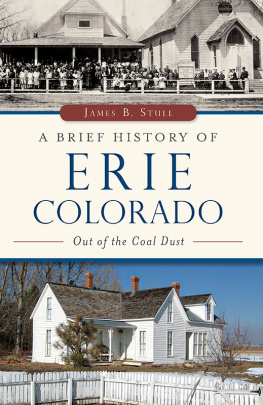
Front cover, top: The Erie Methodist Episcopal Church was built in 1888 by James L. Wilson. The Episcopal building was moved up Holbrook Street years later to serve as the social hall and, eventually, Eries community center. Erie Historical Society.
First published 2015
e-book edition 2015
ISBN 978.162585.580.0
Library of Congress Control Number: 2015937992
print edition ISBN 978.1.46711.811.8
Notice: The information in this book is true and complete to the best of our knowledge. It is offered without guarantee on the part of the author or The History Press. The author and The History Press disclaim all liability in connection with the use of this book.
All rights reserved. No part of this book may be reproduced or transmitted in any form whatsoever without prior written permission from the publisher except in the case of brief quotations embodied in critical articles and reviews.
To Dr. Sarah Allene Wise
CONTENTS
ACKNOWLEDGEMENTS
Thanks to the following people for their invaluable assistance with this project: Margaret Trostell Adams, Marianna Amicarella, Cammie Arneson, Patty Bray, Pat Bundy, Elle Cabbage, Reverend Jim Calhoun, Liz Campbell, Jess Castro, Tom Chrisman, Harold Conroe, Artie Crisp, Colleen Waneka Dame, Jim Dieke, Mary Dieke, Dennis Drumm, David Ferguson, Dean Ferguson, Patty Frobisher, John Garcia, Gayle Hepp, J.P. Holloway, Deb Jenkins, Karen Jones, Debbie Langerak, Sue Larson, Josh Lopez, Carolyn Allan McCarthy, Charlie McCarthy, Pam Mellskog, Steph Meyers, Josie Mosnik, Ruth Mosnik, Nancy Parker, Bill Pedrick, Jan Rice, Tommy Rizzi, Hallie Sawyer, James Sites, Katie Stitely, Penny Stull, David S. Sully Sullivan, Carol Taylor, Crystal Thornton, Chuck Waneka, Lois Regnier Waneka, Marlene Waneka, Gary Wetzbarger, Dianna Wilson, Ray Wilson, Alan Wise and Dr. Sarah Allene Wise.
You may have questions about this books content. Many topics can be researched further by looking at the references listed at the end of this book. Erie Town Hall has records that provide minute detail. The Images of America: Erie book contains 213 photographs. If you believe you have more accurate information, please feel free to contact the author at .
AN UNINHABITABLE LAND
The Town of Erie, Colorado, is located approximately twenty miles north of Denver and twelve miles east of Boulder. Before there was an Erie, the area was a barren high plain that had gone through many transformations over billions of years. Geologists have been able to identify the ages of rocks and fossils in Colorado from the Precambrian era (3.6 billion years ago) through the Cenozoic era (around 3 million years ago). They have chronicled some of the major evolutionary changes in the landmovement of continental plates, volcanic activity, the thrusting of mountains through the earths surface, subsidence, floods, icebergs, high winds and erosionall of which have contributed to Colorados landscape.
More than once, oceans covered the area from the Appalachian Mountains to the Continental Divide. As recently as 100 million to 70 million years ago, Colorado was covered by six hundred feet of ocean. At other times, the land was flat and tropical, with one hundred inches of rainfall per year. The area around Denver International Airport was lush and covered with palm trees. The tilted sandstone of the Front Range was sand on an ancient beach.
About 175 million years ago, the North American tectonic plate was shifting westerly. The Pacific plate was moving northeasterly. As the plates separated, they allowed softer, more viscous matter to push up from the earths mantle to form the Rocky Mountains. Between 85 and 70 million years ago, a subsequent shift pushed the Front Range and foothills up through the sea.
The plains are largely sedimentary layers of sandstone, shale and limestone, some resulting from alluvial deposits from rivers rushing out of the Rocky Mountains and others from the dried-up seabeds during the Cretaceous era. As these layers stacked on each other, they often trapped organisms in pockets. Trapped vegetation carbonized and became coal, while plankton and other ocean life became oil and natural gas.
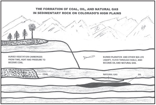
Nature provided the high plains with resources that played an important role in the establishment of the Town of Erie and in its continuing development. Authors drawing.
The quality or hardness of coal depended on how deep and long the vegetation was buried. In the Laramie geologic formation, or Northern Colorado Coal Field, lignite and subbituminous coal was more superficial. Extracting lignite coal from the ground would provide jobs for many during the 1800s and 1900s.
Oil is made up of plankton, algae and other sea life that lived in oceans and gathered energy from sunlight. When they died, they sank to the ocean floor and were eventually covered by sediment. The former sea life liquefied and seeped through the rock, settling as reservoirs. Some of the material is extracted as oil, some as natural gas. Colorados first oil well was drilled in the 1800s. Oil and natural gas have contributed significantly to Colorados economy from the mid-1900s to the present.
Rivers flowed out of the Rocky Mountains, but they only reached narrow strips of land throughout the Great Plains. After the oceans disappeared, the area was dry, sandy and bare of vegetation. Because of alluvial deposits from the rivers, the ground was full of gravel, with no topsoil for cultivation. It provided neither natural shelter nor trees for eventual visitors to build houses. The temperatures ranged from over one hundred degrees in the summer to negative thirty degrees or more in the winter. Torrential erosion, dust storms, hail, severe winter blizzards, tornadoes and grasshopper and locust infestations further contributed to making the Great Plains inhospitable.
Coal Creek flows near Old Town Erie. About twenty-nine miles long, it originates in Coal Creek Canyon on the eastern flank of Thorodin Mountain near Wondervu in the Front Range. It travels through Superior, Louisville and Lafayette. It enters Weld County at the southwest tip of Erie, runs east of Kattell Street and leaves Erie at Highway 52 to merge with Boulder Creek. The water then follows the course of the St. Vrain River, South Platte River, Platte River, Missouri River, Mississippi River and into the Gulf of Mexico.
Although wildlife and nomadic Native American tribes probably drank from it, Coal Creek was never the source of Eries drinking water. By 1858, it had become contaminated by various toxic chemicals used to expose minerals extracted by gold and silver miners in the Rocky Mountains. Still today, large volumes of cadmium, copper, manganese, lead and zinc are discharged from the mines and pollute many of Colorados rivers and streams, making them devoid of fish and other aquatic life and unfit for human consumption. However, creek water and mine wastewater were used for washing laundry and other purposes.
The first recorded flood swept through Erie in May 1876. Railroad tracks were washed out and had to be replaced. In 1890, another flood devastated parts of Erie near the creek. In 1920, a dike was built along Kattell Street. In 1921, Erie suffered the worst flood in its history when the dike broke. Some houses floated off their foundations. Bridges and railroad tracks were washed away. Reportedly, water was as high as countertops in the stores on Briggs Street. After cleanup, a wider channel was dug. In 1930, another dike was built along Kattell Street, but it gave way during subsequent flooding. In 1969, Coal Creek flooded again. Schools closed so students could help sandbag the creek. Bridges washed out and roads were closed. In 1972, another flood damaged a bridge north of town on County Line Road and the Coal Creek Bridge east of town. A new dike was constructed. In 2013, Erie suffered another devastating flood that also impacted many nearby towns and counties.
Next page
