2020 The University of North Carolina Press
All rights reserved
Set in Arno Pro by Westchester Publishing Services
Manufactured in the United States of America
The University of North Carolina Press has been a member of the Green Press Initiative since 2003.
Library of Congress Cataloging-in-Publication Data
Names: Erbig, Jeffrey Alan, Jr., author.
Title: Where caciques and mapmakers met : border making in eighteenth-century South America / Jeffrey Alan Erbig Jr.
Other titles: David J. Weber series in the new borderlands history.
Description: Chapel Hill : The University of North Carolina Press, 2020. | Series: The David J. Weber series in the new borderlands history | Includes bibliographical references and index.
Identifiers: LCCN 2019037841 | ISBN 9781469655031 (cloth) | ISBN 9781469655048 (paperback) | ISBN 9781469655055 (ebook)
Subjects: LCSH: CartographyHistory18th centuryPolitical aspectsSouth America. | Charrua IndiansLand tenure. | Genoa IndiansLand tenure. | Charrua IndiansGovernment relations. | Genoa IndiansGovernment relations. | South AmericaBoundariesHistory. | South AmericaColonizationHistory. | South AmericaEthnic relationsHistory. | SpainForeign relationsPortugalHistory. | PortugalForeign relationsSpainHistory.
Classification: LCC GA641 .E73 2020 | DDC 320.1/2dc23
LC record available at https://lccn.loc.gov/2019037841
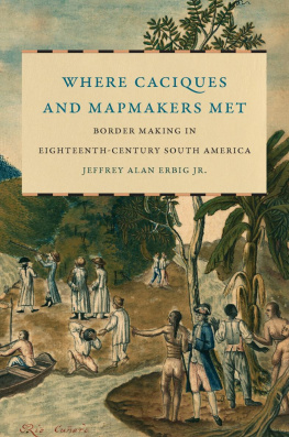
Cover illustration: Francisco Requena y Herrera, Cascadas del rio Cuar. Pequeo bote en que los dos comisarios fueron reconocer estas cascadas. B. Comisario espaol informandose de los ynfieles por medio del Negro ynterprete. Courtesy of the Oliveira Lima Library at the Catholic University of America.
Figures, Maps, and Tables
FIGURES
Jos Cardiel, Mapa de la Governacion del Paraguay y de la de Buenos Ayres, 1752
Lus Teixeira, Mapa das Capitanias hereditrias, c. 1574
Willem Blaeu, Americae nova tabula, 1665
Alonso de Santa Cruz, Islario general de todas las islas del mundo, [1500s]
Nicolas Sanson, Le Bresil, 1656
Rodrigo Annes de S Almeida e Menezes, Demonstracin Convincente de la Extensin del Territorio, [1725]
Herman Moll, The Great Province of Rio de la Plata, 1701
Guillaume de LIsle, Carte du Paraguay, du Chili, du Detroit de Magellan, etc., 1703
Jean Baptiste Bourguignon DAnville, Carte de LAmrique Meridionale, 1737
Jean Baptiste Bourguignon DAnville, Carte de LAmerique Meridionale, 1748
Carte manuscrite de lembouchure de Rio da Prata, 1740
Mapa dos Confins do Brazil com as terras da Coroa de Espanha na Amrica Meridional, 1749
Juan de la Cruz Cano de Olmedilla, Mapa Geogrfico de Amrica Meridional, 1775
Levinus Hulsius, Nova et exacta delineatio Americae, 1602
Giovanni Petroschi, Paraquariae provinciae, 1732
Miguel Angelo de Blasco, Mapa Que Contiene las marchas, 1756
Mapa Geographico del Terreno que demarcaron las Primeras Partidas, 1759
Miguel Antonio Ciera, Mappa geographicum, 1758
Josef Varela y Ulloa, Plano del Rio Vruguay, 1784
Jos de Saldanha, Mapa Corogrphico da Capitania de S. Pedro, 1801
Mapa Esferico de las Provincias Septentrionales del Rio de la Plata, 1796
Agustn Ibez y Bojons, Plano que slo manifiesta lo indispensable, 1804
MAPS
Approximate locations of the Madrid and San Ildefonso lines
Settlements and tolderas of the Ro de la Plata, 16751750
Caciques range of movement before 1750
Reported toldera locations by ethnonym, 16751750
Approximate itineraries of the Madrid boundary commissions and the Guaran War
Approximate itineraries of the San Ildefonso boundary commissions
New borders and settlements, 17501806
Reported toldera locations, 17501806
Reported cacique locations, 17501806
New ranches from the Guaran missions
Purported ethnic geographies
Purported migrations (Minuanes)
Purported migrations (Charras)
TABLES
Reported trade between tolderas and French ships
Reducciones and attempted reducciones in the Ro de la Plata, 16231750
Treaties guiding territorial possession in the Ro de la Plata up to 1750
Officers of the southern commissions during and after the demarcations
Spanish and mission raids
Toldera raids
Acknowledgments
This book is about geographies of knowledge production, and my own geography of research and writing is no exception. For more than a decade now, I have drawn on the expertise, support, and overall goodness of countless people in each of the seven countries in which I have researched and worked. The final product has only come to fruition because of the generosity of colleagues, friends, and family, each of whom has enriched my life along the way.
It has been a privilege to be supported by a cadre of wonderful mentors, who have inspired me intellectually and opened countless doors. Kathryn Burnss enthusiastic support for this project in all its twists and turns, and her patient reading and rereading of its chapters, has made her its principal interlocutor. Her wisdom regarding archives and the power inherent in knowledge production undergirds this books conceptual frame. Bernardo Michael first opened my eyes to connections between colonialism, space, and mapping and set me on the intellectual journey that would culminate in this book. John Chasteen has been a model for how to write and first introduced me to histories of the Ro de la Plata, while Cynthia Radding has been a tireless champion who taught me to think globally and comparatively. Fabrcio Prado has become the center of an international network of scholars studying the Ro de la Plata, and I have been one of the principal beneficiaries of his generosity and friendship. Judy Bieber was my closest conversant and supporter at the University of New Mexico, reading this work cover to cover on multiple occasions. From the time that I arrived at the University of California, Santa Cruz, Gabriela Arredondo has been a persistent advocate, and her teaching me to talk across disciplines as a historian inside-out has greatly benefited the writing of this text.

