• Complain

Reid Ewing - Best Practices in Metropolitan Transportation Planning

Here you can read online Reid Ewing - Best Practices in Metropolitan Transportation Planning full text of the book (entire story) in english for free. Download pdf and epub, get meaning, cover and reviews about this ebook. year: 2018, publisher: Routledge, genre: Politics. Description of the work, (preface) as well as reviews are available. Best literature library LitArk.com created for fans of good reading and offers a wide selection of genres:

Romance novel Science fiction Adventure Detective Science History Home and family Prose Art Politics Computer Non-fiction Religion Business Children Humor

Choose a favorite category and find really read worthwhile books. Enjoy immersion in the world of imagination, feel the emotions of the characters or learn something new for yourself, make an fascinating discovery.

Reid Ewing Best Practices in Metropolitan Transportation Planning
  • Book:
    Best Practices in Metropolitan Transportation Planning
  • Author:
  • Publisher:
    Routledge
  • Genre:
  • Year:
    2018
  • Rating:
    3 / 5
  • Favourites:
    Add to favourites
  • Your mark:
    • 60
    • 1
    • 2
    • 3
    • 4
    • 5

Best Practices in Metropolitan Transportation Planning: summary, description and annotation

We offer to read an annotation, description, summary or preface (depends on what the author of the book "Best Practices in Metropolitan Transportation Planning" wrote himself). If you haven't found the necessary information about the book — write in the comments, we will try to find it.

Planning at a metropolitan scale is important for effective management of urban growth, transportation systems, air quality, and watershed and green-spaces. It is fundamental to efforts to promote social justice and equity. Best Practices in Metropolitan Transportation Planning shows how the most innovative metropolitan planning organizations (MPOs) in the United States are addressing these issues using their mandates to improve transportation networks while pursuing emerging sustainability goals at the same time.As both a policy analysis and a practical how-to guide, this book presents cutting-edge original research on the role accessibility plays - and should play - in transportation planning, tracks how existing plans have sought to balance competing priorities using scenario planning and other strategies, assesses the results of various efforts to reduce automobile dependence in cities, and explains how to make planning documents more powerful and effective.In highlighting the most innovative practices implemented by MPOs, regional planning councils, city and county planning departments and state departments of transportation, this book aims to influence other planning organizations, as well as influence federal and state policy discussions and legislation.

Reid Ewing: author's other books


Who wrote Best Practices in Metropolitan Transportation Planning? Find out the surname, the name of the author of the book and a list of all author's works by series.

Best Practices in Metropolitan Transportation Planning — read online for free the complete book (whole text) full work

Below is the text of the book, divided by pages. System saving the place of the last page read, allows you to conveniently read the book "Best Practices in Metropolitan Transportation Planning" online for free, without having to search again every time where you left off. Put a bookmark, and you can go to the page where you finished reading at any time.

Light

Font size:

Reset

Interval:

Bookmark:

Make
1
Introduction and context

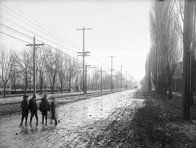
Salt Lake City, the central municipality in the Salt Lake City region, was founded in 1847. The City of Sandy, Utah, 13 miles away at the southern end of the Salt Lake valley, was settled beginning in the 1860s. At the time of the latters creation, the two jurisdictions were separated by orchards, open fields, and a lot of scrub. A single road State Street connected the two bergs (). But travel between the two was limited. Some commerce traveled up and down the road ore from nearby mines and produce from the communitys farms, mainly and people made occasional trips for church or social purposes. But basically, the two communities were self-contained. Salt Lakers tended to stay in Salt Lake and Sandyites stayed in Sandy.

Then, things changed. First came the railroad, with the Utah Southern connecting the two cities in 1871 (Tullidge, 1886). The interurban streetcar followed in 1907 and carried a rising number of workers from Sandy to jobs downtown and shoppers in search of a greater variety of goods (Bradley, 1993, p. 106). The automobile arrived in the Salt Lake valley in 1900 and started making a real presence in 1917 when vehicle registrations hit 21,576, nearly double the number from the previous year. By the onset of the Great Depression in 1930, the numbers reached more than 96,000 (FHWA, 1995).

After the Depression and World War II, interaction economic and otherwise between Salt Lake and Sandy increased dramatically. This, naturally, increased market attention on the lands between the two cities, with many of the farms and open lands being converted into commercial and residential developments. Annexations led to a 36 percent increase in Sandys jurisdictional territory during the 1950s, and in 1969 the city doubled in size during a single year. The Interstate Highway System came to the region during this same period. Constructed during the late 1960s/early 1970s, Interstate 80 tied the valley together east and west, whereas I-15 connected it north to south. Other links I-84 through Ogden and the I-215 circumferential beltway filled out the regions interstate pallet.

With all of these connections between the two cities, people began to travel back and forth much more frequently. Daily commuting to work between Sandy and Salt Lake had become the rule, not the exception.And people traveled between the two cities for other purposes, as well shopping, entertainment, education, recreation. By 1978, 65 percent of Sandyites reported that whereas they bought food locally, they traveled to other towns for other shopping (Bradley, 1993). Eventually, the rapid dispersion of employment to suburban places during the 1980s and 1990s led toward a partial balancing out in directional commute patterns, with people traveling to jobs in suburban towns like Sandy as much as they were traveling to Salt Lake City.

State Street Salt Lake City ca 1907 Used by permission Utah State - photo 1

State Street, Salt Lake City, ca. 1907.

Used by permission, Utah State Historical Society.

At some point during this history, the boundaries of each of the two cities and all of the other jurisdictions between became much less important to peoples daily lives. Whereas in earlier times, people might go for days or weeks without crossing their home citys boundaries, now they were crossing those boundaries daily, frequently several times a day. In the last year of the 20th century, intra-urban passenger rail began returning to the region after a half-century hiatus. By 2013, approximately 150 miles of light rail, heavy rail, and streetcar service helped tie together a vast interconnected and integrated landscape of 1,600 square miles and 1.8 million souls.
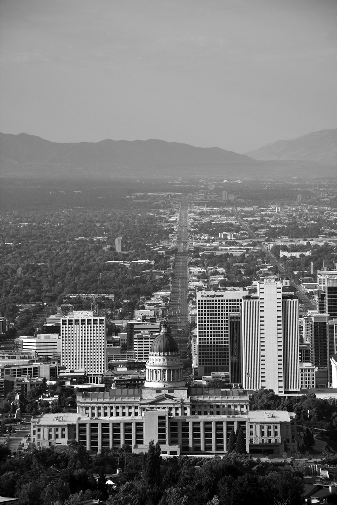
Figure 12 State Street Salt Lake City 2017 Photo Keith Bartholomew The - photo 2

Figure 1.2 State Street, Salt Lake City, 2017.

Photo: Keith Bartholomew.

The history of this one region mirrors the history of urban places all across America, and indeed across the globe. In the span of approximately one and a half centuries, our urban places have shifted from very localized nodes of semi-independent communities to expansive territories of interdependent conglomerations that function as webs of social and economic interaction. As Nelson and Lang note, Cities are defined by their spatially integrated functions, not by their political boundaries. The suburbs and even exurbs of a city are elements of the city writ large (2011, p. 1). In the shifts from mono-centric urban forms to poly-centric regions to edgeless cities, noted by Lang (2003), urban areas have become increasingly characterized by multidimensional overlapping networks of social, cultural, and economic ties that knit together people and institutions in ways that make only passing acknowledgment of municipal jurisdictional boundaries. Urban regions are the new uber-networks.

Economically, metro regions are, overwhelmingly, the source of Americas wealth. Katz and Bradley (2013) report that the nations 100 largest metro areas generate 75 percent of U.S. GDP. This prosperity comes not from an aggregation of a multitude of municipally based individual economies, but from regions operating as integrated systems. Indeed, metro regions appear to be eclipsing other geographic units including states and nation-states in economic importance. Referencing Kenichi Ohmaes The End of the Nation State , Dan Kemmis notes that more organic entities such as continents, city-regions, and coherent subcontinental regions are rapidly emerging as considerably more relevant economic entities than states, provinces, and nations (2001, p. 73). This is leading to what some refer to as an inversion of the traditional top-down federal-state-local hierarchy to a new power structure that places metro areas at the top.

The importance of the regional unit is demonstrated even more dramatically through ecological imperatives. Nothing in nature respects the political boundaries created by humans. Wildlife, air and the things that pollute it, vegetation, and the movement of water all operate according to forces that are independent of jurisdiction and government (though governments frequently take massive actions to influence these forces). In fact, it was the inadequacy of state boundaries to address the trans-boundary nature of watersheds that was a primary motivation for convening the U.S. Constitutional Convention in 1787.

Regions hang together through social institutions as well. As Calthorpe and Fulton (2001) note, cultural organizations, such as opera and ballet companies, sports facilities, religious temples and cathedrals, universities, and hospitals all operate through and for region-level populations, not just those of the municipality in which they are located. And increasingly, these institutions are not only located in central cities. In the Salt Lake area, the arena for the regions NBA franchise is in Salt Lake City, but the Major League Soccer team is in Sandy, and the hockey team is in West Valley City. Together, institutions create webs of interactions that further cement the idea of a region-scale sense of place. We might reference our individual neighborhoods or suburban towns when speaking to someone else from the same region. But when we travel nationally or internationally, we tell people that we live in San Francisco, or Seattle, or Chicago, or Salt Lake City, meaning not that we necessarily live within those municipalities, but that we come from those metro regions. In other words, we conceptualize home as a regional thing. As David Rusk has observed, the real city is the total metropolitan area city and suburb (1993, p. 5) the two are inseparable in cultural as well as functional terms.

Next page
Light

Font size:

Reset

Interval:

Bookmark:

Make

Similar books «Best Practices in Metropolitan Transportation Planning»

Look at similar books to Best Practices in Metropolitan Transportation Planning. We have selected literature similar in name and meaning in the hope of providing readers with more options to find new, interesting, not yet read works.


Reviews about «Best Practices in Metropolitan Transportation Planning»

Discussion, reviews of the book Best Practices in Metropolitan Transportation Planning and just readers' own opinions. Leave your comments, write what you think about the work, its meaning or the main characters. Specify what exactly you liked and what you didn't like, and why you think so.