Smart - Maps that made history the influential, the eccentric, and the sublime
Here you can read online Smart - Maps that made history the influential, the eccentric, and the sublime full text of the book (entire story) in english for free. Download pdf and epub, get meaning, cover and reviews about this ebook. City: Toronto, year: 2009;2004, publisher: Dundurn, genre: Religion. Description of the work, (preface) as well as reviews are available. Best literature library LitArk.com created for fans of good reading and offers a wide selection of genres:
Romance novel
Science fiction
Adventure
Detective
Science
History
Home and family
Prose
Art
Politics
Computer
Non-fiction
Religion
Business
Children
Humor
Choose a favorite category and find really read worthwhile books. Enjoy immersion in the world of imagination, feel the emotions of the characters or learn something new for yourself, make an fascinating discovery.

Maps that made history the influential, the eccentric, and the sublime: summary, description and annotation
We offer to read an annotation, description, summary or preface (depends on what the author of the book "Maps that made history the influential, the eccentric, and the sublime" wrote himself). If you haven't found the necessary information about the book — write in the comments, we will try to find it.
Few people can resist the appeal of old maps and plans. Even in these days of disposable mapping - from satellite navigation to customized road directions at the click of a mouse - the historical map continues to present a unique perspective on our changing world. Here we explore 25 glorious examples. The emphasis is on the story behind the map: what it reveals about its creator and users, from the first explorers to the railway builders. This thought-provoking collection features maps that chart societies as well as land, sea, and skies; maps that have influenced and inspired; and perhaps most revealing of all, maps that misrepresent.
Smart: author's other books
Who wrote Maps that made history the influential, the eccentric, and the sublime? Find out the surname, the name of the author of the book and a list of all author's works by series.

Maps that made history the influential, the eccentric, and the sublime — read online for free the complete book (whole text) full work
Below is the text of the book, divided by pages. System saving the place of the last page read, allows you to conveniently read the book "Maps that made history the influential, the eccentric, and the sublime" online for free, without having to search again every time where you left off. Put a bookmark, and you can go to the page where you finished reading at any time.
Font size:
Interval:
Bookmark:
MADE HISTORY
![]()
MADE HISTORY
and the sublime
![]()
To my family: Jenny, Joseph, Holly and Harry
Lez Smart 2004
This edition of Maps That Made History is published by arrangement with
The National Archives, UK.
The right of Lez Smart to be identified as the Author of this Work has been asserted by him in accordance with the Copyright, Designs and Patents Act 1988.
All rights reserved. No part of this publication may be reproduced, stored in a retrieval system, or transmitted in any form or by any means, electronic, mechanical, photocopying, recording, or otherwise (except for brief passages for purposes of review) without the prior permission of Dundurn Press. Permission to photocopy should be requested from Access Copyright.
Library and Archives Canada Cataloguing in Publication
Smart, Lez
Maps that made history : the influential, the eccentric and the sublime / Lez Smart.
ISBN 1-55002-562-7
1. Cartography History. 2. Maps Facsimiles. I. Title.
GA201.S62 2005 | 912'.09 | C2004-905783-9 |
1 2 3 4 5 08 07 06 05 04
Jacket illustration: a chart of the British Isles from John Sellers Atlas Maritimus, first published in c. 1678. John Seller (c. 1630-1697) was the first Englishman, in England, to compete with the Dutch as a producer of world marine atlases. Although as a nonconformist he was found guilty of conspiring to kill King Charles II, he was reprieved, and became Royal Hydrographer in 1671. He ran a nautical chart business from a shop near the Tower of London, and was also an instrument and globe maker. He published one of the first series of playing cards featuring world maps.
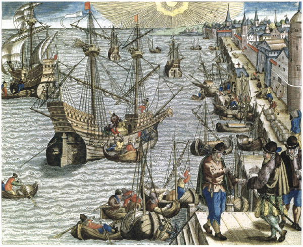
Frontispiece: Departure from Lisbon, by Theodore de Bry (see ).
).
).
Editorial, design and production by The Book Group, Somerset
Printed in Slovenia by MKT PRINT
Dundurn Press
8 Market Street, Suite 200
Toronto, Ontario, Canada
M5E 1M6
Dundurn Press
2250 Military Road
Tonawanda NY
U.S.A. 14150
www.dundurn.com
Im not absolutely sure when I first became aware that I found maps fascinating. I think it was probably on family holidays when I was a child. Each year our family made its way across Leicestershire and Lincolnshire in a small car to the east coast holiday town of Mablethorpe. As the eldest child I was charged with the responsibility of reading the map and advising my Dad as to the correct route. This invariably took the form of identifying the next place we should come to, calling it out as we reached it and then identifying the next one. Most of these places were tiny villages with wonderful names such as Frisby on the Wreake, Waltham on the Wolds, Tattershall and everyones favourite, Maltby le Marsh the reason for the popularity of the latter arising from the fact that it meant we were almost there! I remember wondering who had given these places their names? Why did Maltby have a French name? Why had they made the streets so wiggly (very much a Leicester word)? I didnt just want to use the map, I wanted to know more about it, the places on it and the people who had made it the way it was. Although I didnt realize it at the time the asking of these questions was the beginning of a lifelong fascination. As my bookshelves and the walls of my house bear witness, the writing of this book is just one manifestation of this interest.
In the process of writing it I have examined maps in the hushed Map Rooms of the National Archives and the British Library maps and locations far removed from the crumpled road atlas of the East Midlands flattened out on the dashboard of a Ford Popular. And yet the questions asked of these often unique and priceless maps was not that dissimilar from my questions as a child. Who made this map? Why did they make it? When did they make it? Why did they decide to give that name to that place? What does that line/symbol mean? How did they know it looked like that?
These, and further questions, are the ones asked in the following pages. As will be seen, sometimes the answers can be ascertained, sometimes they have to be surmised and sometimes we just dont know. And thats why they continue to fascinate.
Lez Smart
Without the persistence and tenacity of Sheila Knight, Deputy Publishing Manager at the National Archives, this book would not have been written. Id like to thank her for seeing the potential behind the ideas we discussed at out first meeting and being supportive all the way through.
Thanks are due to Paul Johnson and especially Hugh Alexander who form the National Archives Image Library team. Their suggestions and advice were invaluable. Thanks also to Jenny Speller whose painstaking work in tracking down permissions to use formed one of those vital but unsung tasks. Thanks to all at The Book Group for their editorial and design contributions.
However, my major thanks must go to my wife Jenny. Her unflagging support for this project and her willingness to listen to my enthusiastic account of yet another obscure detail from an equally obscure map was beyond the call of duty. Thanks Jen.
Finally, a word of thanks to Harvey for taking up his position under the desk each day with never a complaint.
).
We need maps. We have always needed maps. We always will. The marks found in the caves of our ancestors have been interpreted as maps and every society that has existed throughout history, in every corner of the globe, has created its own maps. They form one of the ways by which each society has sought to represent, record and communicate its world.
While the scale, size and detail may vary all maps show the relationship between one place and another. They include the details that are, or were, deemed significant and omit the ones that are or were not. No map has ever, nor can ever show everything.
When faced with a map most people will immediately seek to identify a reference point from which to start: Theres our street; I went there for my holiday; Your grandmother was born there or even One day Im going to go there. This is perfectly natural because it is essential to get ones bearings and establish a point from which to make sense of the information on the map.
This ability to read a map is part of a skill known as visual literacy and involves being able to make sense of symbols, images and colours either alongside or in the absence of words. This literacy was present in the earliest humans, and has continued through the ancient civilizations into modern times. It is no less important a skill to possess than reading and writing. As the evidence from the earliest cave markings to the maps drawn by children showing their way to school illustrate, the ability to make and use maps may be a natural skill rather than a learned one.
Font size:
Interval:
Bookmark:
Similar books «Maps that made history the influential, the eccentric, and the sublime»
Look at similar books to Maps that made history the influential, the eccentric, and the sublime. We have selected literature similar in name and meaning in the hope of providing readers with more options to find new, interesting, not yet read works.
Discussion, reviews of the book Maps that made history the influential, the eccentric, and the sublime and just readers' own opinions. Leave your comments, write what you think about the work, its meaning or the main characters. Specify what exactly you liked and what you didn't like, and why you think so.