Aharoni Yohanan - The Carta Bible Atlas
Here you can read online Aharoni Yohanan - The Carta Bible Atlas full text of the book (entire story) in english for free. Download pdf and epub, get meaning, cover and reviews about this ebook. year: 2011, publisher: Carta Jerusalem, genre: Religion. Description of the work, (preface) as well as reviews are available. Best literature library LitArk.com created for fans of good reading and offers a wide selection of genres:
Romance novel
Science fiction
Adventure
Detective
Science
History
Home and family
Prose
Art
Politics
Computer
Non-fiction
Religion
Business
Children
Humor
Choose a favorite category and find really read worthwhile books. Enjoy immersion in the world of imagination, feel the emotions of the characters or learn something new for yourself, make an fascinating discovery.

- Book:The Carta Bible Atlas
- Author:
- Publisher:Carta Jerusalem
- Genre:
- Year:2011
- Rating:5 / 5
- Favourites:Add to favourites
- Your mark:
The Carta Bible Atlas: summary, description and annotation
We offer to read an annotation, description, summary or preface (depends on what the author of the book "The Carta Bible Atlas" wrote himself). If you haven't found the necessary information about the book — write in the comments, we will try to find it.
Aharoni Yohanan: author's other books
Who wrote The Carta Bible Atlas? Find out the surname, the name of the author of the book and a list of all author's works by series.


The Carta Bible Atlas — read online for free the complete book (whole text) full work
Below is the text of the book, divided by pages. System saving the place of the last page read, allows you to conveniently read the book "The Carta Bible Atlas" online for free, without having to search again every time where you left off. Put a bookmark, and you can go to the page where you finished reading at any time.
Font size:
Interval:
Bookmark:
Table of Contents
THE CARTA BIBLE ATLAS
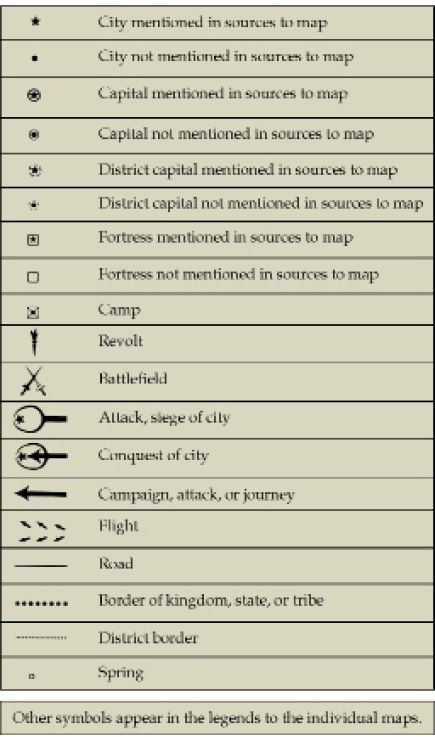
LIST OF SYMBOLS
LEGEND TO GEOGRAPHICAL NAMES
NOTE ON SOURCES
Geographical names and quotations from the Bible are from the Revised Standard Version. Those from the Apocrypha are from the American Bible Society edition. If the spellings in the Versions are not consistent, preference has been given to that spelling closest to the Hebrew form. Geographical names and quotations from external sources are based, in the main, on Ancient Near Eastern Texts Relating to the Old Testament , edited by J. Pritchard, Princeton University Press, and the Loeb edition of Josephus works, but certain modifications have been made. In the spelling of classical place-names, Latinized forms have generally been used; the A in ae, however, has been eliminated in most cases, except in such names as Caesar and Aegina, where accepted usage dictates otherwise. The variant spelling tel and tell represent the Hebrew and the Arabic, respectively.
A NOTE ON THE CHRONOLOGY
Ancient Near Eastern chronology is based on the coordination of historical events, especially the years of a kings reign with known astronomical phenomena the age of which can be calculated. The chronology of Egypt adopted here is that generally followed by scholars at the Oriental Institute of the University of Chicago. Obviously, the Old and Middle Kingdoms are subject to revision as new data come to light; the New Kingdom is fairly well established though there are still two options, a higher and a lower. That based on the 1504 accession date for Thutmose II has been incorporated here. The wealth of data from the Third Intermediate Period, which parallels the biblical monarchies of Israel and Judah, makes the chronology more accurate though there is apparently still room for modification. By the Saite period (664 b.c.) the dates are coordinated with those of Mesopotamia.
For the Hebrew kings, the chronology as worked out by E. R. Thiele is adopted throughout. It enjoys numerous links with firm Assyrian and Babylonian dates. The pre-monarchial period, including the Age of the Patriarchs and the Age of the Judges, has no certified contacts with ancient Near Eastern history; their relative chronologies can only be surmised on the basis of comparison with the general archaeological framework.
The chronology of the Hellenistic and Roman periods is fairly well established and presents no special problems. The dates of events mentioned in the New Testament have been fitted, as far as possible, within the general chronology
framework.
ON THE MAPS:
Names in parentheses are non-contemporary or modern; where appended to another name, however, they may be contemporary variants.
Names within frames are of places as yet unidentified, though their general location is known from the sources.
THE FOUR WINDS OF THE HEAVENS AND THEIR NAMES
The Lord said to Abram ... Lift up your eyes, and look from the place where you are, northward and southward and eastward and westward; for all the land which you see I will give to you and to your descendants for ever.
(Genesis 13:14-15)
To the north the winterbound, snow-covered mountains of the Lebanon; to the south the semiarid Negeb; to the east the wide desert; to the west the Great Sea these are the natural borders of Canaan/Israel. Within their confines was enacted the history of Israel from the days of the Patriarchs on. A look at the landscape, its roads and ancient settlements, and the countries surrounding it are a prerequisite for a proper understanding of this history.
We possess no ancient map depicting the Holy Land in the biblical period. If such did exist, we can assume that it would face eastward, for in ancient Hebrew the word forward also indicates east, behind and seaward mean west, right means south, and left means north. Benjamin (the son of the right hand) is the southernmost of the Rachelite tribes; the Dead Sea is also referred to in Hebrew as the forward (eastern) sea; the Great Sea, the Mediterranean of today, is also called the latter (western) sea.
One of the oldest maps extant is the Medeba map. This is a mosaic floor dating from the sixth century A.D. in a church at Medeba, to the east of the Dead Sea. This map was intended to show the Holy Land of the Bible and faces eastward. At the center appears the Dead Sea, on which sail two boats. It was prepared more than one thousand years after the Destruction of the First Temple, and thus is of limited value for the identification of ancient sites.
MAP-1: THE FOUR WINDS OF THE HEAVENS AND THEIR NAMES
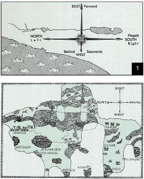
Section of the Medeba Map (Place names translated from the Greek)
THE WAY TO SHILOH
I will send them out that they may set out and go up and down the land, writing a description of it with a view to their inheritances...
(Joshua 18:4)
The Bible does not, as a rule, give many descriptions of settlements, their location and character these matters were taken for granted then. Only a few verses diverge from this rule, the outstanding case being the description of the site of Shiloh in the story of the abduction of wives for the Benjaminites: So they said, "Behold, there is the yearly feast of the Lord at Shiloh, which is north of Bethel, on the east of the highway that goes up from Bethel to Shechem, and south of Lebonah" (Judg. 21:19). Nothing could be more accurate. Why did the biblical writer give such detail to the location of a site as famous in ancient times as Shiloh? Probably because Shiloh had been destroyed by the Philistines, and early in the period of the Monarchy, when the story was written down, it lay in ruins.
Unlike Shiloh, most locations are merely described in vague terms in the Bible. Thus, in reconstructing the ancient map of the Holy Land in the various periods, we must lean heavily on four factors:
1. analysis of the history, character, and general topography of the individual site in the light of available sources;
2. identifications in later sources;
3. the preservation of the ancient name, with possible modifications during transfer from Hebrew to Aramaic and Arabic; and
4. archaeological examination of the site under consideration in the light of the above data.
MAP-2: THE WAY TO SHILOH

JUDG. 21:19
THE ANCIENT NEAR EAST PHYSICAL
From the wilderness and this Lebanon as far as the great river, the river Euphrates, all the land of the Hittites to the Great Sea toward the going down of the sun shall be your territory.
(Joshua 1:4)
Archaeological research has made great strides in our times, and many details of the map of the ancient Holy Land are now agreed upon.
The decisive geographical factor in the history of Canaan/Israel is its outermost position at the southwest end of the settled, fertile lands of the Near East. These lands stretch crescentlike from the Persian Gulf to the Sinai Peninsula: the so-called Fertile Crescent. On the west, this crescent touches the Mediterranean Sea. On the north and the east it is surrounded by high, nearly impassable mountains, the Amanus, Taurus, Ararat, and Zagros ranges. Within the hollow of the Fertile Crescent lies the extensive Syrian-Arabian Desert, extending on the west into the wilderness of Paran (the Sinai Peninsula). This latter separates the Holy Land from Egypt.
Font size:
Interval:
Bookmark:
Similar books «The Carta Bible Atlas»
Look at similar books to The Carta Bible Atlas. We have selected literature similar in name and meaning in the hope of providing readers with more options to find new, interesting, not yet read works.
Discussion, reviews of the book The Carta Bible Atlas and just readers' own opinions. Leave your comments, write what you think about the work, its meaning or the main characters. Specify what exactly you liked and what you didn't like, and why you think so.