1.1 Humble Beginnings
In 1852 Francis W. Guthrie, a graduate of University College London, posed the following question to his brother Frederick:
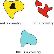
Imagine a geographic map on the earth (that is, on a sphere) consisting of countries onlyno oceans, lakes, rivers, or other bodies of water. The only rule is that a country must be a single contiguous massin one piece, and with no holessee Fig.). How many colors should the map-maker keep in stock in order to be sure he/she can color any map?
Figure 1.1
What is a country?
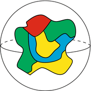
In fact, it was already known from experience that four colors suffice to color any map; the point was that no one had given a mathematical proof confirming the empirical observation.
Figure 1.2
A map coloring.
Frederick Guthrie was a student of the mathematician Augustus De Morgan (18061871), and he ultimately communicated the problem to his mentor. The problem was passed around among academic mathematicians for a number of years [in fact De Morgan communicated the problem to William Rowan Hamilton (18051865)]. The first allusion in print to the problem was by Arthur Cayley (18211895) in 1878.
These were all serious mathematicians, and it was rather surprising that such an elementary and accessible problem should prove so resistive to their best efforts. The problem became rather well known, and was dubbed The Four-Color Problem .
The eminent mathematician Felix Klein (18491925) in Gttingen heard of the problem and declared that the only reason the problem had never been solved is that no capable mathematician had ever worked on it. He , Felix Klein, would offer a class, the culmination of which would be a solution to the problem. He failed. Even so, Klein believed (and it was generally believed) that four colors would suffice to color any map. Certainly all the known examples pointed in that direction.
1.2 Kempe, Heawood, and the Chromatic Number
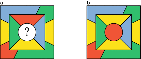
One reason the four-color problem is challenging is that one cannot simply piece together colorings of smaller maps to get a desired coloring of a bigger map. For instance, the map in Fig., then we will need to interchange some of the colors to avoid having a border with the same color on both sides. Similarly, if a new country is inserted somewhere in a four-colored map, then some of the existing colors may need to be changed to color the new map with only four colors.
Figure 1.3
A successful coloring.
Figure 1.4
Two four-colored maps needing recoloring before merging.
In 1879, Alfred Kempe (18451922) published what was believed to be a solution of the four-color problem. That is, he showed that any map on the earth (that is, the sphere) could be colored with four colors. Kempes proof turned out to be flawed, but it took 11years for anyone to discover the error.
Kempes argument involved first removing countries from the map in a carefully chosen order, then adding them back, recoloring the map as needed with each addition. The carefully chosen order was in fact designed to guarantee that each country that is added back borders no more than five countries. No recoloring is required if a reinserted country borders 1, 2, or 3 other countries, but it may be needed when the reinserted country borders 4 or 5 countries.
The first interesting case occurs when the reinserted country borders 4 existing countries and those countries have been colored using all four colors. The situation might be similar to that in Fig.b.
Figure 1.5
The easy case of adding back a country that borders all four colors ( a ) The initial coloring ( b ) After changing one red country to yellow, the new country can be colored red.
Kempes new idea was to extend this argument to more countries. For example, in Fig.a the new country is again surrounded by all four colors. None of the four surrounding colors can be changed individually, because each of those four countries also touches all three of the other colors.
Kempes procedure for coloring the new country relies on planning for many simultaneous color changes. Pick a pair of colors on opposite sides of the new country. We will pick red and yellow. Then, starting with the red country on top, form a larger set containing all the yellow countries it borders. Then include in the set all the red countries that those yellow countries border. Continue this process until no more countries get included. The set of countries just constructed is a Kempe chain . (Dont take the name chain too literallya Kempe chain is not necessarily a sequence, it may branch and/or contain contiguous clumps of countries.) Once the chain is formed, as in Fig.b, it is certainly harmless (i.e., introduces no countries sharing a border that are colored the same) to interchange the colors red and yellow in the Kempe chain.
There are now two cases:
(1)
The first possibility is that the Kempe chain does not include the country that is opposite the country that started the chainthat is the case in Fig.d.
Figure 1.6
Using a Kempe chain to add back a country that borders all four colors when the chain does not close up ( a ) The initial coloring ( b ) Form the Kempe chain ( c ) Change colors in the chain ( d ) Color the new country.
(2)
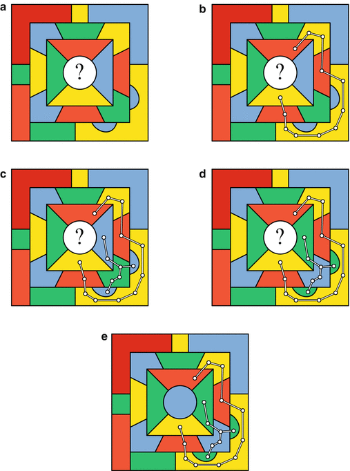
The second possibility is that the Kempe chain does include the country that is opposite the country that started the chain. This case is illustrated by the map in Fig.e.
Figure 1.7
Using a Kempe chain to add back a country that borders all four colors when the chain closes up ( a ) The initial coloring ( b ) Form the Kempe chain ( c ) Form a second chain ( d ) Change colors in the second chain ( e ) Color the new country.

