
DISCOVERY
DISCOVERY
THE STORY OF THE SECOND BYRD ANTARCTIC EXPEDITION
Published by Rowman & Littlefield
A wholly owned subsidiary of The Rowman & Littlefield Publishing Group, Inc.
4501 Forbes Boulevard, Suite 200, Lanham, Maryland 20706
www.rowman.com
Unit A, Whitacre Mews, 26-34 Stannary Street, London SE11 4AB
Distributed by NATIONAL BOOK NETWORK
Copyright 1935 by Richard E. Byrd
Cloth edition originally published by G. P. Putnam's Sons in 1935
First Rowman & Littlefield paperback edition 2015
All rights reserved. No part of this book may be reproduced in any form or by any electronic or mechanical means, including information storage and retrieval systems, without written permission from the publisher, except by a reviewer who may quote passages in a review.
British Library Cataloguing in Publication Information Available
Library of Congress Cataloging-in-Publication Data Available
Paperback: 978-1-4422-4166-4
E-book: 978-1-4422-4167-1
 The paper used in this publication meets the minimum requirements of American National Standard for Information SciencesPermanence of Paper for Printed Library Materials, ANSI/NISO Z39.48-1992.
Printed in the United States of America
TO
EDSEL FORD
ILLUSTRATIONS
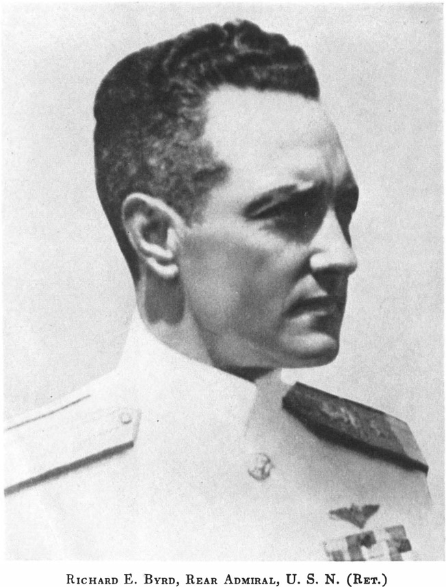
Richard E. Byrd, Rear Admiral, U. S. N. (Ret.)
S. S. Jacob Ruppert
S. S. Bear of Oakland
Easter Island
Mid-Pacific
Commodore Gjertsen Taking a Sight
Mal De Mer
The William Horlick on Her Cradle Just Before the First Flight
Sentinels of the Southern Seas
The William Horlick Ready to Take the Air
The Flight Crew Preparing to Board the Plane
The Pack Rolls to the Horizon
A Mosaic of Pack (from the Air)
Seals Sunning on an Ice Floe
The William Horlick Overboard
First View of the Barrier
A First Family of Antarctica
The Jacob Ruppert Approaches the Bay Ice
A Stately Promenade
Admiral Byrd Steps Ashore
Four Years of Ice Crystals in the Old Tunnel
Blazing a Trail through the Pressure
On the Main Highway to Little America
An Intermediate Cache
The Big Haul Goes On
A Dog Team and the Bear of Oakland
Tons of Supplies
The Corniche Road
Uncharted Seas OS
The Bear Returns
The Bridge of Sighs
The First Days of the Occupation
Frontier Settlement
Main Street, Little America
The Wreck of the Fokker, Blue Blade
Airport
The Citron Hits a Crevasse
Pete Demas
Captain Alan Innes-Taylor
The Advance Base Tractor Party
The Advance Base Caravan
Laying the Foundations for Advance Base
Admiral Byrd and Siple Examine the Instruments
Farewellfor the Winter Night
The Tractors Depart for Little America
Dog-Town
Some of the New BuildingsDog Heim and the Radio Shack
Building a Shelter for the Planes
Winter Night
Observing Meteors
Meeting of the Scientific Staff
William Haines, Senior Meteorologist
Dr. Bramhall and Cosmic Ray Machine
Grimminger Starting a Balloon Run
The Fireside Philosophers
Dr. Potaka Uses Painless Dentistry on Corey
George Noville, Executive Officer
Innes-Taylor and Moody Take to Surgery
The Pressure by Torchlight
Admiral Byrd at the Radio (Advance Base)
Demas, Poulter and Waite Start for Advance Base
Spring Comes to the Antarctic
The Sledgers Start Out
Planting a Flag on the Eastern Tractor Trip
Pressure Ice at the Mouth of Ver-Sur-Mer Inlet
The Seals Provide Entertainment for Two Skiers
Planning a Flight
The William Horlick Comes Out of Its Winter Cocoon
The Condor Plane William Horlick
The Condor in the Air
The Plane Visits the Tractors
Harold I. June, Chief Pilot
Snared
Heating the Motors
The Radio StaffBailey, Waite, Dyer, Hutcheson
The Raymond Fosdick Mountains Break Out of the Clouds
The Pilgrim Plane, Miss American Airways
Crevasse
The Marie Byrd Land Party in the Edsel Fords
The Geological Party Miles from the South Pole
The Organ Pipes of Thorne Glacier
Admiral Byrd Welcomes the Marie Byrd Land Party
Fossil Tree Found at Mt. Weaver
Jack the Giant Killer
The Bay of Whales Frozen
Little America From the Air
The Geological PartyRussell, Blackburn, and Paine
The Southern Tractor PartyHill, Demas, and Waite
A Seismic Sounding
Lindsey and Young Weigh a Baby Seal
Black, Ronne, and Morgan at the Top of Mt. Nilsen (Rockefellers)
The Bear Ties Up at Bolling Bight
The Cletrac Hauls the Floyd Bennetts Wings to the Ship
Admiral Byrd and Lieut. Commander Noville Lower the Flag
NOTES ON THE MAPS AND SURVEYS
By KENNETT L. RAWSON
THE two small scale maps appearing in the book were prepared during the summer of 1935 in the cartographic department of the National Geographic Society to show in a general way the geographic work of the Second Byrd Antarctic Expedition.
Before going into a detailed description of the maps, I want to take this opportunity to express the great debt which this expedition and the preceding one owe to Commander (C. C.) Harold E. Saunders, U. S. N., expedition chief cartographer. It is hard to conceive of any ones handling the survey material with greater skill or more devoted perseverance. His work, especially on the aerial photographs, represents a distinct advance in the technique of constructing maps from oblique photographs.
The South Pacific map (reproduced elsewhere in this book) constructed by Lieutenant (J. G.) R. A. J. English, U. S. N., shows the tracks of the two ships, the Jacob Ruppert and the Bear of Oakland and the flights from the Jacob Ruppert of the airplane William Horlick. Both the cruises of the ships and the flights have been described in detail elsewhere.
The map shows primarily that the geographic results of our work at sea were purely negative. No new land was discovered anywhere in the previously unknown area which was penetrated. But the results, while negative, were none the less significant. The southern known limits of the Pacific Ocean were moved considerably farther south in the vicinity of the flight tracks and along parts of the route of the Jacob Ruppert. The Bear of Oakland also drove a wedge into a section of the Ross Sea and Pacific Ocean which had previously been considered likely to contain an archipelago. No trace of such was detected and none probably will be, because of the great depth of water found there. Of even greater significance was the restriction of the possible area in which the continental coast line can lie. Coupled with the flights to the eastward of Little America, the work at sea has narrowed this down to a fairly small compass.
Lieutenant English in the Bear of Oakland made a careful survey of the Ross Ice Barrier during January 1935. It is interesting to note that the Barrier has advanced on an average of 12 nautical miles (13.8 statute) along the whole front between Ross Island and the Bay of Whales. The 1911 position is taken from Pennells charts and Debenham's
Next page






 The paper used in this publication meets the minimum requirements of American National Standard for Information SciencesPermanence of Paper for Printed Library Materials, ANSI/NISO Z39.48-1992.