Edwin C. Guillet - Pioneer Travel in Upper Canada
Here you can read online Edwin C. Guillet - Pioneer Travel in Upper Canada full text of the book (entire story) in english for free. Download pdf and epub, get meaning, cover and reviews about this ebook. year: 1963, publisher: University of Toronto Press, genre: Romance novel. Description of the work, (preface) as well as reviews are available. Best literature library LitArk.com created for fans of good reading and offers a wide selection of genres:
Romance novel
Science fiction
Adventure
Detective
Science
History
Home and family
Prose
Art
Politics
Computer
Non-fiction
Religion
Business
Children
Humor
Choose a favorite category and find really read worthwhile books. Enjoy immersion in the world of imagination, feel the emotions of the characters or learn something new for yourself, make an fascinating discovery.

- Book:Pioneer Travel in Upper Canada
- Author:
- Publisher:University of Toronto Press
- Genre:
- Year:1963
- Rating:3 / 5
- Favourites:Add to favourites
- Your mark:
Pioneer Travel in Upper Canada: summary, description and annotation
We offer to read an annotation, description, summary or preface (depends on what the author of the book "Pioneer Travel in Upper Canada" wrote himself). If you haven't found the necessary information about the book — write in the comments, we will try to find it.
Guillet draws on contemporary letters, diaries, newspapers, and periodicals, in order to describe vividly the conditions of travel at various periods.
Edwin C. Guillet: author's other books
Who wrote Pioneer Travel in Upper Canada? Find out the surname, the name of the author of the book and a list of all author's works by series.


Pioneer Travel in Upper Canada — read online for free the complete book (whole text) full work
Below is the text of the book, divided by pages. System saving the place of the last page read, allows you to conveniently read the book "Pioneer Travel in Upper Canada" online for free, without having to search again every time where you left off. Put a bookmark, and you can go to the page where you finished reading at any time.
Font size:
Interval:
Bookmark:
PIONEER TRAVEL IN UPPER CANADA
in Upper Canada

By
EDWIN C. GUILLET

C OPYRIGHT , C ANADA , 1933
BY
E DWIN C. G ULLET
R EPRINTED 1963
BY U NIVERSITY OF T ORONTO P RESS
C ANADIAN U NIVERSITY P APERBOOKS E DITION , 1966
This volume contains Section IV
of Early Life in Upper Canada, Pioneer Travel and Transportation
P RINTED IN THE U.S.A. BY O FFSET L ITHOGRAPHY
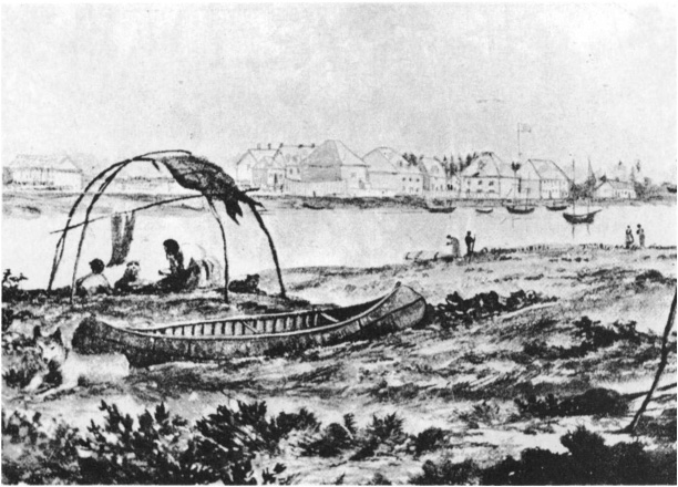
The next day was calm, and we arrived at the entrance of the navigation which leads to Lake aux Claies. We presently passed two short carrying-places, at each of which were several lodges of Indians containing only women and children, the men being gone to the council at Niagara.... On the 18th of June we crossed Lake aux Claies, which appeared to be upward of twenty miles in length. At its further end we came to the carrying-place of Toronto. Here the Indians obliged me to carry a burden of more than a hundred pounds weight. The day was very hot, and the woods and marshes abounded with mosquitoes; but the Indians walked at a quick pace, and I could by no means see myself left behind. The whole country was a thick forest, through which our only road was a foot-path, or such as, in America, is exclusively termed an Indian path. Next morning at ten oclock we reached the shore of Lake Ontario. Here we were employed two days in making canoes out of the bark of the elm tree, in which we were to transport ourselves to Niagara.... On the 21st we embarked at Toronto, and encamped, in the evening, four miles short of Fort Niagara, which the Indians would not approach till morning.
A LEXANDER H ENRY (1764)
B EFORE the arrival of Europeans in America the native Indians had well-defined routes of travel which they used in hunting trips and on the war-path. In these long journeys they followed the waterways wherever it was possible to do so, and used portage paths to avoid rapids. Well-travelled trails, often worn from six inches to a foot into the ground, were followed through the woods from one body of water to another; and these paths were observed and used by the earliest French explorers and traders. The Indians found canoe travel on the Great Lakes impracticable except close to shore or among islands. They also avoided dangerous rapids, such as those on the St. Lawrence, whenever it was possible to accomplish their purpose by an easier route. The routes by which the Indians crossed Lake Ontario at the eastern end are thus described by William Canniff:
There is evidence that the Mohawks, upon the southern shore of Lake Ontario, were accustomed to pass across the
There were several routes by which the Indians travelled northward and westward. By the long chain of lakes and rivers now known as the Trent system, and early called the Toronto Lakes, they penetrated to Lake Simcoe, and on by Lake Couchiching and the Severn to Georgian Bay and the upper lakes. This was the route over which in 1615 the Hurons led Champlain from Georgian Bay to Lake Ontario, and it was long considered the most direct way; over two centuries later the same belief prompted the construction of the Trent Valley Canal.
Other routes which were followed northward by the Indians as approaches to the headwaters of the Trent system were the rivers emptying into Lake Ontario, such as the Cataraqui (Rideau), the Napanee, the Moira, the Ganerask, Duffins Creek, the Rouge, Don, Humber and Credit. In addition to the Jesuit mission stations earlier inaugurated in Huronia there were Sulpician missions at or near the mouths of some of these rivers. One was established in 1668 in the Cayuga Indian village of Kent on the south side of Prince Edward County, either on West Lake or Wellers Bay; another, Ganneious, was located not far from the mouth of the Napanee River; a third, Ganerask, on the site of Port Hope; a fourth, Gandalskiagon or Gandaseteiagon, at Frenchmans Bay, the port of Whitby; and a fifth at Teieiagon, between the Humber and Credit. A mission was also located on the St. Lawrence opposite Prescott, at the mouth of the Oswegatchie River; this post, situated on the present site of Ogdensburg, was commenced in 1749.
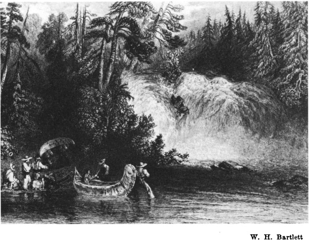
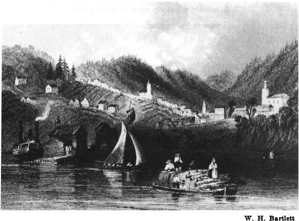
L ES C HATS F ALLS , U PPER O TTAWA R IVER , 1840
A romantic beauty-spot in early times
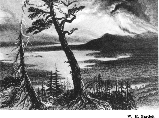
L AC DES A LLUMETTES IN 1840
Where Champlains Voyage of 1613 ended
F ORT W ILLIAM IN 1856
P ORT H OPE , 1840
The site of the Ganerask Mission of the French period; the Indian Village Pemiscutiank or Cochingomink (the commencement of the portage); in the days of the fur trade (1778-1819) called Smiths Creek; and for a short time known as Toronto post office
The importance of these locations led to the establishment of trading-posts at most of them before or during the days of early settlement. Three of these antedated settlement, the post at Pemiscutiank or Cochingomink (the commencement of the portage), later called Smiths Creek (Port Hope), established about 1778; Fort Rouill, near the mouth of the Humber, erected by the French in 1750; and the Oswegatchie trading-post, which was by 1753 important in the French trade with the Onondaga, Oneida and Cayuga Indians.
The Humber trail was by far the most important of the routes to the Trent system and Lake Simcoe. As early as 1615 the Huron Indians led Etienne Brl across this portage from Lake Simcoe to Lake Ontario, and probably proceeded southwards as far as the Niagara district, for from the mouth of the Humber a Mississaga trail was well beaten where the present Lake Shore Road runs, and the path continued to the Falls of Niagara and beyond. The entire Niagara region was intersected by well-known trails from Indian days down through the French and early British periods. In 1640 Brbeuf and Chaumonot travelled from a Huron mission in the present Township of Medonte, near Penetanguishene, to the Indian village Onguiara, near Queenston, their route following an Indian trail which is thought to have run through the present towns of Beeton, Orangeville, Georgetown, Hamilton and St. Catharines.
Indian paths from the head of Lake Ontario towards the river systems to the westward are described as follows:
From Burlington Bay the Indians used a portage into the Upper Thames, and another from the forks of that river into Lake Erie at Point aux Pins. Three well-defined trails led from different points on the Grand River to Lake Ontario, and there was also a portage less than five miles in length from that stream into the Chippawa. The carrying-place
Along Lake Erie there were forest paths well-known to the Indians, but in later years the traders did not penetrate the northern shores of this lake as they did those of Lake Ontario; they merely coasted the shore until Detroit was reached, stopping only occasionally for shelter. This district was long inhabited by the Neutrals, referred to in 1616 by Champlain as a powerful nation holding a large extent of country and numbering 4,000 warriors. The Neutrals appear to have been a settled tribe, living in villages and cultivating such grains and vegetables as they were familiar with, chiefly maize, tobacco and pumpkins. From 1650 to 1653 the Iroquois made several expeditions against the Neutrals and exterminated them as a separate tribe, and for nearly 150 years the northern shore of Lake Erie was known only as an Iroquois hunting-ground. Dr. James H. Coyne gives the main Indian paths in this region as five in number, chiefly portages from one river to another. One or two of them were referred to above, but are more minutely described by Dr. Coyne:
Next pageFont size:
Interval:
Bookmark:
Similar books «Pioneer Travel in Upper Canada»
Look at similar books to Pioneer Travel in Upper Canada. We have selected literature similar in name and meaning in the hope of providing readers with more options to find new, interesting, not yet read works.
Discussion, reviews of the book Pioneer Travel in Upper Canada and just readers' own opinions. Leave your comments, write what you think about the work, its meaning or the main characters. Specify what exactly you liked and what you didn't like, and why you think so.