Cliff Jacobson - Basic illustrated. Map and compass
Here you can read online Cliff Jacobson - Basic illustrated. Map and compass full text of the book (entire story) in english for free. Download pdf and epub, get meaning, cover and reviews about this ebook. City: Guilford, Conn, year: 2008, publisher: Falcon Guides, genre: Romance novel. Description of the work, (preface) as well as reviews are available. Best literature library LitArk.com created for fans of good reading and offers a wide selection of genres:
Romance novel
Science fiction
Adventure
Detective
Science
History
Home and family
Prose
Art
Politics
Computer
Non-fiction
Religion
Business
Children
Humor
Choose a favorite category and find really read worthwhile books. Enjoy immersion in the world of imagination, feel the emotions of the characters or learn something new for yourself, make an fascinating discovery.

- Book:Basic illustrated. Map and compass
- Author:
- Publisher:Falcon Guides
- Genre:
- Year:2008
- City:Guilford, Conn
- Rating:3 / 5
- Favourites:Add to favourites
- Your mark:
Basic illustrated. Map and compass: summary, description and annotation
We offer to read an annotation, description, summary or preface (depends on what the author of the book "Basic illustrated. Map and compass" wrote himself). If you haven't found the necessary information about the book — write in the comments, we will try to find it.
BASIC ILLUSTRATED MAP AND COMPASS
Wilderness guide Cliff Jacobson created the map and compass curriculum for the Minnesota Department of Natural Resources, and here he shows easy-to-follow steps on choosing a compass, reading contour lines and other map features, using them in concert with a GPS receiver, plotting a course in the wilderness, navigating at night by the stars, and much more.
Cliff Jacobson: author's other books
Who wrote Basic illustrated. Map and compass? Find out the surname, the name of the author of the book and a list of all author's works by series.

Basic illustrated. Map and compass — read online for free the complete book (whole text) full work
Below is the text of the book, divided by pages. System saving the place of the last page read, allows you to conveniently read the book "Basic illustrated. Map and compass" online for free, without having to search again every time where you left off. Put a bookmark, and you can go to the page where you finished reading at any time.
Font size:
Interval:
Bookmark:
Cliff Jacobson is one of North Americas most respected outdoors writers and wilderness guides. He is a professional canoe guide and outfitter, a wilderness canoeing and camping consultant, and the author of more than a dozen top-selling books on camping and canoeing. His popular DVD, The Forgotten Skills, details the most important campcraft procedures.
Cliffs methods are proven by the sweat of pack and paddle and are reminiscent of the days when skills were more important than things. He is respected by educators for his backcountry ethics, water quality, and wilderness navigation curricula. This book is largely based on the map and compass curriculum he developed for the Minnesota Department of Natural Resources.
In 2003 the American Canoe Association presented Cliff with the Legends of Paddling Award and inducted him into the ACA Hall of Fame.
When this book was written as Basic Essentials Map and Compass, global positioning system (GPS) units were hot new items that only the well-heeled could afford. Now, prices have plummeted and a basic GPS model costs about the same as a high-end compass. The result is that people are buying GPS receivers like mad, though precious few people know how to use them. Many GPS owners view a compass as old fashioned and dont even carry one afield. They rely entirely on their GPS unit and think thats all they need.
The truth is, you must be proficient with a map and compass in order to take full advantage of GPS technology. Climb blindly onto the GPS bandwagon and you are certain to make mistakes when you use a GPS receiver.
For more than thirty years, I taught map and compass skills to eighth grade science students (this book evolved from that curriculum). I always introduced the unit with two questions:
If I were to test you on twenty math problems and you got one wrong, what grade would you get?
Answer: Ninety-five and an A!
Now, imagine that you have to perform forty compass calculations while traveling through remote country. If you get one wrong, what do you get?
Answer: Lost!
The point is that you cannot afford to make a single mistake when you navigate. You must have a foolproof system for checking the data you transfer from your map to your compass or GPS unit and vice versa. Everyone makes mistakes, and you cant troubleshoot problems if you dont know the basics.
This book contains everything you need to know to travel confidently with map, compass, and GPS. This new edition includes a detailed section on GPS positioning and the popular UTM (Universal Transverse Mercator) coordinate reference system. Youll also find tips for choosing a compass and GPS unit and for avoiding common errors when using these instruments. Some GPS receivers now feature electronic digital compasses. Read why you shouldnt replace your needle compass with one!
May all your bearings be accurate and every course be true.
Agonic line: A line or zero declination. At any point along this imaginary line, the compass will point true north.
Aiming off: The navigator aims to the right or left of his objective, rather than straight at it. This creates a purposeful error in a known direction, which helps in targeting the objective.
Attack point: A point on the map that is easy to identify on land (hilltop, road junction, railroad crossing, etc.). Same as a check point.
Azimuth: An angle measured clockwise from north (true, grid, or magnetic) to your objective.
Back bearing: Also called reciprocal bearing. It is the opposite direction from which you came. Or 180 degrees plus or minus your forward bearing.
Baseline: A handrail thats used as a reference line for positioning when afield. The navigator works on one side or the other of the baseline. A return bearing is plotted to the baseline, which is then followed home.
Baseplate: The ruled plastic base of an orienteering compass.
Bearing: A direction, in degrees, from where you are to where you want to go. Technically, the degree reading east or west of a north-south reference line.
Cardinal points: The primary directionsnorth, east, south, west.
Compass rose: The 360 degrees of the compass circle.
Contour interval: The difference in elevation (usually above sea level) from one contour line to another.
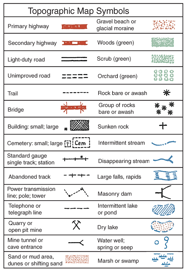
Contour lines: Light brown lines on a map that indicate height above sea level.
Declination: The direction in which the compass needle points. More accurately, its the angular difference between true north and magnetic north, or between grid north and magnetic north (called grid declination). Expressed in degrees east or west of the agonic line.
Declination diagram: A diagram in the legend of topographic maps that gives the value of the area declination.
Direction-of-travel arrow: An arrow inscribed on the plastic base plate of orienteering compasses points toward your objective when the compass is properly oriented (needle centered in the doghouse).
Doghouse: A slang term for the printed arrow inside the housing of orienteering compasses. When the dog is in the house (magnetic needle inside printed arrow of housing), the compass is properly oriented.
GPS (global positioning system) receiver: An electronic unit that receives positioning information off orbiting satellites. With a civilian GPS model, you can locate your position anywhere on Earth in a matter of minutes. Accuracy is 10 meters or less.
Grid lines: Interconnecting lines superimposed over the face of topographic maps.
Grid north: The direction the grid lines point with respect to true north.
Handrail: A topographic feature that you can follow to your objective, such as a road, river, creek, power line, trail, or lakeshore.
Housing: The part of the compass that contains the magnetic needle.
Index: A master map that contains information for ordering topographical maps. Also the place on a compass where the bearing is read.
Intercardinal points: Intermediate compass pointsnortheast, southeast, southwest, northwest.
Latitude: The distance in degrees north or south of the equator.
Longitude: The distance in degrees east or west of the prime meridian located at Greenwich, England.
Magnetic north: The direction the compass needle points.
Map aid lines: Parallel lines inside the housing of orienteering compasses. When these are aligned to map north, the compass will give a proper bearing you can follow on the ground.
Meridians: Same as lines of longitude. Meridians run true north and south.
North: There are three northstrue (geographic), magnetic (direction the compass needle points), and grid (direction the grid lines run).
Orienteering: Competitive sport combining cross-country running and compass directions to locate specific points (called controls) on the ground.
Parallels: Lines of latitude. These run parallel to the equator.
Planimetric map: A map that does not indicate elevation above sea level; Example: a common road map.
Protractor: A plastic arc used for measuring angles.
Scale: The relationship between map and ground distance. Expressed as a representative fraction, such as 1:250,000.
Symbols: Icons on maps that depict primarily man-made features.
Font size:
Interval:
Bookmark:
Similar books «Basic illustrated. Map and compass»
Look at similar books to Basic illustrated. Map and compass. We have selected literature similar in name and meaning in the hope of providing readers with more options to find new, interesting, not yet read works.
Discussion, reviews of the book Basic illustrated. Map and compass and just readers' own opinions. Leave your comments, write what you think about the work, its meaning or the main characters. Specify what exactly you liked and what you didn't like, and why you think so.