Dedicated to Jack my evening star.
May he never lose his way.
And Major safe in harbour now.
REEDS
Bloomsbury Publishing Plc
50 Bedford Square, London, WC1B 3DP, UK
This electronic edition published in 2020 by Bloomsbury Publishing Plc
BLOOMSBURY, REEDS and the Reeds logo are trademarks of Bloomsbury Publishing Plc
First published in 1993 by Thomas Reed Publications
Second edition 1995
Revised 1998
Third edition 2000
Reprinted 2002
Fourth edition published by Adlard Coles Nautical 2004
Fifth edition 2007
Sixth edition 2010
Seventh edition 2020
Copyright Malcolm Pearson, 1993, 1995, 2000, 2004, 2007, 2010, 2020
Copyright Andy Du Port, 2020
Illustrations Barbara McGavin and Dave Saunders
Malcolm Pearson and Andy Du Port have asserted their right under the Copyright, Designs and Patents Act, 1988, to be identified as Author of this work.
All rights reserved
You may not copy, distribute, transmit, reproduce or otherwise make available this publication (or any part of it) in any form, or by any means (including without limitation electronic, digital, optical, mechanical, photocopying, printing, recording or otherwise), without the prior written permission of the publisher. Any person who does any unauthorised act in relation to this publication may be liable to criminal prosecution and civil claims for damages.
Bloomsbury Publishing Plc does not have any control over, or responsibility for, any third-party websites referred to or in this book. All internet addresses given in this book were correct at the time of going to press. The author and publisher regret any inconvenience caused if addresses have changed or sites have ceased to exist, but can accept no responsibility for any such changes.
A catalogue record for this book is available from the British Library.
ISBN: 978-1-4729-7216-3 (PB)
ISBN: 978-1-4729-7215-6 (eBook)
ISBN: 978-1-4729-7214-9 (ePDF)
Original drawings by Sherrie Pearson
Note: While all reasonable care has been taken in the preparation of this publication, the author and publisher accept no responsibility for any errors or omissions or consequences ensuing upon the use of the methods, information or products described in the book.
To find out more about our authors and their books please visit www.bloomsbury.com where you will find extracts, author interviews and details of forthcoming events, and to be the first to hear about latest releases and special offers, sign up for our newsletters.

CONTENTS

INTRODUCTION
First published in 1993, this 7th edition Reeds Skippers Handbook has been thoroughly revised while maintaining the same layout and all the previous information.
Although we rely more and more on electronics for navigation, any electronic device in a small vessel, whether it be a GPS receiver, chart plotter, radar or AIS, is susceptible to damp, water, accidental damage or malfunction. A competent skipper must therefore be prepared to revert to traditional methods of navigation or risk the wrath of the crew if plans have to be changed because he/she lacks the knowledge or confidence to use a paper chart, a 2B pencil, a pair of dividers and a hand-bearing compass to fix the boats position and continue the passage safely.
Radar is, for many, an invaluable aid to navigation and collision avoidance, particularly in fog. However, a book of this size cannot hope to cover the subject in any depth, and you should hone your expertise by attending a recognised course and/or by studying one of the many excellent books on the subject.
I wish you safe and happy boating, under sail or power.
Andy Du Port
Acknowledgements
In recognition of the leading part played by the RYA in the promotion of safe practice for recreational boaters, it should be noted that many of the techniques explained in this book emanate from the RYA and are those routinely taught by RYA trained instructors to students enrolled on their navigation and seamanship courses.
The figures are based on or are reproduced from Admiralty Charts or publications with permission from The Controller of Her Majestys Stationery Office and the UK Hydrographic Office.
The life saving signals are based on material issued by the MCA and are reproduced with their kind permission.
Thanks to Practical Boat Owner for permission to reproduce material previously published in that magazine.
Finally, my special thanks to my wife Sherrie without whose help and artistic ability this book would not have been published.
NOTE: Every effort has been made to find the copyright holders of any material used in this book that is not the authors own.
Malcolm Pearson
POSITION AND DISTANCE
Latitude and longitude
Latitude and longitude
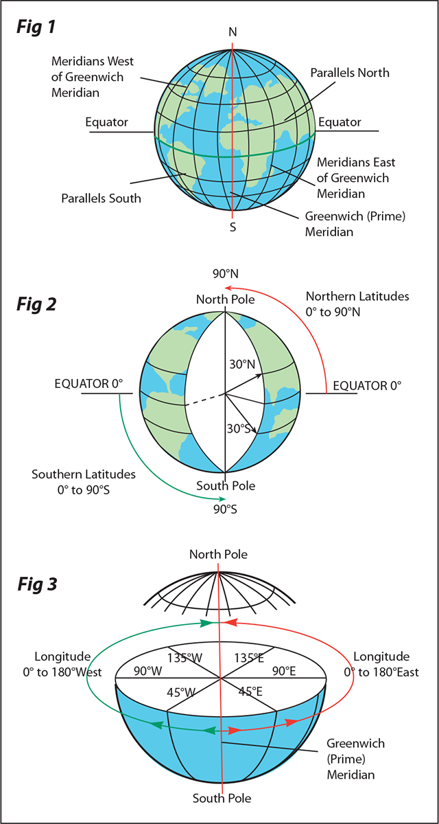
The network of lines seen on a globe of the world is used to define position on its surface. The horizontal lines are parallels of latitude and the vertical lines that converge at the poles are meridians of longitude ().
Latitude is measured, north or south, along a meridian from 0 (the Equator) to 90 (the Poles) ().
Longitude is measured, east or west, from 0 (Greenwich Meridian) to 180 ().
 Lines of latitude and longitude form complete circles around the globe. There are 360 in a circle and each degree can be divided into 60 minutes.
 Using these co-ordinates, any place on Earth can be precisely defined as a position of latitude and longitude.
 Latitude is always given first followed by longitude and, for coastal navigation, position is normally defined to the nearest minute. If greater accuracy is required, tenths of a minute may also be quoted, ie: Bishop Rock 4952.4N 00626.7W
Mercator projection
To show the Earth on a flat chart, Mercator projection is generally used. As with a globe, these charts are overprinted with lines of latitude and longitude but on a Mercator chart the meridians are parallel to each other. This distorts the landmasses in an east-west direction so, to preserve the shape of the land, the north-south distance between successive parallels of latitude is progressively increased towards each pole.
Mercator charts
Mercator charts and rhumb lines
The real value of Mercators projection is that although the scale of the landmasses is distorted, direction is unaffected. This means that a straight line drawn between any two positions on a Mercator chart will cross every meridian at the same angle, so the navigator has only to measure that angle to obtain the true course to follow from one position to the other ().






 Lines of latitude and longitude form complete circles around the globe. There are 360 in a circle and each degree can be divided into 60 minutes.