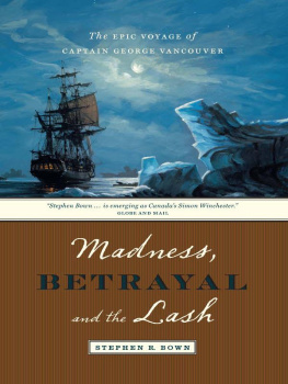
MADNESS, BETRAYAL AND THE LASH
The Epic Voyage of
Captain George Vancouver

The EPIC VOYAGE of
CAPTAIN GEORGE VANCOUVER
STEPHEN R. BOWN
madness,
BETRAYAL
and the Lash

D&M PUBLISHERS INC.
Vancouver/Toronto/Berkeley
Copyright 2008 by Stephen R. Bown
First paperback edition 2009 First U.S. edition 2010
09 10 11 12 13 5 4 3 2 1
All rights reserved. No part of this book may be reproduced, stored in a retrieval system or transmitted, in any form or by any means, without the prior written consent of the publisher or a licence from The Canadian Copyright Licensing Agency (Access Copyright). For a copyright licence, visit www.accesscopyright.ca or call toll free to 1-800-893-5777.
Douglas & McIntyre
A division of D&M Publishers Inc.
2323 Quebec Street, Suite 201
Vancouver BC Canada V5T 4S7
www.douglas-mcintyre.com
Library and Archives Canada Cataloguing in Publication
Bown, Stephen R
Madness, betrayal and the lash :
the epic voyage of Captain George Vancouver / Stephen Bown.
Includes bibliographical references.
ISBN 978-1-55365-339-4 (cloth) ISBN 978-1-55365-313-4 (paper)
1. Vancouver, George, 1757-1798. 2. Northwest Coast of North America
Discovery and explorationBritish. 3. ExplorersEngland
Biography. I. Title. II. Title: Epic voyage of Captain George Vancouver.
G246.V3B69 2008 910.92 C2008-901631-9
Editing by John Eerkes-Medrano
Copy editing by Iva Cheung
Jacket and text design by Jessica Sullivan
Front jacket illustration by John Horton
Back jacket portrait, believed to be of Captain George Vancouver
National Portrait Gallery, London
Printed and bound in Canada by Friesens
Printed on acid-free paper that is forest friendly (100% post-consumer
recycled paper) and has been processed chlorine free.
Distributed in the U.S. by Publishers Group West
We gratefully acknowledge the financial support of the Canada Council for the Arts, the British Columbia Arts Council, the Province of British Columbia through the Book Publishing Tax Credit and the Government of Canada through the Book Publishing Industry Development Program (BPIDP) for our publishing activities.
Contents


T HERE ARE NO people in view. Im standing on a small, pebble-strewn beach bounded at each end by giant rock outcroppings and hemmed in by a wall of mighty cedar trees. It is cold and raining. Mist clings to the treetops and obscures the surrounding mountains. The waves gently curl in towards my boots, so I step back, leaving a boot print in the pebbles. The beach is deserted and unremarkable, indistinguishable from thousands of other tiny, stone beaches along the rugged coast of the Pacific Northwest. I turn and walk through the drizzle, scramble over the rock outcropping and return to the larger beach and the grassy clearing above it. The clearing is the only level ground on this narrow spit of land that juts south from Nootka Island.
From my vantage point in the clearing, I now see two very different aspects of the same ocean. On one side of this narrow finger of land lies the open Pacific, its wild waves rumbling ominously with whitecaps before they crash into the shore. The other side is as calm and placid as a lake, the finger of land subduing the rough water and creating a snug shelter. The boat I arrived on is moored here on the calm side, in Yuquot or Friendly Cove, where dozens of ships once sought shelter. For a brief period in the late eighteenth century, this remote and lonely spot on the southern tip of the largest island west of Vancouver Island was one of the most important and talked-about places in the world: more than a thousand people lived here. The deserted beach I strolled on so recently had commercial storage sheds and workshops that, although primitive, serviced activities that changed the course of empires. The grassy clearing at one time supported dozens of enormous cedar longhouses of the Mowachaht people and, during another, briefer time, a Spanish settlement and garrisonthe northernmost outpost of Spains vast American empire.
In the late 1800s, after centuries of European naval exploration and particularly after the three great voyages of Captain James Cook, most of the worlds coastline, apart from its Arctic and Antarctic coasts, was reasonably well charted. The other remaining blank spot was the Pacific coast of North America. In the wake of Cooks hasty voyage along this coast in 1778 came a discovery that would dramatically change the course of history: sea otter pelts, which were worth a fortune in China. Within a few years, dozens of American and British ships were cruising the coast in search of the velvet booty. It was also somewhere along this vast unexplored coast that armchair geographers had decided to place the elusive western end of a northwest passage connecting the Pacific Ocean to Hudson Bay or to a great inland sea in the uncharted continental interior. Pacific North America was a wild card in the game of empire, a tectonic struggle for global supremacy between the nations of western Europe. Controlling the Pacific coast, or at least preventing others from controlling it, was suddenly very important. Spain claimed the territory outright as part of its New World empire and forbade any trespassing, a claim based on the historical precedent of the Treaty of Tordesillas, signed in 1494. Britain maintained that the seas should be open to every nation for trade and commerce. These two views were of course incompatible.
The stakes were dramatically upped in the summer of 1789, in Friendly Cove in Nootka Sound, when a Spanish captain captured several trespassing British trading ships and sent their officers and crews to Mexico as prisoners. The Spanish seizure of British ships and property incited a patriotic outcry in Englandafter Captain Cooks glorious navigation and charting of the Pacific, people asked, how could the Spanish dictate where British ships could sail and trade? Slogans were chanted, the rhetoric escalated, troops and warships were mobilized. The clash brought two great empires to the brink of war. The reluctant and temporary peace that followed inspired one of the great eighteenth-century voyages of exploration, an epic adventure that was to last nearly five years and change the histories and geographies of Spain, Russia, Britain, Hawaii, the new republic of the United States of America, the yet-to-exist country of Canada and dozens of First Nations.
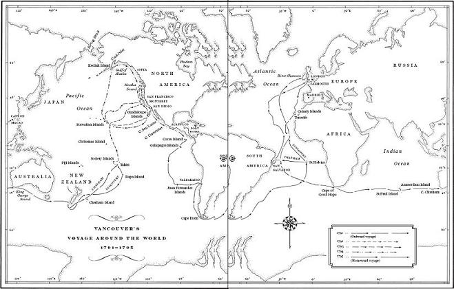
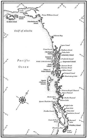
In 1790 the British government commissioned two small ships, Discovery and Chatham, to circumnavigate the world, sail to Friendly Cove and meet with a Spanish representative to ratify the terms of a boundary agreement between the two empires. The British leader of the expedition was also commissioned to do something far more daunting and ultimately far more important: complete a detailed nautical survey of the uncharted coast from California to Alaska, settling the issue of the legendary east-west passage south of the Arctic, and compile a detailed report on the region, its peoples and its resources. What was its potential as an outpost of the British Empire?
Next page
