Barrett - The Hebridean Way
Here you can read online Barrett - The Hebridean Way full text of the book (entire story) in english for free. Download pdf and epub, get meaning, cover and reviews about this ebook. year: 2017, publisher: Cicerone Press, genre: Home and family. Description of the work, (preface) as well as reviews are available. Best literature library LitArk.com created for fans of good reading and offers a wide selection of genres:
Romance novel
Science fiction
Adventure
Detective
Science
History
Home and family
Prose
Art
Politics
Computer
Non-fiction
Religion
Business
Children
Humor
Choose a favorite category and find really read worthwhile books. Enjoy immersion in the world of imagination, feel the emotions of the characters or learn something new for yourself, make an fascinating discovery.
- Book:The Hebridean Way
- Author:
- Publisher:Cicerone Press
- Genre:
- Year:2017
- Rating:3 / 5
- Favourites:Add to favourites
- Your mark:
The Hebridean Way: summary, description and annotation
We offer to read an annotation, description, summary or preface (depends on what the author of the book "The Hebridean Way" wrote himself). If you haven't found the necessary information about the book — write in the comments, we will try to find it.
Barrett: author's other books
Who wrote The Hebridean Way? Find out the surname, the name of the author of the book and a list of all author's works by series.


The Hebridean Way — read online for free the complete book (whole text) full work
Below is the text of the book, divided by pages. System saving the place of the last page read, allows you to conveniently read the book "The Hebridean Way" online for free, without having to search again every time where you left off. Put a bookmark, and you can go to the page where you finished reading at any time.
Font size:
Interval:
Bookmark:
Richard Barrett first visited the Outer Hebrides in the early 1970s, before many of the smaller islands were connected to their larger neighbours by causeways and when most of the roads were single track. Having become immediately besotted, he spent most holidays walking all over the islands and for a number of years lived in North Harris, where he and his wife ran a guest house.
He spent his working life as a professional marketer with a number of multinational organisations in the UK and abroad, but still found time for recreational climbing, winter mountaineering, sea kayaking and latterly cycling. Today, hes a city dweller, but still makes frequent forays to the Hebrides, reconnecting with the wilderness and catching up with old friends.
Cycling in the Hebrides
Cycling in the Lake District
Walking on Harris and Lewis
THE HEBRIDEAN WAY
LONG-DISTANCE WALKING ROUTE THROUGH SCOTLANDS OUTER HEBRIDES
by Richard Barrett

2 POLICE SQUARE, MILNTHORPE, CUMBRIA LA7 7PY
www.cicerone.co.uk
Richard Barrett 2017
First edition 2017
ISBN: 978 1 85284 727 2
Printed in China on behalf of Latitude Press Limited
A catalogue record for this book is available from the British Library.
 Crown copyright OS PU100012932
All photographs are by the author unless otherwise stated.
My thanks to the staff of Comhairle nan Eilean Siar (the Western Isles Council) and Scottish Natural Heritage for helping clarify parts of the route that were yet to be waymarked when I walked them in 2015 and 2016. As ever, I should also thank Jonathan and the team at Cicerone, who were a delight to work with and whose sound guidance notes made delivering the manuscript and accompanying photographs a pleasure.
While every effort is made by our authors to ensure the accuracy of guidebooks as they go to print, changes can occur during the lifetime of an edition. Any updates that we know of for this guide will be on the Cicerone website (www.cicerone.co.uk/727/updates), so please check before planning your trip. We also advise that you check information about such things as transport, accommodation and shops locally. Even rights of way can be altered over time. We are always grateful for information about any discrepancies between a guidebook and the facts on the ground, sent by email to updates@cicerone.co.uk or by post to Cicerone, 2 Police Square, Milnthorpe LA7 7PY, United Kingdom.
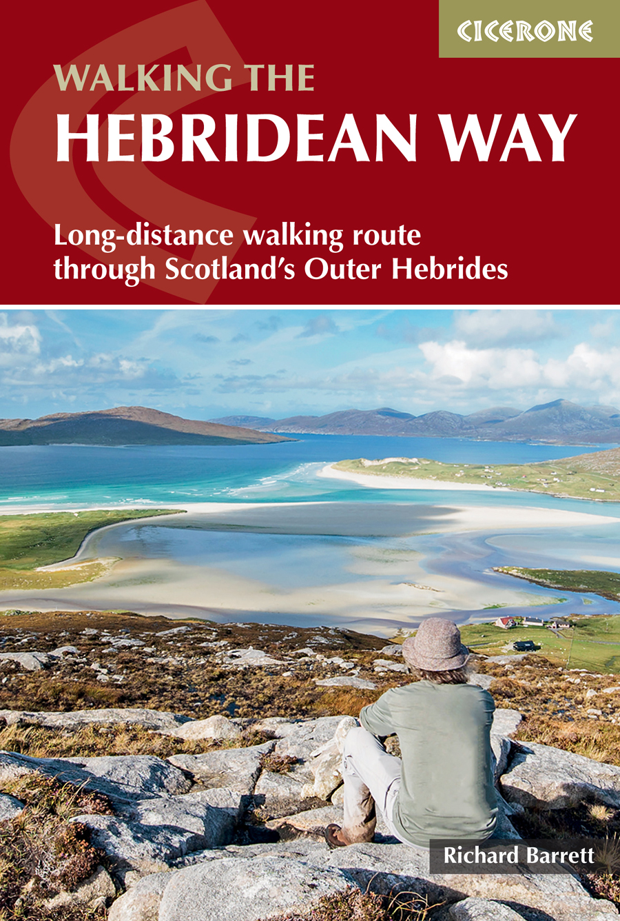
Front cover: Looking across to Taransay from the summit of Carran in South Harris (Stage 7)
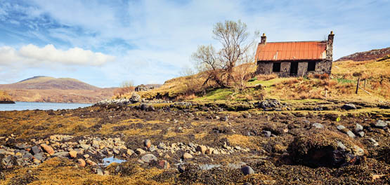
Abandoned cottage at Eilean Anabeich (Stage 8)
An Cliseam (799m), the highest summit in the Western Isles, with a covering of snow (Stage 8)
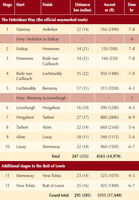
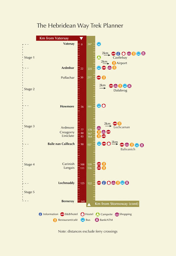
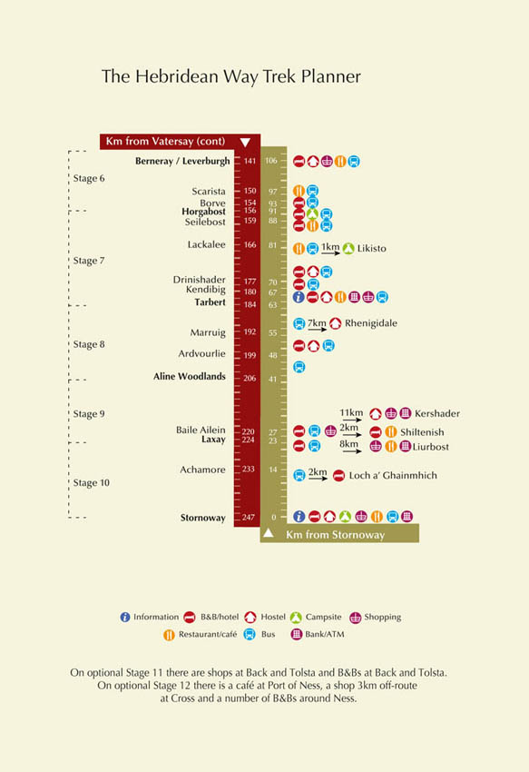
Note: distances do not include diversions to overnight stops away from the path.
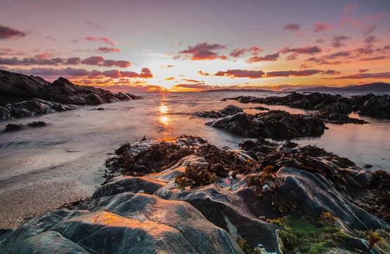
A sunset from Trigh Scarasta in South Harris (Stage 6)
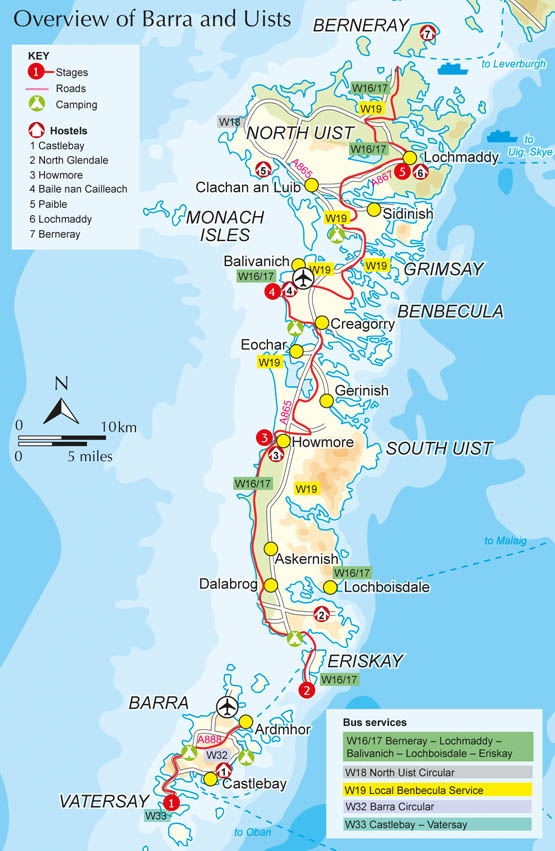
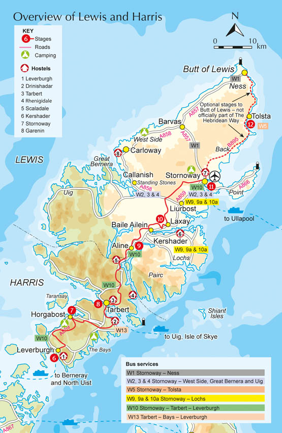
Opened by Scottish Natural Heritage in 2017, the Hebridean Way stretches 247km (155 miles) along the length of the Outer Hebrides from Vatersay (Bhatarsaigh) in the south to Stornoway (Steornabhagh) in the north. The route crosses 10 islands linked by six causeways and two ferries and if these numbers do not appear to add up it is because the so-called Isles of Harris (Na Hearadh) and Lewis (Ledhas) share the same landmass. The route traverses a variety of different terrains, passing over rugged hills, along dazzling white shell beaches and across seemingly empty moorland.
The stunning landscape, varied geology, exceptional wildlife and numerous antiquities of the Outer Hebrides are truly awe-inspiring. The Outer Hebrides retain a distinctive culture too, with Gaelic often spoken as a first language in many communities.
Unlike many other long-distance paths, there is considerable variety along the way. The terrain can change rapidly. In the morning you can be walking across a wild moor, then in the afternoon along a blindingly white beach beside turquoise seas. There are also cultural differences. The islands at the southern end of the chain are predominantly Catholic and their communities are considerably more relaxed about religious observance on Sundays. Their leisure centres and supermarkets open on Sundays, which is in total contrast with the mainly Presbyterian islands of Harris and Lewis, where communities are far stricter in observing the Sabbath.
Getting there and getting about means that the Hebridean Way is not the easiest long-distance path in terms of logistics, although there are plenty of tips and advice packed into this guidebook. But it is a jewel that you will remember every time you see a map of the UK.
At the moment, the Hebridean Way is a work in progress. The route currently finishes at Lews Castle in Stornoway. However, once further funding becomes available, there are plans to extend the route all the way up to the Butt of Lewis (Rubha Robhanais), with options running up both the west and east coasts of Lewis. Once they are constructed, these extensions will be incorporated into future editions of this book. But for the moment, two additional stages are included between Stornoway and the Butt of Lewis, making best use of existing paths.
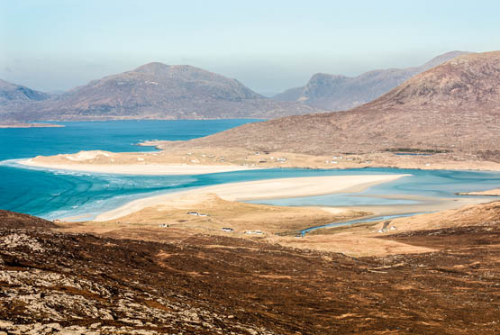
The hills of North Harris from near the summit of Carran (Stage 7)
A quick look at a map shows that the majority of settlements in the Outer Hebrides are on the coast, surrounded by a fertile patch of land for growing crops and grazing cattle but with safe access to the sea, which remained the main form of transportation until the early 20th century. In 1804 and 1805, William Bald produced detailed maps of Harris and South Uist (Uibhist a Deas) respectively, showing numerous paths linking the coastal villages; but the only tracks or roads marked are one linking Leverburgh (An t-Ob) with Rodel (Roghadal) on Harris, and another running the length of the fertile, low-lying grassland (machair) on South Uist.
Font size:
Interval:
Bookmark:
Similar books «The Hebridean Way»
Look at similar books to The Hebridean Way. We have selected literature similar in name and meaning in the hope of providing readers with more options to find new, interesting, not yet read works.
Discussion, reviews of the book The Hebridean Way and just readers' own opinions. Leave your comments, write what you think about the work, its meaning or the main characters. Specify what exactly you liked and what you didn't like, and why you think so.