Lincolnshire
Railways
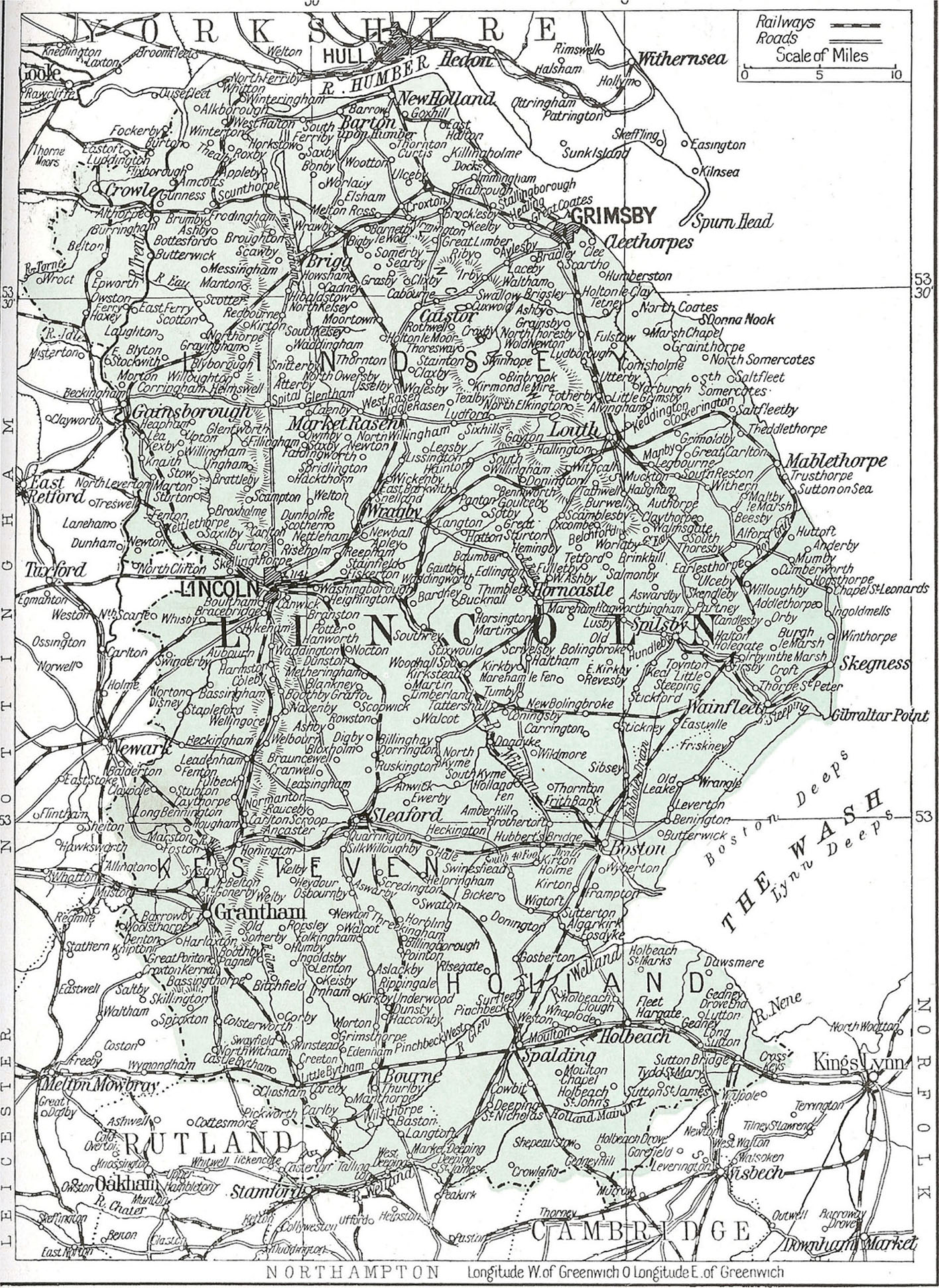
Railway map of Lincolnshire in 1920 at the peak of the system. The only lines not shown are the Edenham and Little Bytham Railway and the Alford and Sutton Tramway, both of which closed before the end of the nineteenth century.
Lincolnshire
Railways
ALAN STENNETT

THE CROWOOD PRESS
First published in 2016 by
The Crowood Press Ltd
Ramsbury, Marlborough
Wiltshire SN8 2HR
www.crowood.com
This e-book first published in 2016
Alan Stennett 2016
All rights reserved. No part of this publication may be reproduced or transmitted in any form or by any means, electronic or mechanical, including photocopy, recording, or any information storage and retrieval system, without permission in writing from the publishers.
British Library Cataloguing-in-Publication Data
A catalogue record for this book is available from the British Library.
ISBN 978 1 78500 083 6
All images are from the authors collection unless otherwise stated.
Contents
Introduction and Acknowledgements
It has been a great privilege to be asked to write this description of the railways of Lincolnshire, but it would not have been possible without all the work that has been put in, and continues to be done, by many authors and local railway historians. Large numbers have worked on various local projects but special mention must be made of Alf Ludlam, Stewart Squires, John Rhodes, Stephen Walker, C. T. Goode and the late John Ruddock, whose works have been particularly valuable.
Pictures have come from many sources, and I can only hope that due credit has been given for all those that have been used. I have been particularly grateful to John Foreman, Stuart Ray, Michael Barratt, John Meredith, Graham Lightfoot, M. Cook, Ray Heppenstall, John Fisher, David and John Ford, Brian Rose, Richard Goodman, P. Loftis and Jack Overton or to their friends or families for permission to use some of their original works.
I have also been fortunate to be able to make use of the collections held by David Robinson, Rod Knight, John Musselwhite, Stuart Gibbard, Bryan Longbone and Mrs Scott, as well as for material held in the archives of the National Railway Museum, and of Lincolnshire, North-East Lincolnshire and North Lincolnshire Councils.
Every effort has been made to ensure that copyright material has been approved and acknowledged in this book. Any errors and oversights should be referred to the writer, and will be corrected in later editions
I am very grateful to Rod Knight, Adam Cartwright and Mike Hartley for their efforts to ensure that I have not made too many silly errors, but I should add that any that remain are entirely my responsibility.
I must also thank Sue, my wife, for her tolerance at various times during the writing and compilation of this work and for her continuing interest in railways, despite my not entirely keeping my promise that we would not live in a museum when we moved into Woodhall Junction!
CHAPTER 1
Lincolnshire Before the Railways
A Difficult County for Travellers
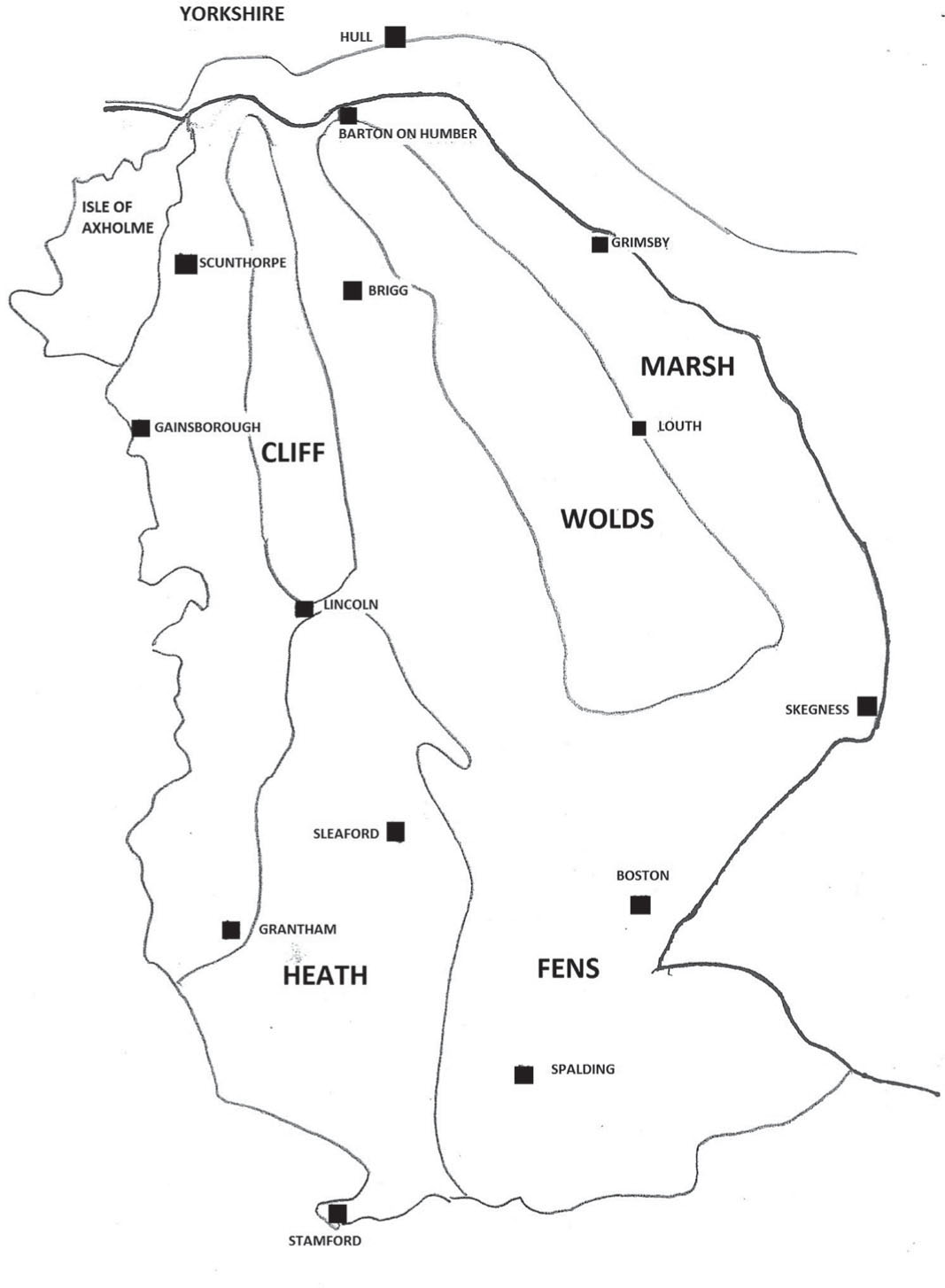
General topography of Lincolnshire.
Communications in Lincolnshire before the railways was a matter of ancient routes and even older waterways. Our main highways still follow the roads that the Romans built two millennia ago, and a county where much of the land was frequently inundated found water transport an invaluable and sometimes essential way to get around.
This historic county has always presented difficulties to the traveller. The large areas of the Fens in the south-east, the Carrs of the Isle of Axholme at the opposite corner, and the marshes along much of the coast were constantly changing areas of mud, water and soggy bits of land, with few easily discernible ways through them. Most land routes, therefore, followed the limestone spine of the Heath and Cliff or the higher lands of the chalk Wolds in the north-east.
The influence of the Romans is very clear. The major northsouth route within the county follows parts of Ermine Street, King Street and Mareham Lane from near Peterborough, through Sleaford and Lincoln, to the Humber close to Winteringham. The A46, still the main access to Lincoln from the west, follows the line of the Fosse Way as it strikes diagonally from Newark through Lincoln towards the north-eastern coast. From Lincoln to the coast, the road curves around the northern edge of the Fens to the Roman Banovallum Horncastle then on towards Wainfleet and what may well have been a Roman port, now lost to the sea, near Skegness. Other key routes include Tillbridge Lane, from just north of Lincoln to what was a ford over the Trent at Marton; more of Ermine Street through Ancaster towards Stamford; and the Salt or Salters Way now the A52 from near Grantham across the Bridge End Causeway to Donington, then towards the salt workings on the coast or in the marshes. It may also have served a port in Bicker Haven, then open to the sea.
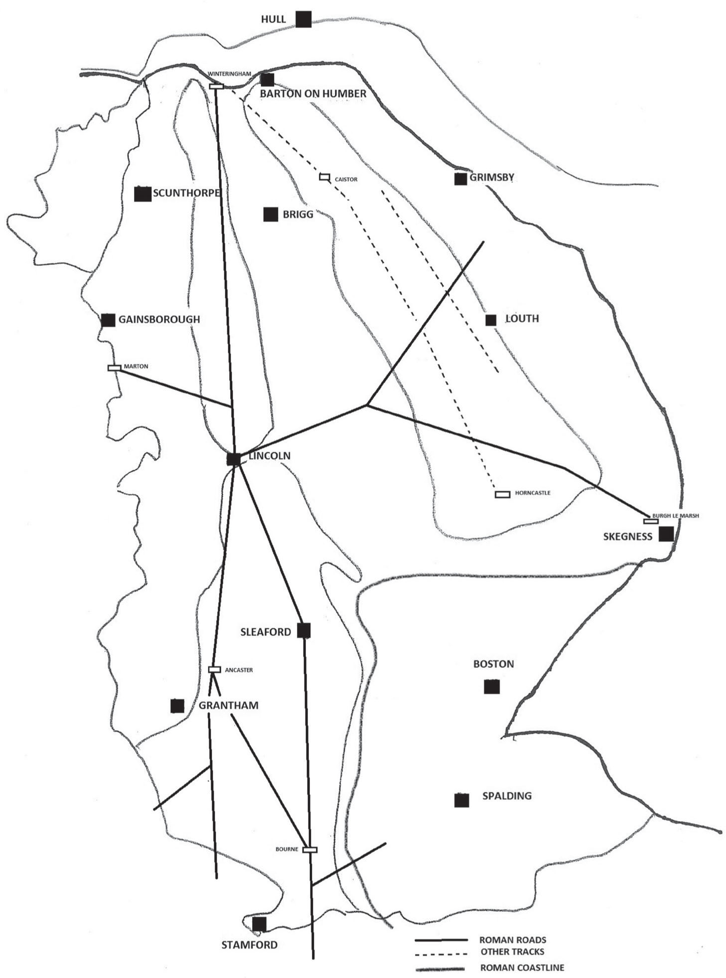
Roman and other old routes in Lincolnshire.
Many other Roman roads and tracks have been identified, but it is likely that a number of them followed existing Iron Age or earlier track-ways. The Salt Way was almost certainly pre-Roman, and although the arrow-straight line of Ermine Street suggests that it was new in Roman times, it closely follows the older Jurassic Way cliff-edge paths of Middle Street and Pottergate. Caistor High Street, running north from Horncastle to Caistor, is almost certainly pre-Roman, as are the Bluestones Heath Road and Bartongate, along the edge of the Marsh. Mareham Lane could also have been in use before the Roman occupation.
Where the Iron Age salt merchants and the Roman legions failed to penetrate on land, they, and the locals, took to the water. The Witham itself, running north from near Grantham before turning through the Lincoln Gap then south to the Wash, with its tributaries the Slea, the Bain and the Brant, would have been the main water highway into, and around, the county; but the other fenland rivers Welland, Glen and Nene remained important routes well into modern times. In the north, the Ancholme, the Trent and the Idle were all significant waterways, but a great deal of water traffic would simply have been along the creeks and lagoons of the Fens and marshes. Lincolns museum, the Collection, has a fine log boat found in the muds of the Witham, along with records of many similar vessels, and archaeological finds such as the Witham Shield, now in the British Museum, suggest that the waterways of the county had a strong religious significance, as well as facilitating travel in the county.
The Romans also made good use of the waterways, constructing the Foss Dyke linking the Witham at Lincoln and the Trent near Torksey. They are also the most probable diggers of the long cut known as the Carr Dyke, running along the fen edge from near Peterborough to Lincoln. It seems likely this was mainly a catch-water drain, taking water coming off the higher land to prevent it flooding into the Fens, which appear to have been drier in Roman times. It may have been used for transport, but the evidence is scanty. Excavations in Lincoln show it was an important centre for waterborne transport. Bawtry, on the Idle, was also a Roman port; Spalding and Bourne may well have been, and there seems little doubt that they made good use of the fenland waterways as well.

