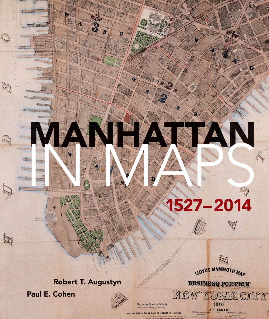
Paul E. Cohen - Manhattan in Maps 1527–2014
Here you can read online Paul E. Cohen - Manhattan in Maps 1527–2014 full text of the book (entire story) in english for free. Download pdf and epub, get meaning, cover and reviews about this ebook. year: 2014, publisher: Dover Publications, genre: Romance novel. Description of the work, (preface) as well as reviews are available. Best literature library LitArk.com created for fans of good reading and offers a wide selection of genres:
Romance novel
Science fiction
Adventure
Detective
Science
History
Home and family
Prose
Art
Politics
Computer
Non-fiction
Religion
Business
Children
Humor
Choose a favorite category and find really read worthwhile books. Enjoy immersion in the world of imagination, feel the emotions of the characters or learn something new for yourself, make an fascinating discovery.
- Book:Manhattan in Maps 1527–2014
- Author:
- Publisher:Dover Publications
- Genre:
- Year:2014
- Rating:5 / 5
- Favourites:Add to favourites
- Your mark:
Manhattan in Maps 1527–2014: summary, description and annotation
We offer to read an annotation, description, summary or preface (depends on what the author of the book "Manhattan in Maps 1527–2014" wrote himself). If you haven't found the necessary information about the book — write in the comments, we will try to find it.
More than 400 years of history unfold in the pages of this lavishly illustrated volume, which presents sixty-five full-color maps of Americas oldest major city. This is Manhattans first atlas of historical maps, gathered from private collections and libraries throughout the world. From Giovanni da Verrazzanos first glimpse of New York Harbor in the sixteenth century to a modern aerial survey of the island, these rare and beautiful maps recount the citys urban and social history.Each map is accompanied by a fascinating essay that explores its portrait of New Yorks changing physical and social contours. Examples from the Dutch colonial period reflect the findings of Manhattans earliest European settlers. New York was the command center for British forces during the Revolution, and wartime maps painstakingly delineate the battlegrounds streams, swamps, hills, and shoreline. Frederick Law Olmsted and Calvert Vauxs original plan for Central Park appears here, along with charts that reveal the development of the Manhattan grid as well as the expansion of ethnic neighborhoods, midtown vice, and the subway system. Each entry cites the maps title, date of creation and publication, cartographer, medium, and the institution or private collection where the map is archived. There is a Foreword by Tony Hiss, a bibliography, and complete index, as well as a new Introduction by Marguerite Holloway, author of The Measure of Manhattan (2013), and an essay by landscape ecologist Eric W. Sanderson, which includes a map by Mr. Sanderson and cartographer Markley Boyer providing a view of Manhattan Island as Henry Hudson might have seen it in 1609. Here then is the story of Manhattan as it was, as it is, and even as it might have been. Maps tell the story. All the output of all the journalists who have written about Manhattan does not succeed half as well.Ted Koppel, former managing editor and anchor, NightlineManhattan in Maps enables us all to look through layers of time and concrete to the ground of life in this city through over three centuries. . . . an invaluable visual guide to New York City history.Alice C. Hudson, Chief, Map Division, Center for Humanities, The New York Public Library
Paul E. Cohen: author's other books
Who wrote Manhattan in Maps 1527–2014? Find out the surname, the name of the author of the book and a list of all author's works by series.


Manhattan in Maps 1527–2014 — read online for free the complete book (whole text) full work
Below is the text of the book, divided by pages. System saving the place of the last page read, allows you to conveniently read the book "Manhattan in Maps 1527–2014" online for free, without having to search again every time where you left off. Put a bookmark, and you can go to the page where you finished reading at any time.
Font size:
Interval:
Bookmark:


Paul E. Cohen Robert T. Augustyn
Foreword by
Tony Hiss
New Introduction by
Marguerite Holloway
Manhattan As It Once Was by
Eric W. Sanderson
DOVER PUBLICATIONS, INC.
Mineola, New York
FOR PHYLLIS, KATIE & WILL
Copyright
Copyright 1997 by Paul E. Cohen and Robert T. Augustyn
Foreword copyright 1997 by Tony Hiss
New Introduction to the Dover edition copyright 2014 by Marguerite Holloway Essay
Manhattan As It Once Was copyright 2014 by Eric W. Sanderson
All rights reserved.
Bibliographical Note
Manhattan in Maps 15272014, first published by Dover Publications, Inc., in 2014, is an unabridged republication of the work originally published by Rizzoli International Publications, Inc., New York, in 1997. A new Introduction by Marguerite Holloway and an essay, "Manhattan As It Once Was, by Eric W. Sanderson, with an accompanying graphic illustration by Mr. Sanderson and Markley Boyer, have been specially prepared for the Dover edition.
International Standard Book Number
eISBN-13:978-0-486-79941-4
Manufactured in the United States by Courier Corporation
77991201 2014
www.doverpublications.com
CONTENTS
by Tony Hiss
by Marguerite Holloway
by Eric W. Sanderson
DISCOVERING MANHATTAN
THE DUTCH IN NEW AMSTERDAM
AN ENGLISH COLONY
REVOLUTIONARY WAR BATTLEGROUND
RECOVERY AND PLANNING
GROWTH WITHIN THE GRID
WORLDS WITHIN THE CITY
This book has been in the works for several years, and we have been helped and encouraged by many people along the way. Our biggest debt of gratitude goes to Asher Jason, our agent, and Alice Hudson, the head of the Map Division at The New York Public Library. They both had great faith in our project and on several occasions rescued it from oblivion. Alice Hudson is the best-informed curator of New York City maps, and she is exceedingly generous in sharing her knowledge and providing assistance.
Many librarians helped in acquiring photographs and locating facts and details about the maps in their collections. At the Library of Congress we have relied on the expertise of Ralph Ehrenberg, Gary Fitzpatrick, Jim Flatness, and Ron Grim. Mariam Touba of the New-York Historical Society was always ready to drop whatever she was doing to assist with the remarkable resources at that institution. Tony Campbell of the British Library made valuable suggestions, and the staff of the map department helped us acquire transparencies of the many important New York City maps in England. Jim Corsaro of the New York State Library informed us about maps we otherwise would have missed. We were constantly calling upon the librarians at The New York Public Library: Roberta Waddell of the Print Room, Jennifer Lee of the Rare Book Department, and Tom Bourke of the Map Division. We were in regular communication with Nancy Kandoian of the Map Division of The New York Public Library, who fielded our many questions with agility.
We have enjoyed many months of working with David Morton and Megan McFarland of Rizzoli International Publications; we thank them for their perceptive suggestions, long hours of work, and indulgence with us. We also wish to thank our first editor on this project, Alan Axelrod, who was one of the first to recognize the merit in a book about New York City maps.
Our colleagues and coworkers have supported and put up with us as we toiled away on Manhattan maps: Richard Arkway, Richard Lan, Seyla Martayan, Engela Brondum, Mead Cain, Anne De Mare, Seth Fagen, Ben Jones, Milton Mendez, and Jennifer Woodward.
We thank Richard Brown, Bill Ginsberg, Robert Goelet, Norman Hubbard, Joep De Koning, Allison Eckardt Ledes, Glen McLaughlin, Kenneth and Brian Quintenz, David Rumsey, Donald Schnabel, Arthur O. Sulzberger, Sr., Chase Viele, and Charles Wendell.
We would like generally to thank the private collectors we work with every day, whose interest and curiosity are in many ways the inspiration for this book.
We have also called upon Barbara Cohen of New York Bound Bookstore; Bob Lorenzson, photographer extraordinaire; Lynn de Marco, Bruce Altshuler, Jean Ashton, Georges Cohen, Joseph Montebello, Deborah Nadler, John Tauranac, Louis De Vorsey, and the late Constance Cohen, who would loved to have seen this book.
In many ways New York City conceals its past. Even though it is in fact Americas oldest major city, Boston and Philadelphia, which still preserve many of their colonial buildings, feel older. In New York there is almost no physical evidence of the citys long colonial history from the period 16251783. Several conflagrations and the citys need to build ever taller buildings in order to expand have all but obliterated structures built before 1800. Even less evident on the slender island of Manhattan, now almost entirely covered with pavement and cement, is a sense of the natural world, or indications of what the island was like prior to development.
Yet an avenue to New Yorks past does exist, though it is one that is relatively unknown: the history of the city through maps. No other medium provides, at a glance, so many vital clues to reconstructing the past. Some of the oldest maps preserve on paper the virgin landscape of Manhattan with its lakes, streams, and hills. Others follow the evolution of the island over the centuriesfrom the promising harbor on a sixteenth-century Italian map, to Dutch trading outpost, then to village, city, and finally, metropolis. It is only through maps that we can see this story unfold so graphically.
Despite the wealth of material and the intriguing subject, there has never been an illustrated book devoted exclusively to the mapping of Manhattan. Many of the maps that follow have not been reproduced before; others have not been reproduced for almost a century. It should be pointed out that at the beginning of the twentieth century, I. N. Phelps Stokes first published many of the important maps of New York City in a work that all students of Manhattan must acknowledge: the six-volume Iconography of Manhattan Island (19151928). Stokess Iconography has been called the greatest single reference work about any American city, and the numerous references to him throughout this book are a testament to our indebtedness to his remarkable research.
Stokes had one of the worlds best collections of prints and maps relating to America (it is now housed at The New York Public Library) and ultimately he compiled the most thorough book on the subject. Despite its excellence, the Iconography is cumbersome to use, has long been out of print, and its reproductions are unsatisfactory by current standards. We felt that a new book should present the maps individually and in color and include items uncovered since Stokes or not reproduced by him. Frederick Law Olmsted and Calvert Vauxs original plan for Central Park, Greensward, (see p. 118) has never been published before in color, and John Randel, Jr.s original manuscript of New Yorks comprehensive plan for the citys development, The Commissioners' Plan of 1811 (see p. 86) has not been photographed since Stokes. In addition, we have tried to expand the commentary that many of these maps have received to date. By learning as much as we could about the circumstances under which each map was created, we have been able to present them as multifaceted works that record much more than simple geographical data.
Next pageFont size:
Interval:
Bookmark:
Similar books «Manhattan in Maps 1527–2014»
Look at similar books to Manhattan in Maps 1527–2014. We have selected literature similar in name and meaning in the hope of providing readers with more options to find new, interesting, not yet read works.
Discussion, reviews of the book Manhattan in Maps 1527–2014 and just readers' own opinions. Leave your comments, write what you think about the work, its meaning or the main characters. Specify what exactly you liked and what you didn't like, and why you think so.