William Ascarza - Chiricahua Mountains: History and Nature
Here you can read online William Ascarza - Chiricahua Mountains: History and Nature full text of the book (entire story) in english for free. Download pdf and epub, get meaning, cover and reviews about this ebook. year: 2014, publisher: Arcadia Publishing Inc., genre: Romance novel. Description of the work, (preface) as well as reviews are available. Best literature library LitArk.com created for fans of good reading and offers a wide selection of genres:
Romance novel
Science fiction
Adventure
Detective
Science
History
Home and family
Prose
Art
Politics
Computer
Non-fiction
Religion
Business
Children
Humor
Choose a favorite category and find really read worthwhile books. Enjoy immersion in the world of imagination, feel the emotions of the characters or learn something new for yourself, make an fascinating discovery.
- Book:Chiricahua Mountains: History and Nature
- Author:
- Publisher:Arcadia Publishing Inc.
- Genre:
- Year:2014
- Rating:4 / 5
- Favourites:Add to favourites
- Your mark:
Chiricahua Mountains: History and Nature: summary, description and annotation
We offer to read an annotation, description, summary or preface (depends on what the author of the book "Chiricahua Mountains: History and Nature" wrote himself). If you haven't found the necessary information about the book — write in the comments, we will try to find it.
With elevations above nine thousand feet,dense vegetation and unique rock formations, the Chiricahua Mountains are aunique wildlife refuge and natural botanic reserve. Inhabited by Apaches and thenhomesteaders, the U.S. Cavalry, miners, outlaws and tourists, this range hasretained its allure through time. Apache legend Geronimo surrendered in 1886 toGeneral Nelson Miles in Skeleton Canyon, on the east side of the Chiricahuas inthe neighboring Peloncillo Mountains. JohnnyRingo and Curly Bill Brocius led the outlaws in the short-lived town of Galeyville. ChiricahuaNational Monument was created in 1924, andthe Civilian Conservation Corps arrived in the 1930s to build trails, rockstructures and fire lookouts. Join author William Ascarza as he tours thenatural and human histories of this magnificent Arizona mountain range.
William Ascarza: author's other books
Who wrote Chiricahua Mountains: History and Nature? Find out the surname, the name of the author of the book and a list of all author's works by series.


Chiricahua Mountains: History and Nature — read online for free the complete book (whole text) full work
Below is the text of the book, divided by pages. System saving the place of the last page read, allows you to conveniently read the book "Chiricahua Mountains: History and Nature" online for free, without having to search again every time where you left off. Put a bookmark, and you can go to the page where you finished reading at any time.
Font size:
Interval:
Bookmark:

Published by Natural History Press
A Division of The History Press
Charleston, SC 29403
www.historypress.net
Copyright 2014 by William Ascarza
All rights reserved
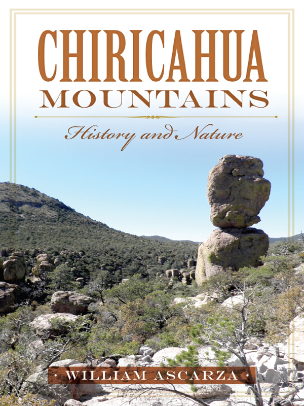
Front cover: Looking north toward Sugarloaf Mountain across the wonderland of standing-up rocks. Courtesy of William Ascarza.
First published 2014
e-book edition 2014
ISBN 978.1.62584.735.5
Library of Congress Cataloging-in-Publication Data
Ascarza, William.
The Chiricahua Mountains : history and nature / William Ascarza.
pages cm
Includes bibliographical references.
print edition ISBN 978-1-60949-800-9
1. Chiricahua Mountains (Ariz.)--History. 2. Natural history--Arizona--Chiricahua Mountains. I. Title.
F817.C5A83 2014
979.153--dc23
2013050305
Notice: The information in this book is true and complete to the best of our knowledge. It is offered without guarantee on the part of the author or The History Press. The author and The History Press disclaim all liability in connection with the use of this book.
All rights reserved. No part of this book may be reproduced or transmitted in any form whatsoever without prior written permission from the publisher except in the case of brief quotations embodied in critical articles and reviews.
Contents
Acknowledgements
A special thank you goes out to Amerind Foundation; Arizona Daily Star; Arizona Geological Survey; Arizona Historical Society; Arizona-Sonora Desert Museum; Arizona State Museum; Armando M. Arvizu; Kevin Bays; Bisbee Mining & Historical Museum; Dan Caudle; my wife, Lorie Cavalli; Chiricahua Desert Museum; Chiricahua National Monument; Chiricahua Regional Museum & Research Center; Tom and Alicia Davidson; Douglas Historical Society; Flandrau Planetarium and Science Center; Fort Bowie National Historic Site; Freeport-McMoRan; Friends of the Pima County Public Library; Hardin-Simmons Photograph Collection; Henry F. Hauser Museum; Kyle E. Johnson; Library of Congress Prints and Photographs Division; Larry Ludwig; the late Orville Mickens and his Frontier Relics Museum; Suzanne Moody; National Archives and Records Administration; National Park Service Harpers Ferry Center Collections; Rex Allen Arizona Cowboy Museum; Santa Cruz Island Foundation; Sierra Vista Historical Society; Slaughter Ranch Johnson Historical Museum of the Southwest; United States Department of Agriculture; University of Arizona Library; U.S. Navy National Museum of Naval Aviation; Rafael Velasco; and Western Archaeological Conservation Center.
Introduction
The Chiricahua Mountains are an undiscovered country in southeastern Arizona. Pronounced cheery-cow-ah, the name Chiricahua may have been derived from an Opata Indian word, Chiguicagui, which means mountain of the wild turkeys. To the Apache, the Chiricahua Mountains were defined as Big Mountain. The term Cherry Cows was a corruption of Chiricahua. The term dated back to the early 1880s, having been used at times to refer to the mountain range, the Apache, the twenty thousand head of cattle that roamed nearby the range in the 1920s and also a mining camp.
The Chiricahua Mountains are a remote mountain range in Arizona located 125 miles southeast of Tucson. Composed of unique rock formations, elevation gains of over nine thousand feet above sea level and dense vegetation, the Chiricahua Mountains are a significant sky island harboring diverse wildlife and unique plant species. Inhabited at various times by Apache, homesteaders, U.S. military encampments, miners, outlaws and current residents, this range has retained its allure through the years. Having sustained extreme heat, drought and fire over the course of history, the Chiricahua Mountain range remains a popular destination for birders, campers, hikers and researchers.
As part of the Coronado National Forest in southeastern Arizona, the Chiricahua Mountains are located in the Douglas district. The Coronado National Forest includes four other districts, including Nogales, Safford, Santa Catalina and Sierra Vista. Altogether, the five districts encompass nearly two million acres of land spread out among the many mountain ranges in southeastern Arizona. The Chiricahua Mountains are one of the many sky islands that make up the land mass of southeastern Arizona. A sky island is defined as an isolated mountain range rising above the surrounding grasslands, similar to an island surrounded by the sea. When one flies over southeastern Arizona or looks at topographic maps and satellite imagery of the region, he or she will notice a series of northsouth tending mountain ranges divided by valley. This topography is known as the Basin and Range Province, which was created by crustal thinning and stretching, and it is uniquely found in the western United States.
The Chiricahua Mountains are part of the Madrean Archipelago stretching from central Mexico into southern Arizona. Named because of its resemblance to an oceanic archipelago or sea dotted by islands, the region includes a collection of forty neighboring mountain ranges that lay between the Colorado Plateau and the Sierra Madre Occidentalessentially a grassland dotted by mountains. In the Chiricahua Mountains, the Sonoran and Chihuahuan deserts and the Rocky Mountain and Sierra Madre ranges all meet. Many flora and fauna found in the Chiricahua Mountains are also found in the Sierra Madrean range in Mexico, the Rocky Mountains to the north and other neighboring mountain ranges in Arizona and New Mexico. The Chiricahua Mountains have an interesting geologic history with both diverse plant and animal life combined with a documented historical record that includes habitation from the early Hohokam, Apache, Spanish and finally American settlers.
Logistically, the Chiricahua Mountains are a remote sky island. Located forty-nine miles northwest of the Chiricahua Mountains, the town of Willcox is the nearest sizable population. Contained by surrounding highways and valleys, the Chiricahua Mountain Range is accessible from all directions. U.S. Highway 80, located on the east side of the Chiricahua Mountain Range, allows for easy access to Cave Creek and the town of Portal. It connects the town of Road Forks, New Mexico, off Interstate 10, with Douglas, Arizona. San Bernardino Valley is located southeast of the Chiricahua Mountains. U.S. Highway 191 northbound and Interstate Highway 10 cross through San Simon Valley, which boundaries the north and eastern part of the Chiricahua Mountain Range. Access to the Chiricahua Mountains may also be obtained by driving the PortalSan Simon Portal Road accessible from Interstate 10. The seventeen-mile dirt road leads directly to Portal with an accessible turnoff to the west to the town of Paradise after the twentieth mile. To reach Chiricahua National Monument from Tucson, take Interstate 10 East to Willcox, then take Arizona highway 186 south from Willcox to junction 181. Turn left on 181 East. After four miles, the exit to Pinery Canyon Road to the right becomes an option within several hundred feet from the National Monument entrance.
The geography and topography of the Chiricahua Mountains are as vast as they are diverse. The Chiricahua Mountains are a bow-shaped range of inactive volcanoes twenty miles wide and forty miles long. The southern part of the Chiricahua Mountains is often referred to as the Pedregosa Mountains, while the northern extent of the range reaches just south of Fort Bowie. The base of the Chiricahua Mountains in the Chihuahuan Desert is 3,600 feet with prevalent grassland, while its highpoint is Chiricahua Peak, reaching 9,796 feet and covered with Douglas fir and ponderosa pine. Chiricahua Peak is the second-highest mountain peak in southeastern Arizona next to Mount Graham, which rises 10,720 feet above sea level in the Pinaleo Mountain Range. The Chiricahua Mountains are the largest sky island mountain range in the Coronado National Forest. Chiricahua Peak and nearby Fly Peak are accessible by the five-mile Crest Trail, the trailhead of which is accessible from Rustler Park from the Pinery Canyon Road just before entering Chiricahua National Monument. Rustler Park, the largest meadow in the Chiricahua Mountains, covers five acres of land and a campground that is managed by the forest service.
Next pageFont size:
Interval:
Bookmark:
Similar books «Chiricahua Mountains: History and Nature»
Look at similar books to Chiricahua Mountains: History and Nature. We have selected literature similar in name and meaning in the hope of providing readers with more options to find new, interesting, not yet read works.
Discussion, reviews of the book Chiricahua Mountains: History and Nature and just readers' own opinions. Leave your comments, write what you think about the work, its meaning or the main characters. Specify what exactly you liked and what you didn't like, and why you think so.